Bastionová
Tato keška vás zavede k zachované části barokního opevnění Prahy na Hládkově. Tento typ hradeb vznikl v reakci na třicetiletou válku a rozvoj dělostřelectva. Původem je z Francie. Hradbu tvořily pětiboké “bašty“- bastiony, jejichž čela byla kosá, a proto daleko odolnější ostřelování. Na rozdíl od středověkých hradeb, což byly jen různě tlusté a vysoké zdi nad terénem, byla bastionová hradba tvořena valem z nasypané zeminy, získané při výstavbě hradeb hloubením suchých příkopů, které byly obezděny opukou a navenek ještě režnými cihlami s armováním nároží pískovcovýmí kvádry. Tyto zdi většinou nebývaly vyšší než příkop a jejich vrchol tvořil zemní val, který vyčníval nad úroveň okolí.

Výstavba opevnění Prahy se začala plánovat v roce 1649 a hned v roce 1654 se začala realizovat. Na dalších 220 let pak svým mohutným, 14 kilometrů dlouhým krunýřem s 30 bastiony sevřela středověký rozsah města přístupný 10 branami (například blízkou Píseckou branou u letohrádku Belveder).

Jednotlivé bastiony měly svá čísla, ale i názvy. Stojíte na bastionu číslo XI , který se jmenoval sv. Anny nebo Hvězda a keška vás povede dále kolem bastionu č. X, sv. Františka Borgii. Zajímavá je tato zachovaná část i tím, že se o ni skutečně bojovalo, a to v roce 1742 z míst, která se v blízkých Střešovicích jmenují Na bateriích. Odsud na ni, trochu absurdně, střílela rakouská děla, a za nimi se bránili Francouzi.
Barokní opevnění se začalo bourat v roce 1874, a to umožnilo rozšíření a rozvoj města.
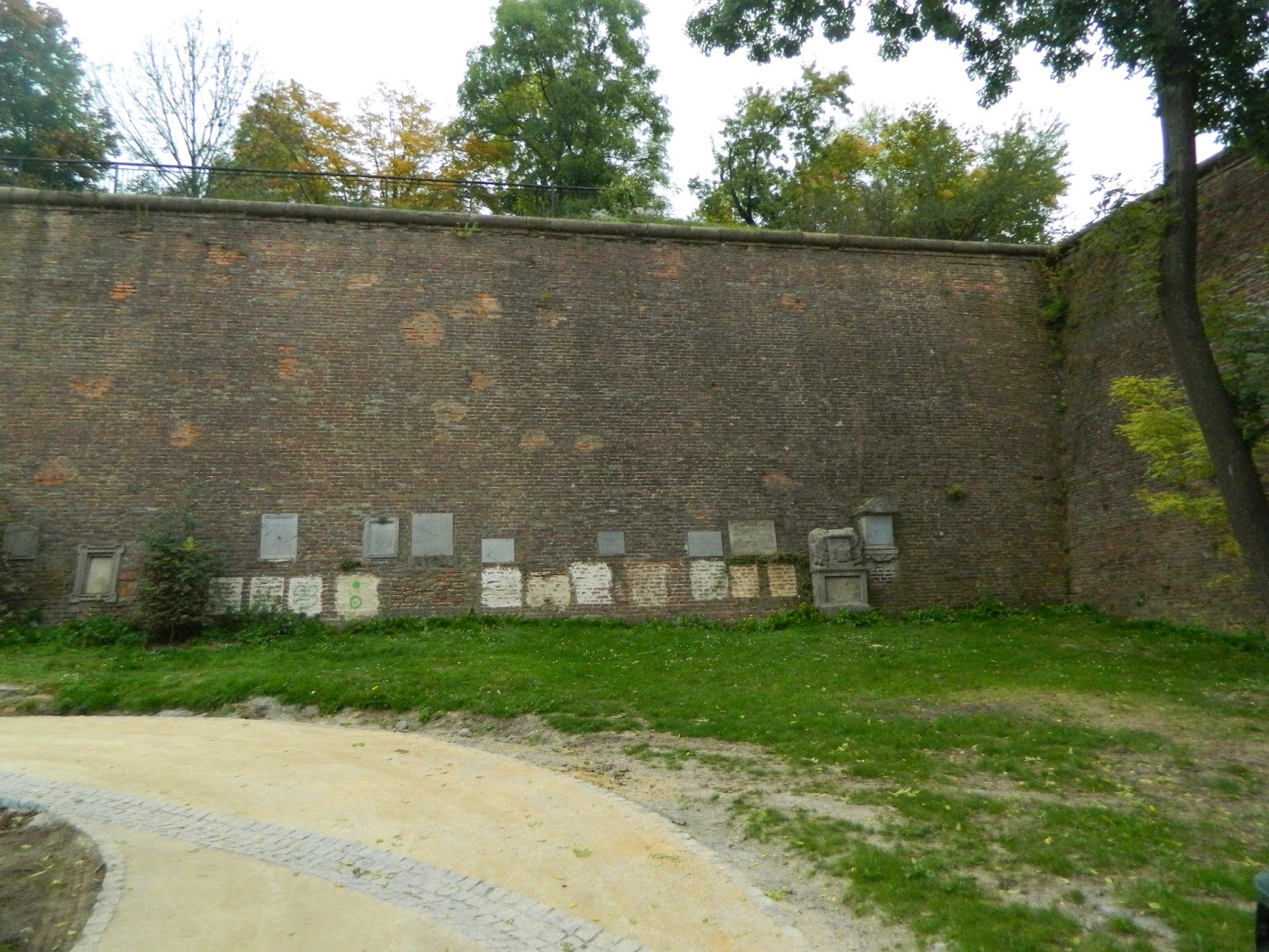
Budete procházet příkopem, který sloužil také jako hřbitov hradčanské dělostřelecké posádky, a zachovaly se zde náhrobní desky umístěné přímo ve zdi. Hřbitov byl založen roku 1786 a kromě důstojníků posádky sloužil také jejich rodinným příslušníkům až do roku 1906.
Skoro na konci vás také čeká pomník připomínající holandského ministra zahraničních věcí, který se v rámci své návštěvy Československa v roce 1977 setkal s tehdejším mluvčím Charty 77 Janem Patočkou; má podobu betonového otisku stromu, který byl dle návrhu sochaře Dominika Langa realizován roce 2017.

Zdroje: Pražská architektura: Významné stavby jedenácti století - Jaroslava Staňková, Jiří Štursa, Svatopluk Voděna; https://forum.valka.cz/topic/view/120329#412904; www.mapy.cz
Bastion
This cache will lead you to the preserved part of the baroque fortification of Prague at Hladkov. This type of fortification was an architectural response to the Thirty Years' War and the development of artillery. It originally originated in France. Its walls were pentagonal bastions whose foreheads were scythe and therefore far more resistant. Unlike the medieval walls, which were only of different thicknesses and high walls, the baroque fortification was made up of the soil from the dirt that had been obtained during the construction of the walls by the excavation of dry ditches; it was covered with opaque and outwardly gray bricks with the reinforcement of the sandstone blocks. These walls were usually not higher than the trench, and their peak formed a ground wave that protruded above the surrounding area.
The construction of the fortifications of Prague began to be planned in 1649 and it started in 1654. For the next 220 years, a massive, 14 kilometers long carapace of 30 bastions closed the medieval city that was accessible from outside by 10 gates (for example, the near Písecká Gate at Belveder Summer Palace).
The individual bastions had their numbers, but also the names. You are standing on the bastion nr. XI, called St. Anne or Star, and the cache will lead you further along the bastion nr. X of St. Francis Borgia. Interesting is this preserved part of the fotification also for it was really fought against. In 1742, it was, quite absurdly, attacked by Austrian cannons from the sites of the nearby Střešovice district that is named On the batteries; those who defended themselves behind the bastions, inside of the city were the French.
The baroque fortifications began to be demolished in 1874 and this allowed the expansion and development of the city.
You will walk through a moat, which also served as a cemetery of the Hradčany artillery crew whose preserved tombstones are placed directly in the wall. The cemetery was founded in 1786 and served to crew officers as well as to their family members until 1906.
Almost at the end of the walk, there is a memorial commemorating the Dutch Minister of Foreign Affairs who, during his visit to Czechoslovakia in 1977, met the then spokesman of Chart 77 Jan Patočka. The memorial takes the form of a concrete print of a tree designed by a Czech sculptor Dominik Lang and was realized in 2017.
Stage 1 (Vyhlídka Maxe van der Stoela)
50° 05’ 523‘‘ N; 14° 23‘ 321‘‘ E
A = počet prken jednoho sedáku jednoho segmentu lavičky okolo stromu
A = the number of planks per seat of one bench segment around the tree
Stage 2 (Hřbitov hradčanské dělostřelecké posádky)
50° 05’ 505 ‘‘ N; 14° 23‘ 324‘‘ E
B = počet písmen křestního jména kaplana Reglchera
B = the number of the letters of Chaplain Regelcher's first name
Stage 3 (Roh bastionu)
50° 05’ 447‘‘ N; 14° 23‘ 277‘‘ E
C = materiál špice bastionu
a) cihly C = 3
b) beton C = 6
c) pískovcové kvádry C = 0
C = bastion's spike material
a) bricks C = 3
b) concrete C = 6
c) sandstone blocks C = 0
Stage 4 (Uliční cedule)
50° 05’ 437 ‘‘ N; 14° 23‘ 237‘‘ E
D = počet písmen názvu místa na uliční ceduli dělený 20 - Ceduli někdo utrhnul, tak název místa najdi na mapě
D = the number of letters of the place name on the street sign divided by 20 Someone tore off the sign, so find the name of the place on the map
Stage 5 (Johannův hrob)
50° 05’ 405 ‘‘ N; 14° 23‘ 210‘‘ E
E= ciferace roku úmrtí Johanna Greifensteina dělená 2
E = a crossfoot (of second order) the year of the death of Johann Greifenstein divided by 2 (even number)
Stage 6 (Bosonohá stezka)
50° 05’ 354‘‘ N; 14° 23‘ 217‘‘ E
F= páté číslo v telefoním čísle 228 2F4 478 dělěné 2
F = the fifth number in the telephone number 228 2F4 478 divided be 2
Final 50° 05.ABC‘ N 14° 23.DEF‘ E