La Earthcache / The Earthcache
L'île de Beauté présente une diversité géologique remarquable, héritée d'une histoire des temps géologiques souvent tumultueuse.
Elle est divisée en deux grandes parties, une corse hercynienne ancienne qui a connu les grandes perturbations de l'orogenèse hercynienne à la fin du Paléozoïque et une corse alpine plus jeune, issue des mouvements à l'origine de la chaîne des Alpes.
Ce nouvel épisode pourrait en fait être un préquel... Qu'y avait-il avant ? Avant la Corse alpine ? Avant la Corse cristalline ?
Partons à la découverte de cette proto-Corse, le Socle panafricain.
► Le Socle panafricain
Les roches du Socle panafricain sont difficiles à observer à la surface, enfouies sous les volumineuses intrusions de granitoïdes du batholite permo-carbonifère de Corse à l'ouest de l'île, et sous les couches sédimentaires du Mésozoïque dans la partie est.
Il est cependant possible d'observer ce socle originel par endroits.
Cet encaissant apparaît, au niveau d'érosion actuel, en panneaux épars dispersés au sein des vastes intrusions de granitoïdes. C'est le cas sur la coupure Galeria—Osani, ou est visible à quelques endroits un socle micaschisteux, de structuration antévarisque (« micaschistes de l'Argentella »).

Partons à la découverte de cette formation originelle.
► Les micaschistes, roches métasédimentaires
La formation panafricaine est composite, elle est formée d'amphibolites et de micaschistes noirâtres. L'ensemble de cette formation est stabilisé dans un métamorphisme de type schistes verts.
Une datation par la méthode Nd/Sm a permis de dater ces formations du socle panafricain comme ayant un âge de 760 ± 160 Ma.
Ces micaschistes de la région cristalline de l'île, aussi bien que ceux des Alpes, des Vosges, du Plateau Central..., peuvent être considérés comme représentant les premières roches de la croûte terrestre.
Les micaschistes visibles le long de la D81 sont des roches métasédimentaires ayant une composition intermédiaire entre celle de métaquartzites et de métagraywackes plus ou moins riches en oxydes ferrotitanés.
La mise à l'air libre provoque une forte oxydation des minéraux contenus dans la roche, donnant une couleur rouille très prononcée à celle-ci.

Ce schiste métamorphique provient de la transformation d'une roche sédimentaire qui, sous l'action de la pression et de la température, présente un feuilletage régulier en plans parallèles : la « schistosité ». Le plan de schistosité est oblique à la direction d'aplatissement (la stratification). La roche horizontale à sa formation a ensuite été soumise à de fortes pressions tectoniques ayant entrainé son basculement.
► Pendage d'une roche litée
Pour qualifier un pendage d'une couche de roche litée, comme c'est le cas d'une roche métasédimentaire de type micaschiste, il faut deux valeurs :
- l'inclinaison des lits par rapport à un plan à l'horizontale, exprimée en degrés.
- la direction du pendage, qui se mesure à 90 degrés de la direction de la couche et définit un angle par rapport au Nord.

L'intensité du pendage peut être graduée de la façon suivante :
- le pendage est nul si le plan (ou la ligne qui lui correspond) mesuré est horizontal. Dans ce cas, il n'y a pas de direction, ou plutôt, le plan est dans toutes les directions.
- le pendage est faible si le plan (ou la ligne) mesuré est presque horizontal (moins de 30 degrés).
- le pendage est fort si le plan (ou la ligne) mesuré est presque vertical (plus de 60 degrés).
- le pendage est dit vertical, si le plan (ou la ligne) mesuré est verticale. Dans ce cas, il n'y a pas de direction pour une ligne, mais il y a une (ou plutôt deux) direction pour un plan.
Corsica has a remarkable geological diversity, inherited from a history of geological times often tumultuous.
It is divided into two large parts, an old Hercynian corsican that experienced the great disturbances of the Hercynian orogeny at the end of the Paleozoic and a younger Alpine Corsican, resulting from the movements at the origin of the chain of the Alps.
This new episode could actually be a prequel ... What was there before? Before alpine Corsica? Before crystalline Corsica?
Let's go to the discovery of this proto-Corsican, the Pan-African Socle.
► The Pan-African Socle
The rocks of the Pan-African Socle are difficult to observe on the surface, buried under the voluminous intrusions of granitoids of the Permo-Carboniferous batholith of Corsica to the west of the island, and under the sedimentary layers of the Mesozoic in the eastern part.
It is however possible to observe this original base in places.
This casing appears, at the level of current erosion, in scattered panels scattered within the vast intrusions of granitoids. This is the case on the Galeria-Osani cut, where is visible in some places a micaschistous base, antévarisque structuring ("micaschists Argentella").
Let's go to the discovery of this original formation.
► Micaschists, metasedimentary rocks
The pan-African formation is composite, consisting of amphibolites and blackish micaschists. The whole of this formation is stabilized in a green schist metamorphism.
Dating by the Nd / Sm method has made it possible to date these formations of the Pan-African basement as having an age of 760 ± 160 Ma.
These micaschists of the crystalline region of the island, as well as those of the Alps, Vosges, Central Plateau ..., can be considered as representing the first rocks of the earth's crust.
The rocks visible along the D81 are micaschists, metasedimentary rocks having an intermediate composition between that of metaquartzites and metagraywackes more or less rich in ferrotitanous oxides.
The venting causes a strong oxidation of minerals contained in the rock, giving a very pronounced rust color to it.
This metamorphic schist comes from the transformation of a sedimentary rock which, under the action of pressure and temperature, presents a regular lamination in parallel planes: the "schistosity". The schistosity plane is oblique to the flattening direction (stratification). The horizontal rock at its formation was then subjected to strong tectonic pressures that caused it to tilt.
► Dip of layered rock
To qualify the dip of a layered rock, like micaschist, it takes two values:
- The inclination of the beds with respect to a plane to the horizontal, in degrees.
- The direction of dip, measured at 90 degrees to the direction of the layer and defines an angle to the North.
The intensity of the dip can be graded as follows:
- Dip is zero if the plan (or the line that corresponds to it) measured is horizontal. In this case, there is no direction, or rather, the plan is in all directions.
- Dip is low if the plan (or line) is measured almost horizontal (under 30 degrees).
- Dip is strong if the plan (or line) is measured almost vertical (over 60 degrees).
- Vertical dip is said, if the plan (or line) is measured vertically. In this case, there is no direction to a line, but there is one (or rather two) direction to a plan.
► Sources bibliographiques / Bibliographical sources
Les Questions / The Questions
La lecture attentive du descriptif de la cache, ainsi qu'une observation des éléments de terrain et un peu de déduction sont normalement suffisants pour répondre aux questions de cette EarthCache.
A careful reading of the description of the cache, as well as observation of terrain features and some deduction is usually sufficient to answer questions of this EarthCache.
Questions pour valider :"Aux origines de la Corse..."
Questions to validate: "At the origins of Corsica ..."
Suivez l'ancienne route jusqu'à l'affleurement sans végétation (zone bleue de la photo WP1) sur votre gauche (attention, la photo est prise à l'envers).
Follow the old road to the outcrop without vegetation (blue area of photo WP1) on your left (be careful, the photo is taken upside down).
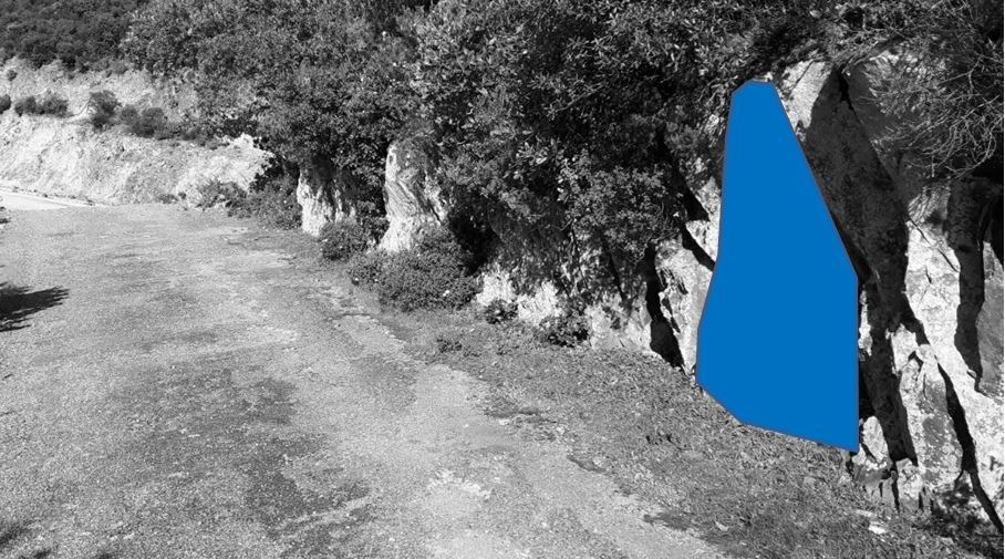
- Question 1 : Décrire la roche devant-vous. Quelle est sa nature ?
- Question 1 : Describe the rock in front of you. What is its nature ?
- Question 2 : Quel mécanisme est à l'origine de sa couleur sur les parties les plus exposées ?
- Question 2 : What mechanism is at the origin of its color?
- Question 3 : Mesurer l'inclinaison des lits par rapport à un plan à l'horizontale. Déduisez-en l'intensité de ce pendage.
- Question 3 : Measure the inclination of the beds with respect to a horizontal plane. Deduce the intensity of this dip.
Vous pouvez vous loguer sans attendre notre confirmation,
mais vous devez nous envoyer les réponses en même temps soit par mail via notre profil (
fafahakkai), soit via la messagerie geocaching.com (Message Center).
S'il y a des problèmes avec vos réponses nous vous en ferons part.
Les logs enregistrés sans réponses seront supprimés.Une photo de vous ou de votre GPS avec la vue vers la mer en arrière plan est la bienvenue, mais n'est pas obligatoire.
You can log this cache without waiting for our confirmation, but you must send us the answers at the same time, by e-mail via our profile (fafahakkai) or by the system of Message Center of geocaching.com.
If there is a problem with your answers we will notify you. The logs recorded without answers will be deleted.
A photo of you or your GPS with the view to the sea in the background is welcome, but not mandatory.
Rappel concernant les « Earthcaches »: Il n'y a pas de conteneur à rechercher ni de logbook à renseigner. Il suffit de se rendre sur les lieux, de répondre aux questions ci-dessus et de nous renvoyer les réponses.
Reminder concerning "Earthcaches": there is neither a container to look for nor a logbook to sign. One need only go to the location, answer to the differents questions and send us the answers.