La Earthcache / The Earthcache
L'île de Beauté présente une diversité géologique remarquable, héritée d'une histoire des temps géologiques souvent tumultueuse.
Elle est divisée en deux grandes parties, une corse hercynienne ancienne qui a connu les grandes perturbations de l'orogenèse hercynienne à la fin du Paléozoïque et une corse alpine plus jeune, issue des mouvements à l'origine de la chaîne des Alpes.
Cet épisode des Géol'Corsica donne un aperçu de la région d'Albertacce, pivot entre Corse cismontica et Corse pumontica, et surtout met en lumière de ce que peux donner le mariage entre une roche plutonique coriace et un fougueux fleuve corse.
► Contexte géologique local
La zone Sud de la commune Albertacce au niveau de Ponte Altu se trouve sur l'épine dorsale géologique de la Corse cristalline, un vaste massif de roches plutoniques datant de l'orogenèse hercynienne.
Nous sommes à la limite entre une unité de Monzogranite à grain moyen et biotite d'une part, et un Granodiorite à amphibole et biotite d'autre part.

Cette roche revêt une couleur blanc laiteux (le feldspath potassique étant blanc comme le plagioclase), son grain est moyen et les macrocristaux rares.
Ce granitoïde présente une faible teneur en biotite (pas de cristaux de couleur sombre) et est caractérisé par l'absence d'amphibole et la rareté des enclaves basiques.
Nous sommes donc en présence d'une roche hololeucocrate (très claire).
A l'air libre, comme c'est souvent le cas pour les roches plutoniques hololeucocrates, la roche prend une coloration rousse correspondant à l'oxydation du fer contenu dans les minéraux.

► Contexte hydrologique locale
Le Golo (en corse Golu) est le plus grand fleuve côtier de Corse. Il se jette dans la mer Tyrrhénienne.
Ce fleuve côtier prend naissance au sud de la Paglia Orba à 1 991 mètres d'altitude, sur la commune d'Albertacce.
Ce cours d'eau est un petit fleuve abondant, bien alimenté par les précipitations elles aussi abondantes, dans les hautes régions centrales de l'île notamment.
Il présente dès sa source des fluctuations saisonnières de débit très marquées, comme bien souvent dans le midi méditerranéen.
Les hautes eaux se déroulent en hiver et au printemps et portent le débit mensuel moyen à un niveau situé entre 19,5 et 25,2 m3/s, de décembre à mai inclus (avec un maximum assez net en avril), alors que son débit à l'étiage ne dépasse pas les 5 m3/s.
► Les Marmites du Golo
Le mariage de ce substrat rocheux plutonique résistant et du débit torrentiel du Golo va mettre en place un lit de rivière aux formes très particulières.
Elles consistent en de très nombreuses cavités se recoupant la plupart du temps en nids de poule, corbeilles, gours, voire en grandes « marmites ».

Quand des cours d'eau avec un courant rapide (au moins en période de crue) comme le Golo coulent sur des roches dures (granitoïdes d'Albertacce), très souvent le lit de ce cours d'eau se creuse de dépressions cylindriques à parois verticales, quelques fois plus larges en bas qu'en haut, parfois totalement fermées mais parfois "éventrées" sur les côtés par l'érosion : les « marmites de géant ».
Ces marmites de géant sont aussi appelées « marmites du diable ».
Ces formes d'altération sont creusées progressivement lors du mouvement de rotation de graviers ou de galets sous l'effet de l'eau.
Le plus souvent, la nature du fond du cours d'eau est plus tendre que les éléments mis en rotation par l'eau, ce qui facilite grandement la formation de ces marmites.

Corsica has a remarkable geological diversity, inherited from a history of geological times often tumultuous.
It is divided into two large parts, an old Hercynian corsican that experienced the great disturbances of the Hercynian orogeny at the end of the Paleozoic and a younger Alpine Corsican, resulting from the movements at the origin of the chain of the Alps.
This episode of Geol'Corsica will give a glimpse of the region of Albertacce, pivot between Corsica cismontica and Corse Pumontica, and especially to highlight what can give the marriage between a tough plutonic rock and a fiery Corsican river.
► Local geological context
The southern area of Albertacce at Ponte Altu is on the geological backbone of crystalline Corsica, a vast mass of plutonic rocks dating from the Hercynian orogeny.
We are on the borderline between a unit of medium grain and biotite Monzogranite on the one hand, and amphibole and biotite Granodiorite on the other hand.
This rock has a milky white color (potassium feldspar is white like plagioclase), its grain is medium and macrocrysts are rare.
This granitoid has a low biotite content (no dark colored crystals) and is characterized by the absence of amphibole and the rarity of basic enclaves.
We are therefore in the presence of a hololeucocratic rock (very clear).
In the open air, as is often the case for hololeucocratic plutonic rocks, the rock takes on a red color corresponding to the oxidation of the iron contained in the minerals.
► Local hydrological context
The Golo (in Corsican Golu) is the largest coastal river of Corsica. He throws himself into the Tyrrhenian Sea.
This coastal river is born in the south of Paglia Orba at 1 991 meters above sea level, in the commune of Albertacce.
This river is a small river abundant, well fed by rainfall also abundant in the central highlands of the island in particular.
It has from its source seasonal fluctuations in flow very marked, as often in the Mediterranean south. High water occurs in winter and spring and has an average monthly discharge of between 19.5 and 25.2 m3 / s, from December to May inclusive (with a fairly high maximum in April), while flow at low water level will not exceed 5 m3 / s.
► The Giant's Kettles of Golo
The marriage of this resistant plutonic bedrock and the torrential flow of the Golo will set up a bed of river with very particular forms.
They consist of very many cavities intersecting most of the time in potholes, baskets, gours, or even in large "Giant's Kettles".
When streams with a fast current (at least in times of flood) like the Golo flow on hard rocks (granitoid Albertacce), very often the bed of this stream is hollow cylindrical depressions with walls vertical, a few times wider at the bottom than at the top, sometimes completely closed but sometimes "disemboweled" on the sides by erosion: the "Giant's Kettles".
These Giant's Kettles are dug progressively during the movement of rotation of gravel or pebbles under the effect of the water of the Golo.
Most often, the nature of the bottom of the stream is softer than the elements rotated by water, which greatly facilitates the formation of these Giant's Kettles.
► Sources bibliographiques / Bibliographical sources
Les Questions / The Questions
La lecture attentive du descriptif de la cache, ainsi qu'une observation des éléments de terrain et un peu de déduction sont normalement suffisants pour répondre aux questions de cette EarthCache.
A careful reading of the description of the cache, as well as observation of terrain features and some deduction is usually sufficient to answer questions of this EarthCache.
!!! CETTE CACHE NE DOIT PAS ËTRE FAITE EN PERIODE DE CRUE DU GOLO !!!
!!! THIS CACHE MUST NOT BE DONE IN GOLO CRUISE PERIOD !!!
Questions pour valider :"Les Marmites du Golo"
Questions to validate: "The Giant's Kettles of Golo"
Point 1 : N 42° 19.184' E 008° 58.581'
Après vous être garé, traversez la route et observez la partie gauche (rive droite) du lit du Golo en contrebas (voir photo WP1) depuis le début de l'escalier ou le belvédère.
After parking, cross the road and observe the left side (right bank) of the Golo bed below (see photo WP1) from the beginning of the staircase or the belvedere.
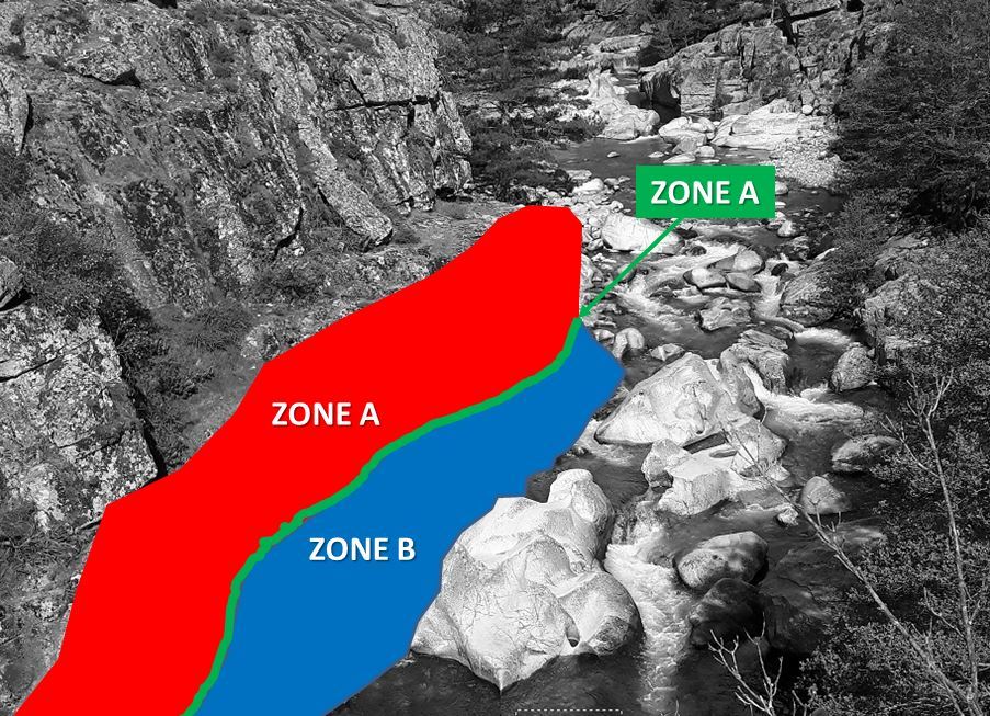
- Question 1 : Décrivez la zone A et la zone B et expliquez leur différence. A quoi correspond la ligne C ?
- Question 1 : Describe area A and area B and explain their difference. What is line C?
Point 2 : N 42° 19.195' E 008° 58.557'
Descendez avec prudence jusqu'au WP2 (uniquement s'il est à pied sec !) et observez le sol au niveau de la zone D bleue.
Go down carefully to WP2 (only if it is dry!) And observe the ground at the blue D zone.

- Question 2 : Donnez les deux couleurs principales que présente la roche de cette zone, et l'origine de ces couleurs.
- Question 2 : Give the two main colors that present the rock of this zone, and the origin of these colors.
Point 3 : N 42° 19.203' E 008° 58.551'
Avancez un peu sur la plate-forme granitique jusqu'au bloc de la photo WP3.
Go a little on the granitic platform to the block of the photo WP3.
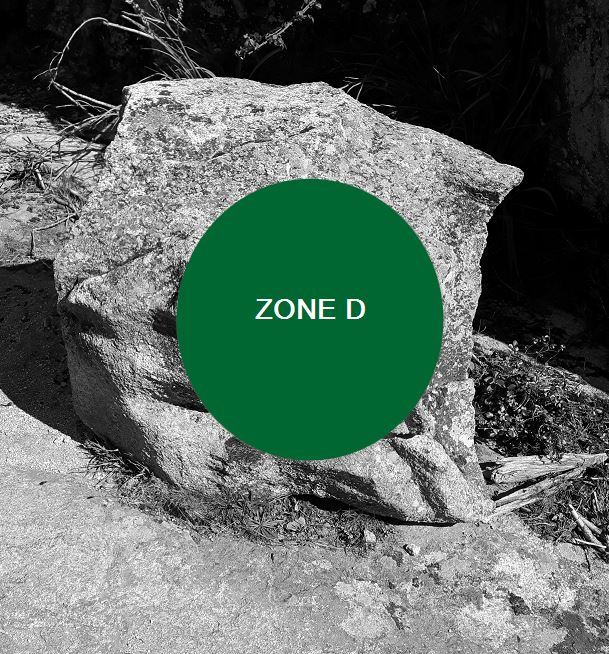
- Question 3 : Qu'y a t-il sous la zone verte D ? Quelle est son diamètre ?
- Question 3 : What is under the green zone D? What is its diameter?
- Question 4 : Frottez la roche au sol devant ce bloc. Décrivez la sensation au toucher, et expliquez la.
- Question 4 : Rub the rock on the ground in front of this block. Describe the feeling to the touch, and explain it.
Vous pouvez vous loguer sans attendre notre confirmation,
mais vous devez nous envoyer les réponses en même temps soit par mail via notre profil (
fafahakkai), soit via la messagerie geocaching.com (Message Center).
S'il y a des problèmes avec vos réponses nous vous en ferons part.
Les logs enregistrés sans réponses seront supprimés.Une photo de vous ou de votre GPS depuis le pont routier avec le pont génois en arrière plan est la bienvenue, mais n'est pas obligatoire.
You can log this cache without waiting for our confirmation, but you must send us the answers at the same time, by e-mail via our profile (fafahakkai) or by the system of Message Center of geocaching.com.
If there is a problem with your answers we will notify you. The logs recorded without answers will be deleted.
A photo of you or your GPS from the road bridge with the Genoese bridge in the background is welcome, but not mandatory.
Rappel concernant les « Earthcaches »: Il n'y a pas de conteneur à rechercher ni de logbook à renseigner. Il suffit de se rendre sur les lieux, de répondre aux questions ci-dessus et de nous renvoyer les réponses.
Reminder concerning "Earthcaches": there is neither a container to look for nor a logbook to sign. One need only go to the location, answer to the differents questions and send us the answers.