
La Earthcache / The Earthcache
L'île de Beauté présente une diversité géologique remarquable, héritée d'une histoire des temps géologiques souvent tumultueuse.
Elle est divisée en deux grandes parties, une corse hercynienne ancienne qui a connu les grandes perturbations de l'orogenèse hercynienne à la fin du Paléozoïque et une corse alpine plus jeune, issue des mouvements à l'origine de la chaîne des Alpes.
La punta d'Umigna est un lieu privilégié pour découvrir les traces laissées par ces perturbations de l'époque varisque.
► Contexte géologique local
La punta d’Umigna s’avance en pleine mer sur 4 km de long. Peu élevé (s’élevant à 64 m d’altitude), le cap est surmonté d’une tour génoise à son extrémité.
La carte géologique de la pointe permet une approche globale :

L’unité composite d'Umigna est formée d'une roche plutonique, de la monzonite quartzique à mégacristaux de feldspaths potassiques blanc (taille de plusieurs centimètres).
Cependant, au milieu de cette première roche magmatique, une seconde roche magmatique complètement différente s'est frayée son chemin pour former des filons caractéristiques.
Il s'agit de filons basiques (basaltes tholéitiques à transitionnels).
En quoi cette roche magmatique diffère-t-elle de son encaissant, magmatique également ?
► Qu'est-ce qu'une roche magmatique ?
Les magmas existent tous dans le manteau, sous l'écorce terrestre. Les roches magmatiques sont issues de la cristallisation de ces magmas.
Il existent deux familles de roches magmatiques, qui vont dépendre de la façon et de l'endroit ou elles se sont cristallisées :

- Les roches volcaniques, ou roches extrusives.
Elles sont issues d'un magma qui s'introduit dans la croûte terrestre puis se fraie un chemin jusqu'à la surface et donner lieu à des coulées de laves qui, en cristallisant, forment des corps extrusifs : volcans sous-marins ou volcans continentaux.
Du fait de cette remontée, la cristallisation est très rapide, ce qui produit de très petits cristaux; la roche résultante sera une roche à fins cristaux qu'on ne distingue généralement pas à l’œil nu, même à l'aide d'une loupe.

- Les roches plutoniques, ou roches intrusives.
Elles sont issues d'un magma qui est resté coincé dans la croûte et y cristalliser pour former des corps intrusifs.
Lorsque le magma cristallise à l'intérieur de la croûte terrestre, l'abaissement de sa température est lent et plus la cristallisation sera lente, plus les cristaux seront gros, généralement bien visibles.

On a donc deux grands groupes de roches ignées: les roches ignées extrusives, à très fins cristaux, et les roches ignées intrusives, à cristaux grossiers.
► Le basalte d'Umigna
Le basalte est une roche volcanique sombre généralement peu évoluée par rapport aux magmas issus directement du manteau terrestre.
C'est la roche la plus abondante en termes de volume à la surface de notre planète. C’est le constituant essentiel de la croûte océanique et on peut le rencontrer dans de nombreux contextes géodynamiques (point chaud, subduction,…).
Elle se caractérise pas des grains invisibles à l’œil nu, signe d'un refroidissement rapide.

Le basalte d'Umigna présente une couleur vert foncé en cassure fraîche, avec des micro-perforations caractérisant la présence de gaz lors de l'extrusion de la roche.
Il présente par ailleurs une patine rousse caractéristique sous sa forme dégradée, lors qu'il est soumis aux éléments extérieurs, caractérisé par une oxydation du fer contenu dans les minéraux de la roche.

Dans le cadre de la pointe d'Umigna, les gisements de basalte sont souvent de type hypovolcanique (sills, filons ou necks) et se sont mis en place entre 305 et 290 Ma à la fin de la mise en place de l’association magmatique U2 (couche plutonique de monzonite quartzique).
Les pressions tectoniques existantes ont alors entrainé une fracturation de la roche encaissante selon un axe général Nord-Est/Sud-Ouest (voir carte géologique du premier point), permettant l'inflitration du basalte.
Corsica has a remarkable geological diversity, inherited from a history of geological times often tumultuous.
It is divided into two large parts, an old Hercynian corsican that experienced the great disturbances of the Hercynian orogeny at the end of the Paleozoic and a younger Alpine Corsican, resulting from the movements at the origin of the chain of the Alps.
The Punta Omigna is a privileged place to discover the traces left by these disturbances of the Variscan era.
► Local geological context
The punta of Umigna moves on the open sea for 4 km long. Low (rising to 64 m altitude), the cape is surmounted by a Genoese tower at its end.
The Umigna composite unit consists of a plutonic rock, quartz monzonite with megacrystals of white feldspars (size of several centimeters).
However, in the middle of this first magmatic rock, a second completely different magmatic rock has pioneered to form characteristic veins. These are basic veins (tholeitic to transitional basalts).
How does this magmatic rock differ from its host, magmatic as well?
► What is a magmatic rock?
Magmas all exist in the mantle, under the earth's crust. The magmatic rocks are the result of the crystallization of these magmas.
There are two families of magmatic rocks, which will depend on the way and the place where they crystallized.
- Volcanic rocks, or extrusive rocks.
They are derived from a magma which penetrates into the earth's crust and then clears its way to the surface and gives rise to lava flows which, by crystallizing, form extrusive bodies: submarine volcanoes or continental volcanoes.
Because of this rise, the crystallization is very rapid, which produces very small crystals; The resulting rock will be a rock with fine crystals that can not be distinguished with the naked eye, even with a magnifying glass.
- Plutonic rocks, or intrusive rocks.
They are derived from a magma that has remained stuck in the crust and crystallized to form intrusive bodies.
When the magma crystallizes inside the earth's crust, the lowering of its temperature is slow and the crystallization will be slow, the crystals will be large, generally well visible.
There are thus two large groups of igneous rocks: extrusive igneous rocks, very fine crystals, and intrusive igneous rocks with coarse crystals.
► The basalt of Umigna
Basalt is a dark volcanic rock generally little evolved compared to magmas directly from the Earth's mantle. It is the most abundant rock in terms of volume on the surface of our planet. It is the essential constituent of the oceanic crust and can be found in many geodynamic contexts (hot spot, subduction, ...).
It is characterized not grains invisible to the naked eye, sign of a rapid cooling.
Umigna basalt has a dark green color in fresh fracture, with micro-perforations characterizing the presence of gas during the extrusion of the rock.
It also has a characteristic red patina in its degraded form, when it is subjected to external elements, characterized by an oxidation of iron contained in the minerals of the rock.
As part of the Umigna Point, the basalt deposits are often of the hypovolcanic type (sills, veins or necks) and were set up between 305 and 290 Ma at the end of the establishment of the magmatic association. U2 (plutonic layer of quartz monzonite).
The existing tectonic pressures then caused fracturing of the host rock along a general north-east / south-west axis allowing the inflection of the basalt.
► Sources bibliographiques / Bibliographical sources
Les Questions / The Questions
La lecture attentive du descriptif de la cache, ainsi qu'une observation des éléments de terrain et un peu de déduction sont normalement suffisants pour répondre aux questions de cette EarthCache.
A careful reading of the description of the cache, as well as observation of terrain features and some deduction is usually sufficient to answer questions of this EarthCache.
Questions pour valider :"Basalte à la Tour d'Umigna"
Questions to validate: "Basalt at the Umigna Tower"
Point 1 : N 42° 08.796 E 008° 33.596
Vous voici devant la tour génoise d'Umigna. Nous allons observer la roche sous la zone rouge de la photo WP1.
Here you are in front of the Genoese tower of Umigna. We will observe the rock under the red zone of photo WP1.
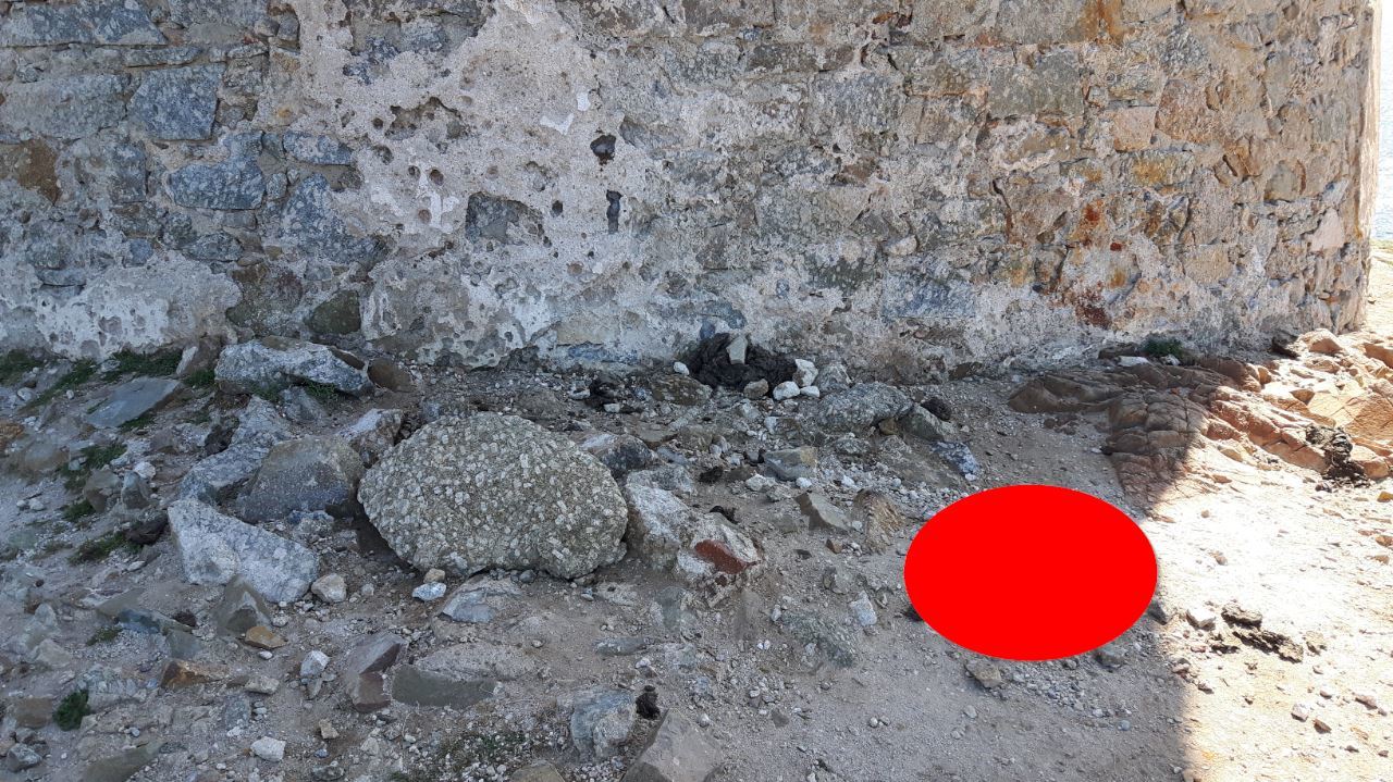
- Question 1 : Décrivez la roche A (granularité, dureté, couleur). De quelle roche s'agit-il ? Cette roche est parcellée de petits trous ; d'après vous quelle en est l'origine ?
- Question 1 : Describe rock A (granularity, hardness, color). What rock is it? This rock is parceled with small holes; according to you, what is its origin?
Point 2 : N 42° 08.789 E 008° 33.597
Contourner maintenant la tour génoise. Une fois derrière, repérer la zone de la photo WP2.
Now go around the Genoese tower. Once behind, locate the area of the photo WP2.

- Question 2 : Evaluer la taille des cristaux de la roche de la zone A. Quelle est la famille de cette roche magmatique ?
- Question 2 : Evaluate the size of the rock crystals in zone A. What is the family of this magmatic rock?
- Question 3 : Evaluer la taille des cristaux de la roche de la zone B. Quelle est la famille de cette roche magmatique ?
- Question 3 : Evaluate the size of the rock crystals in zone A. What is the family of this magmatic rock?
- Question 4 : Quelle est la couleur dominante de la zone partie supérieure de la zone A (zone C entourée en rouge). A quoi est-elle due ?
- Question 4 :What is the dominant color of the upper part of zone A (zone C circled in red). What is it due to?
- Question 5 : Avec votre boussole, évaluer l'axe du filon de basalte passant sous la tour génoise. Est-il cohérent avec la géologie de la pointe d'Umigna ?
- Question 5 : With your compass, evaluate the axis of the basalt vein passing under the Genoese tower. Is it consistent with the geology of Umigna Point?
Vous pouvez vous loguer sans attendre notre confirmation,
mais vous devez nous envoyer les réponses en même temps soit par mail via notre profil (
fafahakkai), soit via la messagerie geocaching.com (Message Center).
S'il y a des problèmes avec vos réponses nous vous en ferons part.
Les logs enregistrés sans réponses seront supprimés.Une photo de vous ou de votre GPS avec la mer ou la pointe d'Umigna en arrière plan est la bienvenue, mais n'est pas obligatoire.
You can log this cache without waiting for our confirmation, but you must send us the answers at the same time, by e-mail via our profile (fafahakkai) or by the system of Message Center of geocaching.com.
If there is a problem with your answers we will notify you. The logs recorded without answers will be deleted.
A photo of you or your GPS with the sea or the tip of Umigna in the background is welcome, but not mandatory.
Rappel concernant les « Earthcaches »: Il n'y a pas de conteneur à rechercher ni de logbook à renseigner. Il suffit de se rendre sur les lieux, de répondre aux questions ci-dessus et de nous renvoyer les réponses.
Reminder concerning "Earthcaches": there is neither a container to look for nor a logbook to sign. One need only go to the location, answer to the differents questions and send us the answers.