Voulez vous " Couchey" avec moi ?
FR :
La Côte entre Beaune et Dijon, se situe à la limite du système d'effondrement-soulèvement allant respectivement de la Bresse, vers l'est, au Morvan, vers l'ouest. Dans ce contexte, la côte viticole laisse place vers l'ouest à des paliers successifs aux altitudes de plus en plus élevées alors que vers l'est s'observe la grande plaine de la Saône, à l'allure monotone et aux altitudes plus basses, qui s'étend jusqu'au Jura.
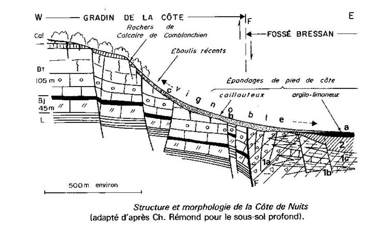
La Côte de Nuits produit principalement des grands vins rouges au bouquet puissant et au corps charpenté. Marquée par la vigueur des pentes dues à la prédominance des calcaires, elle est dominée par le Calcaire de Comblanchien aux abrupts rocheux et dénudés.
Le vignoble est au-dessous, généralement dans le tiers inferieur du talus où la pente plus douce a pu retenir des terres rouges : des limons issus principalement des plateau s suite à la solifluxion datée du périglaciaire, étalés sur la partie basse des versants ( et parfois même sur le piedmont), mêlés à des éboulis et aux débris des formations géologiques sous-jacentes.
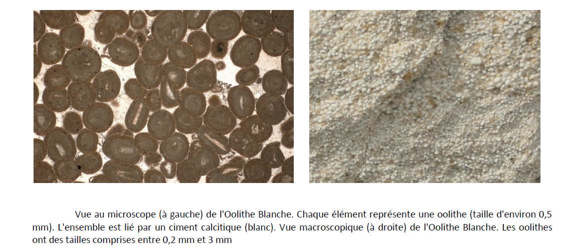
Les bancs supérieurs du calcaire à entroques portent des terres rouges mêlées de plaquettes de pierres. Les marnes adoucissent la pente et donnent une terre grasse, jaune, allégée par les éboulis de l' Oolithe blanche et les plaquettes à entroques remontées par le défoncement naturel ou réalisé par l Homme. Ainsi, la partie supérieure du vignoble déborde largement sur les calcaires bathoniens quand un bon revêtement d’éboulis les tapissent
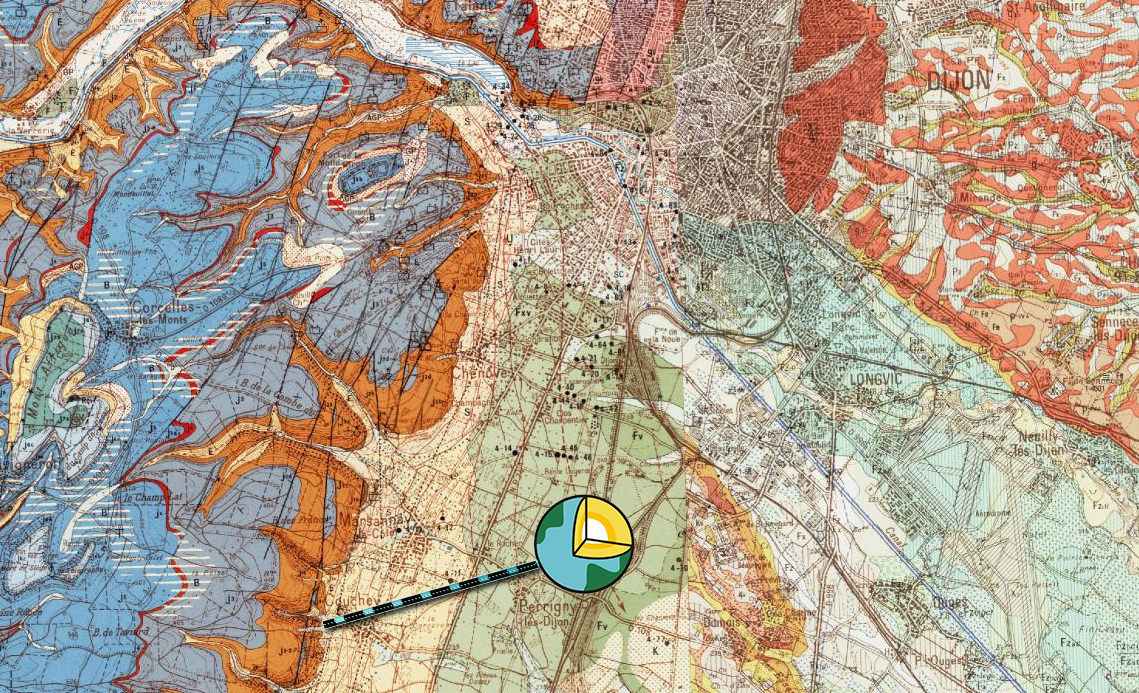
Couchey se situe au Nord de ce système, et permet d’apprecier particulièrement cette disposition du vignoble.
----
EN :
The coast between Beaune and Dijon, lies at the edge of the collapse-rising system going respectively from Bresse, east, Morvan, west. In this context, the winegrowing coast gives way to the west at successive levels at increasingly higher altitudes while towards the east is observed the great plain of the Saone, at monotonous pace and at lower altitudes. , which extends to the Jura.
The Côte de Nuits produces mainly great red wines with a powerful bouquet and a robust body. Marked by the vigor of the slopes due to the predominance of limestones, it is dominated by the Limestone of Comblanchien with bare rocky slopes.
The vineyard is below, usually in the lower third of the slope where the softer slope may have retained red soils: silt mainly from the plateau due to the dated periglacial soliflux spread over the lower slopes (and sometimes even on the piedmont), mixed with scree and debris of the underlying geological formations.
The upper benches of the interlocked limestone bear red soil mixed with platelets of stones. The marls soften the slope and give a fatty, yellow soil, lightened by the scree of the White Oolite and wafers with entroques raised by the natural or man-made abyss. Thus, the upper part of the vineyard overflows largely on the Bathonian limestones when a good coating of scree carpets.
Couchey is located to the north of this system, and allows to appreciate particularly this arrangement of the vineyard.
|
Sources :
https://www.nuiton-beaunoy.com/fr/nous/geologie.html
http://www.vinsvignesvignerons.com/Regions/Bourgogne/COTE-DE-BEAUNE/Le-vignoble
http://www.vinsvignesvignerons.com/Geologie/Geologie-de-la-France/Histoire-geologique-de-la-Bourgogne
https://www.vins-bourgogne.fr/nos-vins-nos-terroirs/nos-atouts-naturels/geologie/de-l-effondrement-de-la-cote-au-bassin-bressan/cote-de-nuits-cote-de-beaune-et-cote-chalonnaise-nees-d-un-bouleversement-geologique,2513,9388.html
infoterre.brgm.fr
|
Rappel concernant les « Earthcaches »: Il n'y a pas de conteneur à rechercher ni de logbook à renseigner. Il suffit de se rendre sur les lieux et d'éxécuter les requêtes du geocacheur.
Loguez cette cache "Found it" et envoyez-moi vos propositions de réponses soit via mon profil, soit via la messagerie geocaching.com (Message Center), EN PRECISANT LE NOM ET CODE GC DE LA CACHE et je vous contacterai en cas de problème.
Il est aussi apprécié d'avoir des photos des géocacheurs sur les lieux de l''EarthCache. Sentez vous inspiré de poster des photos de vous lors de cette visite ( optionnelle mais sympathique)
---
Reminder concerning "Earthcaches": there is neither a container to look for nor a logbook to sign.
Log in this cache " Found it " and send me your answers proposals or via my profile or via geocaching.com messaging (Message Center ) , BY PROVIDING THE NAME AND GC CODE OF THE CACHE and I will contact you in case of problems .
We also enjoy seeing photographs of people visiting this EarthCache. Please feel free to log photos of your visit...(this is entirely optional but funny)
Grace à la lecture du descriptif, votre GPS et votre observation, répondez aux questions suivantes :
Thanks to the reading of the description, your GPS and your observation, answer the following questions:
|
Vers l'Ouest,
Q1 Dans quelle terre s élève la pente ?
Q2 Au fur et à mesure de la montée, cette terre est elle homogène ou bien mélangée avec d autres roches calcaires ?
Q3a Comment la pente se comporte t elle dans les calcaires de front de côte ?
Q3b Comment cela se traduit sur le paysage ?
|
To the West,
Q1 In which land does the slope rise?
Q2 As the climb progresses, is this land homogeneous or mixed with other limestone rocks?
Q3a How does the slope behave in the coastline limestones?
Q3b How does this translate to the landscape?
|
|
Vers l'Est,
Q4 Comment se comporte la pente ?
Q5 Comment est marqué dans le paysage la fin du vignoble ?
Q6 Quelle unité géologique est il possible de voir au-delà ?
|
To the East

Q4 How does the slope behave?

Q5 How is the end of the vineyard marked in the landscape?

Q6 What geological unit is it possible to see beyond?
|
JOYEUX & HAPPY EARTHCACHING