High Elms Walk
This Earthcache was part of a previous High Elms Walk series, but is now just a standalone Earthcache. The current High Elms Walk 2 takes you around the greater High Elms Estate. More details and history of the area can be found on 01 HEW2 - Robin.
Bedrock - Chalk
The High Elms Estate lies on a bedrock of chalk. This Earthcache looks at different classes of rock, and examine chalk, its formation, its properties and uses in more detail.
Classes of Rock
There are three basic types of rock – igneous, sedimentary and metamorphic. These can then be further subdivided, depending on the method of formation.
Igneous rocks form about 65% of the Earth's crust by volume and are formed by the cooling of molten rock, also called magma. The cooling can occur within the Earth’s crust (plutonic or intrusic) which generally slow, producing larger crystals. Granite is an example of a plutonic rock. It can also occur on the surface, such as when lava is ejected from a volcano (volcanic or extrusive), where the cooling is much faster, giving rise to smaller crystals. Basalt is one such rock.
Sedimentary rocks form about 8% of the Earth's crust and are formed by particles of sand, shells and other fragments of materials settling, normally under a lake or sea, and being cemented together. Examples of sedimentary rocks include limestones, which are formed from the remains of organic creatures, and sandstones, which are formed by pieces of rock eroded from other rocks.
Metamorphic rocks form about 27% of the Earth's crust and are formed by subjecting any type of rock to different temperature and pressure conditions than those in which the rock was originally formed. Normally temperatures of greater than 150 to 200°C and pressures of 1500 bar are needed. The original rock transforms and recrystalises. Metamorphic rocks are classified as foliated, if they show banding, eg mica and or non-foliated if they don't have an obvious banding, eg marble.
Limestone
Limestones are a class of sedimentary rocks composed of the mineral calcite or aragonite, which are forms of calcium carbonate, with the chemical formula CaCO3. One of the most common ways in which limestone forms is from the skeletal fragments of marine organisms such as coral that remain after the animal dies. These fall to the bottom of the sea, where they compact and become cemented together. Limestones often contain other materials, such as silica, clay, silt and sand. Because of the method of creation of limestone, and other sedimentary rocks, the material will often exhibit layers, where the composition of each layer may be slightly different from those on either side. This also means that different layers may weather differently, which can make the strata even more obvious.
Chalk
Chalk is a soft, white, porous, sedimentary carbonate rock, a form of limestone. It forms under reasonably deep marine conditions from the gradual accumulation of minute calcite shells (coccoliths) shed from micro-organisms called coccolithophores.
The Cretaceous chalk deposits of Western Europe, are unusual among sedimentary limestones in the thickness of the beds. Most cliffs of chalk have significantly fewer layers unlike most thick sequences of limestone, presumably due to very stable conditions over tens of millions of years.
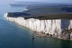
Beachy Head chalk cliffs (by Ian Stannard, Southsea)
The chalk underlying High Elms is part of the Lewes, Seaford and Newhaven Chalk Formations. This chalk was laid down around 72 to 94 million years ago in the Cretaceous Period. The rocks were formed in shallow, warm chalk seas. The map below is taken from the BGS web site. The green areas are chalk, the blue area is part of the Thanet formation of sandstone (56-59m years ago) and the orange area is Lambeth Group of sand, silt and clay (48 to 59m years ago).
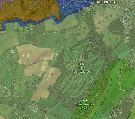
BGS Map of Bedrock Geology
Chalk can be mined in either subsurface or open cast mines. It has a number of uses:
- Blackboard chalk – one of the most obvious uses of chalk, although other minerals such as gypsum, are also used for blackboard chalk.
- Putty for glazing windows contains chalk as a filler in linseed oil.
- Chalk can be used to raise the pH in acidic soils (make it more alkaline)
- Fine chalk particles can also be used for cleaning and polishing.
Flint
Flint is a microcrystalline form of quartz, which occurs in chalk and limestone either as bands parallel to the layers or as embedded nodules. The method of flint formation is not fully understood, but it is probably derived from sponge spicules or other siliceous organisms as water is expelled upwards during compaction. Flint nodules fracture in a conchoidal manner, ie they form a smooth rounded surface resembling the shape of a scallop shell. The interior of the nodule has a glassy lustre and often a dark colour. The exterior of the nodule is normally a lighter, softer material.
Flints have historically been used for sharp tools, due the way in which they fracture. Flint knapping is the process of shaping the flints into the required shape by chipping bits off the main stone. Today most flints are used for decorative purposes, split in half and used on walls.
Dene Hole
In the High Elms Estate grounds are two examples of Dene Holes. A Dene Hole is a small-scale mine for chalk and flint, and comprises a central shaft with foothold to allow the miners to descend, with normally two to four caverns below where the chalk has been mined. Dene Holes have been used since at least Roman times, but the one at the waypoint is thought to be late 18th or early 19th century. The chalk was used to scatter on the fields to improve the clay soil, and the flints were sold to local builders as is evidenced in several local buildings.
The site of one of the Dene Holes can be visited by turning right at the waypoint given below (and in 16 HEW2 - Blackbird) and walking along the footpath (far side of the barrier) or bridleway (nearside of the barrier). The Dene Hole is a roost for bats and is caged off. Both the Dene Hole and the paths to it are located in an area designated as a Site of Special Scientific Interest (SSSI), so please be particularly careful in this area.
You don't have to visit the Dene Hole for the Earthcache.
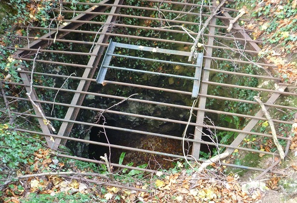
Dene Hole entrance
The Cache
At the coordinates of the Earthcache you will find a number of pieces of rock. One is labelled as Bromley Millennium Rock, which is a piece of Lewisian Gneiss, a metamorphic rock. Unfortunately, the other rocks are not labelled. Please send me the answers to the following questions:
1 Metamorphic - the Millennium stone is Lewisian Gneiss. Please describe the surface of the stone - colours, texture etc and determine whether this metamorphic rock if foliated or non-foliated.
2 Igneous - There is a seat on the grass near the rocks made out of breeze blocks and bricks topped with slate (a metamorphic rock) and ‘book-ended’ by 2 pieces of old kerb stones. Please describe the larger old kerb stone – colour, size, shape, crystal structure. What type of stone do you think this is?
Move to the Flint Pillar waypoint
3 Flint - This pillar used to be at the side of the driveway to the manor. There is a band of knapped flints about 2 ft from the ground. Please tell me how many rows of flints there are in the band
4 Flint - Please describe the flints in the band in terms of their average size, colours, texture etc.
Move to one of the following waypoints
Unfortunately I have been unable to find any exposed local bedrock close to the initial coordinates so the next two waypoints are some distance away - however you only need to visit one of them and you will pass both on your walk round the HEW2 series. There is no obvious large area of exposed bedrock in the area, but when large trees fall over they often bring up some of the rock in their roots. Both of the following waypoints are such fallen trees - I will add the waypoints to the nearest physical caches.
5a Sedimentary Behind 07 HEW2 - Jay there is a large root of a fallen tree covered with a piece of rock. Please describe the rock - colour, surface form, height of the main piece. There are many small pieces of rock around pick one up and describe how it feels. What type of rock do you think this is?
5b Sedimentary Just behind 05 HEW2 - Cuckoo are the roots of a fallen tree and you will see bedrock brought up with the roots. Please measure the width of the rock band and describe it's colour and surface form. There are many small pieces of rock around pick one up and describe how it feels. What type of rock do you think this is?
Photographs taken around the area are welcome, provided they don't give away the answers to the questions. Please log the cache once you have sent me your answers - I'll get back to you if there are any problems.
Some of the caches in the HEW series, and some waypoints of this cache are placed on land designated as a Local Nature Reserve. Where necessary caches have been placed with permission from Donna Cook, Conservation and Community Ranger at High Elms. Please treat the area with care.
Further information
Limestone (Wikipedia)
Chalk (Wikipedia)
Flint (Wikipedia)
Geology of UK (BGS)
Contains British Geological Survey materials ©NERC 2017