The Area around Meldon Quarries is a wealth of both geology and industrial archaeology, both of which are passions of mine. The area boasts three distinct large scale disused quarry zones, with some evidence for other smaller ones, including some of the dump areas that may have been infilled quarries. To highlight this wonderful area I have placed two EarthCaches to highlight this, as well as a Puzzle Cache on a wider geological theme.
This EarthCache focuses on the impressive, and now partially flood, Meldon Limestone quarry. This quarry to the west of the West Okement River was started to be worked during the 19th century for the production of agricultural lime; a product that has long been used to add to the soil to make a number of changes. These include, increasing the pH of acidic soil, providing a source of calcium and magnesium for plants, improvement to water penetration in acidic soils and improving the uptake of major nutrients that plants need [such as nitrogen (N), phosphorous (P) and potassium (K)]. As with Meldon Aplite quarry to the east, there is a wealth of industrial archaeological remains that indicate and give evidence for the activities that were undertaken as part of this exploitation of a geological resource.
The exploitation of limestone in the West Okement valley has a long history and is very extensive. The large partially flooded quarry, which is found at the posted coordinates is the last of 5 quarries at the site for extracting limestone. Many of these other quarries are now either infilled with spoil from later operations or are obscured by the regrowth of nature. However, if you look closely you can start to see unusual areas which could well indicate where these previous quarries were located. As well as the quarries themselves there were a large number of other associated features, many of which survive today. These are two lime kilns (the west one has a provided waypoint and the east one is just the other side of the West Okement River), associated buildings (including way stations), spoil heaps and tramroads for exporting the material. The lime kilns provide a good indicator for the extraction of limestone on the site, with the eastern one being thought to have been constructed early in the 18th century, and the western one being constructed between 1875 and 1885.
As mentioned there were as many as 5 discrete quarries that were part of the extraction of limestone in the Meldon area. It is thought that the earliest phase of this was on the eastern bank of the West Okement River, comprising of three quarries. The earliest of these is the most northerly where the eastern lime kiln is located and once this one had stopped being used the two more southerly quarries were opened and the lime kiln constructed. All of these quarries are now difficult to see as they have been obscured by waste material from later workings. Based on map evidence the workings on the eastern side of the river appear to have stopped, and working transfered to the western side, sometime around `1839. The waste material was transported across the river, to infill the old workings, and are result in both linear and finger heaps. Linear heaps as the name suggests are linear, extending as far as they can being created by the dumping of material. Finger heaps are very similar, however they tend to fan off from a more central point, resulting in what looks like a hand from above.
The formation of limestone, and its resulting chemical composition, is what has made limestone an important resource in agriculture, particularly in Devon. Limestone is a sedimentary rock formed by the deposition of shells, corals, algal, and fecal debris on the sea floor. This material builds up over time and eventually the lower deposits are subjected to intense pressure from the weight of material above. Over time this pressure results in the lower parts of the deposited material being compressed into rock, forming limestone. As a result of the material forming the deposits the rock is largely comprised of calcium carbonate [CaCO3] in the form of the mineral calcite. This is an alkaline composition and therefore is highly useful in neutralising acidic soils, which are commonly found in Devon.
The process for producing agricultural lime, which is called quick lime, follows a couple of steps. The first step after extracting the limestone is to crush it into appropriately sides pieces. After this it was taken via carts to the 'charging platform' where it was poured into the top of the kiln and tipped into the circular shaft. The limestone was layered and sandwiched between layers of charcoal. Once the kiln was fully stacked a fire was lit in the firegate chamber and the fire was controlled to slowly burn at a high temperature. When the kiln had cooled the resulting quick lime was shovelled out through the fire grate straight into carts. Evidence can often be found where limestone has either been stored, or burnt, as it often leaves behind calcium oxide (which is also known as quick lime). One of these common features is stalactites, which form when water washes through limestone rocks, or in this case material that is coated in calcium oxide from quick lime production. The second evidence is the calcium oxide itself, which appears like a white crystalline deposit, often on the brickwork around kilns, especially where airflow would have been present.
As well as a lovely example of industrial archaeology and the history of industry of north Dartmoor during the last few centuries, the surviving rock face of this particular quarry provide an ideal example for folding and manipulation of geologic units. At the location the overhanging rock face indicates the very impressive example of the angle of dip, which is the angle from horizontal of a geologic unit. There is also a dip running along to the rock face, indicating that the apparent angle of dip is somewhere to the north or north-west.
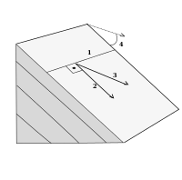
Description of the image above.
1) The strike line is the representation of the line representing the intersection of the feature, be it a geologic unit or a fault line, with a horizontal plane.
2) The direction of dip is the direction based on the strike line, and is always perpendicular (90 degrees) to this line.
3) Apparent dip is an alternative to the angle of dip because it isn't calculated from the strike line. This means that because the strike line is not always visible in the field this technique is easier to use. It is measured in any vertical plane that is not perpendicular to the strike. The rock face at this EarthCache is a good example of where the apparent dip is employed instead of 'dip'. It is possible to convert this apparent dip to the angle of dip using trigonometry in cases where you know the strike.
4) The true angle of dip is the angle from horizontal perpendicular to the strike line.
To log this EarthCache go to the posted coordinates and the two other waypoints and send me a message or email answering these following questions
Go to the posted coordinates
1) Look across the water to the rock face. Estimate the approximate angle of dip of the rock face into the rockface (approximately north-west) (where 90 degrees is vertical 0 degrees is horizontal).
2) Look at the rockface. Are the layers of rock horizontal or still dipped running across the rockface?
3) What is the length of the quarry? (use the reference point provided)
Go to the lime kiln waypoint
4) On the masonry of the firegate chamber (arch and the roof) there are two indicators that lime was processed in this kiln, what are they?
Go to the mining activity waypoint
5) What type of evidence for mining activity can you see at this location?
As a bonus it would be much appreciated (although not required) if you take any photographs of any pieces of industrial archaeology (that isn't a spoiler) to add them to your log.