|
 |
|
 |
|
 |
|
|
sebastien13960 |
|
theyoungstone |
|
sebetauré |
|
 FRANÇAIS
Résumé géologique de la Provence :
L’histoire de la Provence commence au primaire avec la surrection de la partie sud de la chaîne hercynienne, l’activité volcanique dans l’Estérel et l’érosion qui se manifeste durant cette période.
Au secondaire, les transgressions marines déposent d’importantes couches de sédiments marins calcaires. Ces terrains vont se soulever, glisser, se plisser lors de la formation des Pyrénées et des Alpes et former les chaînons alpins de Provence (Lubéron, Alpilles, Arc de Castellane, reliefs de la Sainte Baume, Sainte Victoire, Étoile, Nerthe…).
Parallèlement, suite au mouvement de remontée de l’Afrique vers l’Europe, on assistera à l’effondrement du bassin rhodanien et méditerranéen, à la formation du Golfe du Lion, à la séparation de la Corse et de la Sardaigne, au positionnement de la Péninsule Ibérique et à la mise en place de la mer Méditerranée.
Particularité du lieu :
Dans cette région limite du delta du Rhône et de la Provence calcaire, deux mers se sont succédées :
- La mer Alpine, il y a environ 200 Millions d’années (fin du Trias, début du Jurassique).
- La mer Méditerranée apparaît il y a environ 20 Millions d’années (au Miocène Burdigalien).
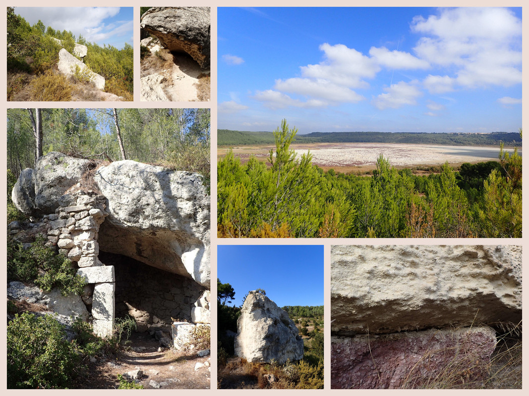
Les différentes roches visibles datent du Paléocène et de l’Éocène, donc relativement ‘’jeunes’’.
Sur place vous pouvez observer les différents ‘’temps’’ géologiques qui ont marqué ce lieu :
En bas l’étang est au niveau de la mer Méditerranéenne actuelle, la couche blanche que l‘on aperçoit est le dépôt de sel marin actuel.
- Un premier niveau laisse apparaître des calcaires coquilliers (huîtres et St Jacques principalement).
- Un deuxième niveau est composé d’argilite* et de conglomérats.
- Un troisième niveau est formé d’argilite* et de grès.
- Un quatrième niveau (faible ici) contient la calcarénite** blanche.
- Un cinquième niveau est formé de grès compact.
- Puis au-dessus, correspondant à la forêt domaniale de Castillon, est lui composé de calcarénite** rousse.
* L'argilite est une forme de roche sédimentaire argileuse indurée à grain fin et très peu perméable. Elles résultent de la consolidation de couches parallèles de micro-feuillets d'argile ou de boue argileuse fine.
** La calcarénite est un grès formé par la consolidation de sables calcaires. Ce type de roches se forme notamment dans les zones littorales des régions tropicales ou dans les massifs dunaires constitués par les sables d’érosion des récifs coralliens.
ICI plus particulièrement on va reconnaître des conglomérats.
Un conglomérat est une roche détritique (issue de la dégradation mécanique d'autres roches) composée de morceaux discernables liés entre eux par un ciment naturel. Pour être considérés comme discernables, les morceaux doivent mesurer plus de 2 mm (en dessous de cette taille, on aurait affaire à un grès et non plus à un conglomérat). Les conglomérats sont le plus souvent de nature sédimentaire, mais ils peuvent également être volcaniques.
Parmi les conglomérats, on trouve:
- Les brèches, composées de blocs anguleux.
- Les poudingues composés de galets aux formes arrondies.
- Les tillites qui contiennent à la fois des cailloux anguleux et des galets arrondis.
Beaucoup de conglomérats ont été formés au moment où la mer envahissait une surface primitivement continentale (transgression), et plus particulièrement dans une zone basse.
Remerciements : Wikipédia. BRGM.
Au vu de ce que vous voyez sur place puis en marchant le long de ce sentier sur à peine 30 mètres depuis le PZ et à la lecture de l'énoncé de cette Earthcache, 4 questions pour sa validation :
- N°1 : Que voyez-vous en haut du coteau, ce qui correspond au cinquième niveau, ?
- N°2 : De quel type de conglomérats sont composés les blocs, face à vous?
- N°3 : Regardez bien, une forme géométrique a été découpée sur le haut de l’un des blocs face à vous...quelle forme géométrique?
- N°4 : L’un des blocs apparaît sous une forme de tête de requin, entrez dans sa gueule (un abri naturel) levez la tête et vous apercevez de multiples trous bien ovalisés...Mais pourquoi?
Optionnel : Prendre une photo de votre GPS (avec ou sans vous) au P.Z. de la Earthcache, côté étang!
"Loguez cette cache "Found it" et envoyez-moi vos propositions de réponses soit via mon profil, soit via la messagerie geocaching.com (Message Center), et je vous contacterai en cas de problème."
Bonne découverte.

 ENGLISH
Geological summary of Provence:
The history of Provence begins at the primary level with the uplift of the southern part of the Hercynian range, the volcanic activity in the Esterel and the erosion that manifests itself during this period. At the secondary level, marine transgressions deposit important layers of calcareous marine sediments. These lands will rise, slip, crease during the formation of the Pyrenees and the Alps and form the Alpine chain of Provence (Lubéron, Alpilles, Arc de Castellane, reliefs of Sainte Baume, Sainte Victoire, Étoile, Nerthe ...).
At the same time, following the upward movement from Africa to Europe, the Rhone-Mediterranean and Mediterranean basin will collapse, the Gulf of Lion will form, the Corsica and Sardinia will be separated, the Iberian Peninsula and the setting up of the Mediterranean sea.
Particularity of this place:
In this region bordering the delta of the Rhone and the limestone Provence, two seas are succeeded each other :
- The Alpine Sea, about 200 million years ago (end of the Triassic, early Jurassic).
- The Mediterranean Sea appears about 20 million years ago (in the Burdigalian Miocene).
The different visible rocks date from the Paleocene and the Eocene, so relatively ‘’young".
On site you can observe the different geological 'times' that marked this place:
Down the pond is at the level of the current Mediterranean sea, the white layer that one sees is the deposit of current sea salt.
- A first level reveals shellfish limestones (mainly oysters and St Jacques shell).
- A second level is composed of argillite * and conglomerates.
- A third level is formed of argillite * and sandstone.
- A fourth level (low here) contains white calcarenite.
- A fifth level consists of compact sandstone.
- Then above, corresponding to the forest of Castillon, it is composed of calcarenite ** redhead.
* The argillite is a form of fine grained indurated clayey sedimentary rock with very low permeability. They result from the consolidation of parallel layers of clay micro-layers or fine clay mud.
** The calcarenite is a sandstone formed by the consolidation of calcareous sands. This type of rocks is formed especially in the coastal zones of tropical regions or in the dune massifs constituted by the sands of erosion of the coral reefs.
Here more particularly we will recognize conglomerates.
A conglomerate is a detrital rock (derived from the mechanical degradation of other rocks) composed of discernible pieces linked together by a natural cement. To be considered discernible, the pieces must measure more than 2 mm (below this size, it would be a sandstone and not a conglomerate). Conglomerates are mostly sedimentary in nature, but they can also be volcanic.
Among the conglomerates are:
- The breaches, composed of angular blocks.
- Puddings composed of rounded-shaped pebbles.
- Tillites that contain both angular pebbles and rounded pebbles.
Many conglomerates were formed when the sea invaded a primitively continental surface (transgression), and more particularly in a low zone.
Thanks: Wikipedia. BRGM.
In view of what you see on the spot and walking along this path on just 30 meters from the PZ and on reading the statement of this Earthcache, 4 questions for its validation:
- N°1: What do you see at the top of the hill, which corresponds to the fifth level?
- N°2: What kind of conglomerates are the blocks facing you?
- N°3: Look carefully, a geometric shape has been cut out on top of one of the blocks facing you ...what geometric shape?
- N°4: One of the blocks appears in the form of a shark's head, enter under his face (a natural shelter) raise your head and you see multiple holes ovalized ... But why?
Optional: Take a picture of your GPS (with or without you) to the Earthcache PZ, pond side please !
Log in this cache "Found it" and send me your answers proposals either via my profile or via geocaching.com messaging (Message Center), and I will contact you in case of problems."
Have a good discovery.
"En tant que propriétaire de la géocache, j'assure que le lien Facebook mène vers un groupe Facebook local actif et utile à la communauté et qu'il contribue au géocaching de manière positive. Ce lien n'a pas été vérifié par le Geocaching HQ ou les reviewers."