La tourbière du Venec est située sur le territoire de la commune de Brennilis. La réserve naturelle est gérée depuis le 29 juin 1994 par l'association Bretagne Vivante - SEPNB. C'est un élément important du réseau Natura 2000 et de la trame verte et bleue de Bretagne. Le premier plan de gestion de la Réserve Naturelle a été validé par le Ministère de l'Aménagement du Territoire et de l'environnement le 21 janvier 1999. La commune a en 2009 donné son accord pour qu'une partie de son territoire (zones protégées de l’arrière de la commune et de la vallée de l’Ellez) puisse devenir ENS.
C'est un élément important du réseau Natura 2000 et de la trame verte et bleue de Bretagne. Le premier plan de gestion de la Réserve Naturelle a été validé par le Ministère de l'Aménagement du Territoire et de l'environnement le 21 janvier 1999. La commune a en 2009 donné son accord pour qu'une partie de son territoire (zones protégées de l’arrière de la commune et de la vallée de l’Ellez) puisse devenir ENS.
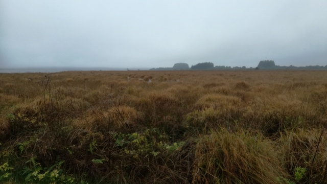
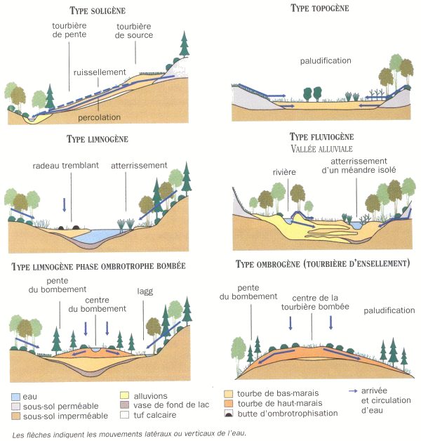
Elle fait partie du Yeun-Elez, vaste ensemble de tourbières et de marais situé en plein cœur des monts d’Arrée. La réserve naturelle est constituée d’une tourbière bombée (dite ombrogène), d’une zone de bas-marais acides (dit lagg), de landes et de prairies humides.
La tourbière constitue une avancée dans le réservoir Saint-Michel qui recouvre depuis 1938 près de 500 hectares, soit le tiers de la cuvette du Yeun-Elez. La création de ce réservoir isole la tourbière du Venec des autres tourbières du Yeun-Elez. La zone périphérique est caractérisée d’une part par des landes ouvertes en contact direct avec la tourbière et d’autre part par un paysage de bocage avec des champs clos.
POURQUOI CE NOM ?
Selon la légende, le " Yeun Elez " est une vaste tourbière, occupant une gigantesque cuvette au cœur des Monts d'Arrée. Le centre de cette cuvette était naguère rempli par une bourbe mouvante appelée le " Youdic " (Petite Bouillie). C'est là que la tradition bretonne situait la porte de l'enfer. On disait que, pour se débarrasser d'un revenant, il fallait avoir recours à un exorciste qui le transformait en chien noir et le faisait conduire de presbytère en presbytère, jusqu'à un prêtre d'une paroisse de l'Arrée. Le saint homme emmenait l'animal au bord du Youdic, lui passait prestement son étole autour du cou et le précipitait dans le marais.
Les villages verdoyants du Yeun Elez se trouvent situés à environ 30mn de Brest, Quimper et Morlaix, endroits idéaux pour rayonner de la côte Nord à la côte Sud.
Les tourbières font partie des puits de carbone naturels. Au sens large du terme, un puits de carbone ou puits CO2 est un réservoir, naturel ou artificiel, de carbone qui absorbe le carbone de l'atmosphère et donc contribue à diminuer la quantité de CO2 atmosphérique, et en conséquence, le réchauffement de la planète (toutefois cette « conséquence » est une hypothèse non démontrée à ce jour, les puits de carbone étant gros émetteurs de vapeur d'eau : voir gaz à effet de serre). La taille de ces réservoirs augmente constamment, à l'inverse d'une source de carbone. Les principaux puits étaient les processus biologiques de production de charbon, pétrole, gaz naturels, hydrates de méthane et roches calcaires. Ce sont aujourd'hui les océans, les sols (humus, tourbière) et certains milieux végétalistes (forêt en formation).
Les nombreux stades dynamiques de tourbière et le fort contingent d’espèces atlantiques et boréales lui confèrent un intérêt patrimonial et pédagogique certain. Il s’agit de la dernière zone ombrogène encore "en état" sur les trois existants en Bretagne. L’épaisseur de la tourbe atteint 4,5 à 5 m au niveau du bombement. Cette matière est très acide, sans oxygène et au frais, elle se conserve aussi bien qu’un bocal de cornichon dans un frigo. On retrouve ainsi des graines, des grains de pollen ou du charbon de bois en parfait état sous quelques mètres de tourbe. Comme la tourbe s’accumule en s’entassant d’1 mm par an, le pollen récupéré à cinq mètres de profondeur s’est donc déposé il y a 5000 ans. On peut ainsi savoir quelles plantes poussaient à cette époque et reconstituer un paysage pour chaque période de notre histoire.
On trouve sur la réserve naturelle des communautés à linaigrette ainsi qu’un ensemble remarquable de sphaignes.
Parmi les mammifères, on compte la loutre d’Europe (de passage) et le castor d’Europe à l’ouest du site. Pour les oiseaux, citons le busard des marais, le faucon hobereau, le hibou des marais et les oiseaux d’eau en stationnement sur l’anse en eau libre.
Pour les insectes, on trouve le sympetrum noir, le damier de la succise, l’argyronète, et la dolomède.
Dans les amphibiens, l’alyte et le triton palmé.
POURQUOI FAUT IL PROTEGER LES TOURBIERES ?
Les tourbières, comme la plupart des zones humides, n’étaient autrefois considérées que comme des marais putrides, insalubres, inquiétants et dangereux, aux eaux croupissantes porteuses de miasmes et peuplées de créatures glauques et malfaisantes... Il fallait à tout prix les assécher, les assainir, au nom de la salubrité publique.
Ce n’est que très récemment, depuis une trentaine d’années seulement, que l’on a pu mieux cerner et comprendre le rôle majeur qu’assurent ces milieux et admettre l’intérêt, voire la nécessité, de leur conservation. Situées à l’interface entre les milieux terrestres et aquatiques, les tourbières sont de formidables réservoirs de vie mais également de véritables infrastructures naturelles qui jouent un rôle essentiel dans le cycle de l’eau.
On sait, aujourd’hui, qu’elles assurent une multitude de fonctions, communes aux zones humides en général, mais aussi avec de nombreuses spécificités. Ainsi, on reconnaît aux tourbières, entre autres : une valeur biologique et écologique ; une valeur scientifique, archéologique et ethnologique ; une valeur fonctionnelle ; une valeur économique et une valeur paysagère, récréative et éducative.
PRINCIPALES MENACES :
- Destructions physiques
On entend par destruction physique, toute modification de la nature du sol, qui peut être plus ou moins irrémédiable pour la conservation des biotopes. (Plantations forestières, exploitation de la tourbe, comblement pour la construction de routes ou d'autoroute , les terrassements pour les aménagements touristiques ou de zones artisanales ou industrielles)
- Perturbation des conditions d'alimentation en eau (Drainage, assainissement, modification du bassin versant...)
- Atteintes à la qualité des eaux (Pollutions...)
- Arrêt des pratiques d'entretien
- Autres menaces...
Parmi les autres menaces, on peut citer les pollutions biologiques (introduction d'espèces non-autochtones), les risques de sur piétinement (bovins, sentiers), ainsi que la cueillette de certaines espèces (droséras).
Questions
1) Rendez vous au point de référence pour déterminer la forme et donc le type de cette tourbière. Aidez vous d'un objet plan.
2) Toujours au point de référence vous devez constater la spécificité de la parcelle. Indiquer si c'est un avantage ou un inconvénient pour que la tourbière perdure ?
3) Quelle était (approximativement) la hauteur de la tourbière à la mort de Alain Ier de Bretagne dit le Grand (Alan Iañ en breton) en 907 ?
"Loguez cette cache "Found it" et envoyez-moi vos propositions de réponses soit via mon profil, soit via la messagerie geocaching.com (Message Center), et je vous contacterai en cas de problème."
Les photos sur site de votre GPS sont les bienvenues mais facultatives.
En complément et pour aller plus loin avec mes remerciements :
https://sd-g1.archive-host.com/membres/up/adf960c77ed80883b4772d8987b42cfe5315f9d2/livret_venec.pdf
http://www.bretagne-vivante.org/Agir-ensemble/Nos-reserves-naturelles/Reserve-Naturelle-Nationale-du-Venec
http://www.yeun-elez.com/
Wikipédia.org
Sartor35
The Venec peat bog is located on the territory of the municipality of Brennilis.
The Nature Reserve has been managed since 29 June 1994 by the association Bretagne Vivante - SEPNB.
It is an important element of the Natura 2000 network and the green and blue network of Brittany. The first management plan for the Nature Reserve was validated by the Ministry of Territorial Development and the Environment on 21 January 1999. The municipality approved in 2009 that part of its territory (protected areas from the back of the commune and the valley of the Ellez) could become ENS.
It is part of the Yeun-Elez, a vast group of peat bogs and marshes located in the heart of the Arrée mountains. The nature reserve consists of a bulbous bog (called ombrogène), an area of low-marshes acid (lagg), moors and wet meadows.
The peat bog is an advance in the Saint-Michel reservoir, which since 1938 has covered nearly 500 hectares, or one-third of the Yeun-Elez basin. The creation of this reservoir isolates the peat bog of the Venec from the other peat bogs of the Yeun-Elez. The peripheral zone is characterized on the one hand by open heaths in direct contact with the peat bog and on the other hand by a landscape of bocage with closed fields.
WHY THIS NAME?
According to legend, the "Yeun Elez" is a vast bog, occupying a gigantic basin in the heart of the Monts d'Arrée. The center of this basin was once filled with a moving mire called the "Youdic" (Petite Bouillie). This is where the Breton tradition placed the door of hell.
It was said that in order to get rid of a ghost, it was necessary to have recourse to an exorcist who transformed him into a black dog and led him from presbytery to presbytery, to a priest in a parish of the Arree. The holy man took the animal to the edge of the Yodic, swiftly passed his stole round his neck and threw it into the swamp.
The green villages of Yeun Elez are located about 30mn from Brest, Quimper and Morlaix, ideal places to radiate from the North coast to the South coast.
Peatlands are part of natural carbon sinks. In the broad sense of the term, a carbon sink or CO2 sink is a natural or artificial reservoir of carbon that absorbs carbon from the atmosphere and thus helps to reduce the amount of atmospheric CO2 and consequently the warming of the atmosphere. (this "consequence" is an unproven hypothesis to date, as carbon sinks are large emitters of water vapor: see greenhouse gases). The size of these reservoirs is constantly increasing, unlike a carbon source. The main wells were biological processes for the production of coal, oil, natural gas, methane hydrates and calcareous rocks. Today, it is the oceans, the soils (humus, peat bog) and certain vegetalist environments (forest in formation).
The numerous dynamic stages of peatland and the strong contingent of Atlantic and boreal species give it a certain patrimonial and pedagogical interest. This is the last ombrogene zone still "in state" on the three existing in Brittany. The thickness of the peat reaches 4.5 to 5 m at the level of the bulge. This material is very acid, without oxygen and in the cool, it keeps as well as a jar of pickle in a fridge. Seeds, grains of pollen or charcoal in perfect condition are found in a few meters of peat. As peat accumulates by accumulating 1 mm per year, pollen recovered five meters deep deposited 5000 years ago. We can thus know what plants were growing at that time and reconstruct a landscape for each period of our history.
On the nature reserve there are communities with cotton plants and a remarkable group of sphagnum mosses.
Among the mammals are the European otter (passing) and the European beaver west of the site. For birds, the harrier of the marshes, the hawk-hawk, the owl of the marshes and the water birds parked on the cove in open water.
For insects, we find the black sympetrum, the checkerboard of the succise, the argyronetes, and the dolomède.
In amphibians, alyte and palmated newt.
WHY SHOULD THE TURBINES BE PROTECTED?
Peat bogs, like most wetlands, were once considered only putrid, unhealthy, disturbing and dangerous marshes, with stagnant waters carrying miasma and populated by creepy and evil creatures ... They had to be dried up at all costs , sanitize them, in the name of public health.
It is only very recently, in the last thirty years, that we have been able to better understand and understand the major role played by these environments and to recognize the interest, and even the necessity, of their conservation. Located at the interface between terrestrial and aquatic environments, peatlands are formidable reservoirs of life but also natural infrastructures that play an essential role in the water cycle.
Today, it is known that they perform a multitude of functions, common to wetlands in general, but also with many specificities. Thus, peat bogs are recognized, among others: biological and ecological value; scientific, archaeological and ethnological value; a functional value; an economic value and a landscape, recreational and educational value.
PRINCIPAL THREATS:
- Physical Destruction
Physical destruction is understood to mean any change in the nature of the soil, which may be more or less irremediable for the conservation of biotopes. (Forest plantations, exploitation of peat, filling for road or motorway construction, earthworks for tourist installations or artisanal or industrial zones)
- Disturbance of water supply conditions (drainage, sanitation, modification of the watershed ...)
- Influences on water quality (Pollution ...)
- Stop maintenance practices
- Other Threats ...
Other threats include biological pollution (introduction of non-indigenous species), risks of trampling (cattle, trails), and the gathering of certain species (droseras).
Questions
1) Go to the reference point to determine the shape and thus the type of this peat bog. Help yourself with a plan object. 2) Always at the point of reference you must note the specificity of the parcel. Indicate if it is an advantage or a disadvantage for the peat bog? 3) What was (approximately) the height of the peat bog at the death of Alain Ier de Bretagne said the Great (Alan Iañ in Breton) in 907??
"Log in this" Found it "cache and send me your responses either via my profile or via the geocaching.com messaging service, and I'll contact you if there's a problem."
On-site photos of your GPS are welcome but optional.
In addition and to go further with my thanks:
https://sd-g1.archive-host.com/membres/up/adf960c77ed80883b4772d8987b42cfe5315f9d2/livret_venec.pdf
http://www.bretagne-vivante.org/Agir-ensemble/Nos-reserves-naturelles/Reserve-Naturelle-Nationale-du-Venec
http://www.yeun-elez.com/
at Wikipedia.org
Sartor35