Getting to GZ and to the river channels involves clambering over potentially wet and slippery rocks. Please take care and neither myself or Groundspeak accept any responsibility for any injuries.
The River Taw, which is one of many rivers which rises on Dartmoor National Park. The river runs a 45 mile course from near Hangingstone Hill on Dartmoor to its mouth at Barnstaple in north Devon. The River Taw is on of Devon's longest rivers and provides a range of important habitats along its course. This includes the most important nature reserves in England, Braunton Burrows, which is a Unesco Biosphere Reserve and a Special Area of Conservation.
The posted coordinates for this cache will take you to a part of the River Taw, in the wooded area of Belstone Cleave. When you arrive at them you will find that the River Taw splits into two channels here, forming an island. One of these channels is the main course of the River Taw and the other one is a secondary channel.
The secondary channel is impressively cut through the bedrock. It is currently either blocked off from the main channel or the river is not high enough to enter the channel. During times of high water it is likely that the channel fills with water and becomes part of the River Taw.
Glossary of terms
Discharge - The volume of water passing through the river channel.
Particle Fraction - A subgroup based on certain parameters, such as size. In this case an example of a fraction would be pebbles or sand.
Linear Rate - A constant rate, E.G. slowing of velocity by 5 cm/s per minute.
River in Spate - Term used to describe a river swollen due to extremely high levels of rainfall.
Velocity - The speed of the river travelling downstream.
Carrying Capacity
The carrying capacity of a river is its ability to carry particles and transport them further downstream. The carrying capacity of a river is based on two main factors, these are the velocity of the flow and the discharge. The faster the water is flowing the water can carry heavier items, which normally means larger particles. Slow moving streams are usually characterised by smaller particles found on the river bed because a faster moving river would be able to keep them moving. This is also true of rivers that have a high discharge level.
In a river that has uniform flow from source to mouth (which of course will never exist) the particles found will be uniform across the entire length. This is because the carrying capacity of the river would not change. In practise the composition of a river will change based on a number of factors. These include channel shape, rivers joining, obstacles and rainfall.
Channel shape can effect the carrying capacity in a number of ways. The steeper the gradient the higher the effect of gravity on the water flowing and therefore the faster the water is flowing. The shape of the channel also effects the flow velocity. When the channel narrows the water has to flow faster to channel the same amount of water and when the channel widens the velocity slows.
Rivers joining add extra water to the channel. This will increase the carrying capacity of the river over what it would have been without the river joining.
Obstacles within the channel will have an effect on the flow of the river. Items such as rocks may cause areas of slower flow, and therefore more deposition, than the rest of the channel. Obstacles such as fallen trees, large boulders or man made features such as weirs can have very different effects. If they are blocking part of the channel then the water velocity on this free section will have to be higher to continue the same discharge levels. However, they may also have the effect of slowing water in other areas of the channel creating uneven deposition.
Rainfall levels has the obvious impact of increasing the amount of water entering the river, increasing the discharge. If the river stays within the same channel then to compensate for this increased discharge the velocity of the river will have to increase. This increase in both velocity and discharge will lead to a river that is in 'spate.
Particle Deposition
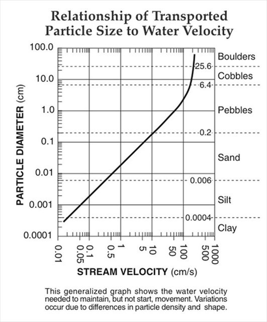
The deposition and pickup in river channels without any additional factors is very regular and therefore is extremely helpful in estimating the velocity of the water traveling in the channel. If a rivers velocity slows, such as happens after extremely heavy rainfall, then as the water slows the hardest to carry (i.e. the heaviest) particles will always be deposited first. In a river without additional factors this would lead to particles sorting, the heaviest would be on the bottom and the progressively lighter fractions would be sorted around them. E.G. If a river is flowing at 1000 cm/s then all particle sizes within the flow graph will be moved. However, if the river slows at a linear rate to 10 cm/s then the boulders will be the first particle size deposited followed by cobbles and then pebbles. The sand will still be kept in suspension as the river still has enough velocity to keep them moving. This means that when trying to ascertain a rivers carrying capacity the lightest fraction deposited, used for the velocity calculation, is normally found handily on the top of heavier sediments.
NB (1)
For the calculation of river speed the smallest well represented fraction should be chosen. So if a river has a few boulders but mostly made of sand, the sand size should be used for the best results. This is because the smallest particles will be dropped last as a river speed falls.
NB (2)
In the case of dry channels it is often the case that even if boulders were the smallest fraction dropped by the water before drying up that over time some of the smaller fractions will fall in over time, largely through surface run off. An easy way to spot the smallest fraction deposited by the running water is to follow the particle size down. If you find boulders, cobbles and silt, then because the river did not deposit the fractions in between it is likely that the silt was not deposited by the river.
To log this EarthCache go to the posted coordinates and send me a message or email answering these following questions (don't worry about being too precise with the number for the velocity as obviously using a ruler and the graph provided is not as accurate as it could be)
1) Estimate how wide and deep the dry channel is?
2) Look at the particles in the dry channel and measure the average size of the smallest fraction deposited by the river.
3) Look at the particles dropped by the river in the main channel and measure the average size of the smallest fraction.
4) Based on the two different measurements, use the graph provided to estimate the current velocity of the River Taw and the velocity of the River Taw when the dry channel was formed.
5) Based on your observations and calculations what can you deduce about the water carrying capacity when it is high enough to enter the secondary channel, compared to normal flow in the main channel?
6) What indications within the secondary channel suggests that it isn't filled very often?