This EarthCache is located at the first Bullseye Stone along the Grimstone and Sortridge Leat. From the recommended parking it is about a 2 km round trip so make sure that you respect Dartmoor and take all the usual precautions (map, compass, waterproofs, water etc). From the parking there are some stunning views off to the east of the moors and the reference point here is for a board showing you what you can see. This is entirely optional and you do not have to go to this to complete the EarthCache.
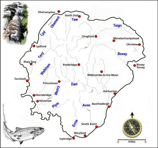
If you have spent any time walking on Dartmoor, or looking at the OS maps of the area, it soon becomes clear that Dartmoor is criss crossed by waterways called leats. Leats are manmade waterways that have been used for centuries for controlling and utilising the water runoff from Dartmoor. Dartmoor is well known for being a wild, windy and, most of all, a wet place, and is known as the last great wilderness in southwest England. The average annual rainfall of Dartmoor and lowland Devon have been recorded from Princetown, 510 metres, and Teignmouth, 68 metres. That the average annual rainfall between 1971 and 2000 at Princetown was 1974.2 mm compared to Teignmouth at 850 mm, highlights the difference of precipitation on Dartmoor compared to the surrounding lowland areas of Devon. Dartmoor, due to its height and the levels of rainfall, is the source of many of Devon’s major rivers. These includes the Teign, Dart, Avon, Erme, Yealm, Plym, Tavy, Okement and Taw. These all start out in the many bogs and mire, before draining down into a clear channel that form the beginnings of these streams and rivers. The construction of leats were the ideal way to exploit water as an important resource.
Throughout the history of building leats there have been a number of reasons for their construction. The most important two are for drinking water and for industrial activities. In 1591 one of the most well known leats on Dartmoor, the ‘Drakes Leat’, was constructed to channel drinking water directly to the growing population of Plymouth. Many of the Medieval leats were set up to provide water for the tin industry. This is true of Wheal Jewell, which had a long system of leats to transport water for a considerable distance. Finches Foundry in Sticklepath, which is still operational thanks to the National Trust, takes water from the River Taw near Belstone Cleve.
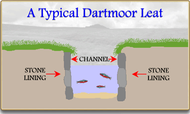
At the posted coordinates you will find a Bullseye stone, which simply put, is a slab of granite with a hole drilled into. They are a cheap, simple and low maintenance method of regulating water flows from leats and are extensively used in the leats of Dartmoor. They are commonly used to regulate water flow off the main leat to farms of houses. Probably the best location on the moor to see a Bullseye Stone is on the Grimstone and Sortridge Leat, which is the location of the posted coordinates. This leat has been the main supply of water to 35 houses and farms for the last c. 700 years. To supply the 35 houses and farms a number of branch leats are taken off the main leat, each by the use of a Bullseye Stone to regulate the water flow. The first of these is located at the posted coordinates, nearby the stone cross Windy Post, and it leads down to Pew Tor Cottage.
At the posted coordinates you can see the effects of both man and geology on the water courses of Dartmoor. Mans impact is pretty obvious, with a clearly man made leat and the Bullseye Stone. The colour, taste and chemical composition of the water running through the leat have been affected by Dartmoor's geology.
The composition of the water running through this leat, and the Bullseye Stone, is dependent on several natural factors, (geological, topographical, meteorological, hydrological, and biological) in the drainage basin and varies with seasonal differences in runoff volumes, weather conditions, and water levels. The most important of these influences are geological, hydrological and climatic, since this affects both quality and quantity of the water available.
This mean that the water will differ significantly in taste and colour depending on the geologies that it has passed through. This is mainly caused by mineral from the bedrock, such as calcium carbonates from chalk, dissolving into the groundwater. The amount and type of minerals that are dissolved in the water is what gives waters their initial taste. There are different factors that control the dissolved minerals in the ground water. (I) The type of minerals in the surrounding geology, (II) the chemical state of the ground water, (III), the duration or length of time which water makes contact with the minerals and the rocks. .
As the water passes through the geology of the area, both bedrock and superficial, minerals and chemicals are dissolved into the water. This process is known as leaching. Leaching can occur in both the surrounding soils, and causes a problem in agriculture, as well as in the geology of an area. Leaching occurs when water comes into contact with both the bedrock and the superficial geology. On Dartmoor it is the superficial geology (the geology that is above the bedrock) which has the most effect on the water. The superficial geology across much of Dartmoor is peat, which is present in many of the mire and bogs that many of the waterways start out from. They are highly acidic and have little lag time between rainfall and increased flows. The colour of the water in the waterways of Dartmoor is very distinctive and can often be seen where the water is of sufficient depth. There are two main reasons for this one Dartmoor. The first is from the humic acid, which is formed when organic matter decays to form peat, which covers large areas of Dartmoor. The other, which you will determine as part of this EarthCache, is one of those listed in the table below. Together these two give the water its distinctive colour that can be seen over much of the moor, as well as further down the rivers that start on Dartmoor.

To log this EarthCache go to the posted coordinates and send me a message or email answering these following questions
1) What is the approximate diameter of the hole in the Bullseye Stone?
2) Describe the colour of the water, in the main leat rather than the stream through the Bullseye Stone?
3) Based on your observation to question 2 other than the humic acid, what do you think has caused the colouration of the water?
4) What process has caused these two elements to occur in the water?
5) Nearby the Bullseye Stone there is a wooden sign, what does it say?