|
![]()
Virtual Reward @ Pico Ruivo


Comecemos por falar do Pico Ruivo a partir da Achada do Teixeira, percurso de curta distância, 2.8 km ida mais 2.8 km de regresso com uma duração aproximada de 1:30h a 2:00h, que leva os caminhantes até aos 1861 metros de altitude, a terceira montanha mais alta de Portugal e a mais alta da Madeira.
Ao longo do percurso encontramos vários abrigos onde pode-se parar para descansar um pouco ou fazer um lanche ou abrigar-se pois a variação climática é brusca.
Falemos também da vasta vegetação abundante nesta área como as urzes e os musgos não esquecendo os vários habitantes que aqui vivem como o melro preto, o tentilhão-da-madeira, o bisbis e a endémica freira da madeira.
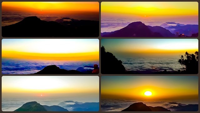
À medida que vamos avançando vão surgindo paisagens maravilhosas compostas pelas imponentes montanhas e picos da ilha como o Pico das Torres e o Pico do Arieiro.
Além disso, nesta paisagem repleta de serras, mar e população, ainda é possível distinguir a rocha da Penha d'Águia, a Ponta de São Lourenço e em dias de boa visibilidade pode-se avistar o Porto Santo.
Próximo da casa de abrigo do Pico Ruivo encontram-se os acessos de três percursos que levam a distintos pontos da ilha, PR 1 Vereda do Pico do Arieiro, PR 1.3 Vereda da Encumeada e PR 1.1 Vereda da Ilha.
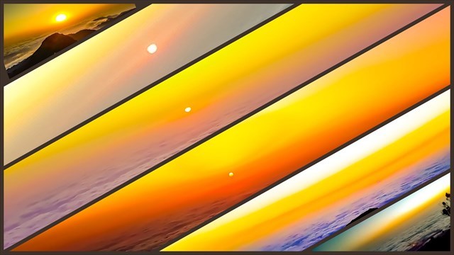
Ao chegar ao Pico Ruivo, o caminhante poderá maravilhar-se com a magnífica paisagem de 360 graus.
Observe a grandeza dos picos, as povoações e os terrenos agrícolas, o mar e as nuvens.
Desfrute da sensação de gradeza que este lugar proporciona.

Let's begin by talking about the Pico Ruivo from Achada do Teixeira, short distance, 2.8 km one way plus 2.8 km return with an approximate duration of 1: 30h to 2: 00h, which takes hikers up to 1861 meters, the third highest mountain in Portugal and the highest in Madeira.
Along the way we find several shelters where you can stop for a little rest or a snack or shelter because the climatic variation is abrupt.
Let us also speak of the vast abundant vegetation in this area as heathers and mosses, not forgetting the various inhabitants who live here, such as blackbird, wood finch, bisbis and the endemic nun of wood.
As we go along, wonderful landscapes are created, composed by the imposing mountains and peaks of the island, such as Pico das Torres and Pico do Arieiro.
In addition, in this landscape full of mountains, sea and population, it is still possible to distinguish the rock from the Penha d'Águia, the Ponta de São Lourenço and on days of good visibility you can see Porto Santo.
Near the shelter of Pico Ruivo are the accesses of three routes that lead to different points of the island, PR 1 Vereda do Pico do Arieiro, PR 1.3 Vereda da Encumeada and PR 1.1 Vereda da Ilha.
Upon reaching Pico Ruivo, the hiker can marvel at the magnificent 360-degree landscape.
Note the greatness of the peaks, the settlements and the agricultural lands, the sea and the clouds.
Enjoy the gritty feeling that this place provides.
Para sua segurança:
Antes de iniciar o percurso verifique se é adequado à sua condição física;
Preste atenção às marcas e quaisquer outros pontos de referência ao longo do trilho;
Mantenha-se no percurso marcado;
Verifique a previsão meteorológicas para melhor avaliar as condicões do trilho;
Transporte alguma comida e água de reserva;
Utilize roupa e calçado apropriados (botas, casaco e impermeável);
Vestir várias camadas de roupa confortáveis é uma boa maneira de se adaptar à intensidade da actividade e às mundancas climáticas;
Bons sapatos ou botas de caminhadas tornam o passeio mais fácil e seguro;
Use protetor solar mesmo em dias nublados;
Um chapéu protege o rosto e a cabeça do sol e ajuda a ficar quente quando está frio;
Em algumas zonas a rede móvel pode ser inconstante ou até inexistente;
Leve um powerbank;
Leve uma lanterna;
Leve um estojo de primeiros socorros;
Informe alguém do local para onde se dirige e a que horas pensa regressar;
Em caso de emergência ligue o 112;
Proteção Civil: +351 291 700 112
GNR: +351 291 214 460
O portão está aberto diariamente das 7h às 21h no horário de inverno e no horário de verão está sempre aberto quando as condições climáticas o permitem.
For your safety:
Before starting the course, check if it is appropriate to your physical condition;
Pay attention to the marks and any other reference points along the track;
Stay on track marked;
Check the weather forecast to better assess the condition of the track;
Transport some food and reserve water;
Wear appropriate clothing and footwear (boots, coat and raincoat);
Wearing comfortable layers of clothing is a good way of adapting to the intensity of activity and weather conditions;
Good hiking shoes or boots make the ride easier and safer;
Wear sunscreen even on cloudy days;
A hat protects the face and head from the sun and helps to get warm when it is cold;
In some areas the mobile network may be inconsistent or even non-existent;
Take a powerbank;
Carry a flashlight;
Take a first-aid kit;
Inform someone of where you are going and when you are planning to return;
In case of emergency call 112;
Civil Protection: +351 291 700 112
GNR: +351 291 214 460
The gate is open daily from 7 a.m. to 9 p.m. in winter time and in summer time is always open when weather conditions allow.

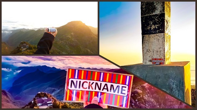
Como logar esta cache:
Deves dirigir-te às coordenadas e tirar duas fotos onde apareça o teu nickname de geocaching escrito, em dois locais, um no geodésico e outro à paisagem envolvente. Podes utilizar uma folha de papel, carimbo, telemóvel, T-shirt, entre outros, o importante é que apareça o teu nickname. Podes aparecer na fotografia ou não, a escolha é tua.
How to log this cache:
You should go to the coordinates and take two photos where your geocaching nickname appears, in two places, one in the geodesic and the other in the surrounding landscape. You can use a sheet of paper, stamp, mobile phone, T-shirt, among others, the important thing is that your nickname appears. You can appear in the photograph or not, the choice is yours.
Exemplos de onde e como deves tirar as fotos:
Examples of where and how you should take the photos:
Virtual Reward - 2017/2018
Esta Cache Virtual faz parte de uma versão limitada de Caches Virtuais criada entre 24 de agosto de 2017 e 24 de agosto de 2018. Apenas 4,000 proprietários de cache tiveram a oportunidade de "esconder" uma Cache Virtual. Saiba mais sobre Virtual Rewards no Blog de Geocaching.
Virtual Reward - 2017/2018
This Virtual Cache is part of a limited release of Virtuals created between August 24, 2017 and August 24, 2018. Only 4,000 cache owners were given the opportunity to hide a Virtual Cache. Learn more about Virtual Rewards on the Geocaching Blog.
|