Please Note: This is a Military Training Area on which live firing and other pyrotechnics may be used. The area is generally open public access. One of the safety rules for public access is:- Do not, (and ensure that children do not) approach, touch or pick up any metal objects lying on the ground. Please obey all bylaws and locally posted information concerning times when the area may be closed. These may be physical barriers, marker posts, flags, lights or manned control posts.
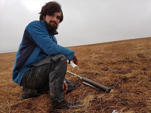
Above is a photograph of me taking a core sample of well humified peat as part of my masters degree. As you can tell peat, and its potential uses, is something that I am very interested in and I am glad to finally be able to dedicate an EarthCache to the wonderful, if slightly smelly, substance!
The geology of Dartmoor is well documented and already has a number of EarthCaches dedicated to it, with most focus on the granite bedrock. The geology of an area can largely be divided into to main parts, these are the bedrock and the superficial deposits. The bedrock is defined as a term used for the main mass of rocks whether exposed at the surface in outcrops, or concealed beneath superficial deposits/water. In the case of Dartmoor this bedrock varies, but the main upper outcrop of the Moor, including the location of this EarthCache, is granite. Superficial geology is the youngest deposits in an area and overly the bedrock in areas where the bedrock is not exposed. Superficial deposits can vary from deposits from rivers, such as gravels, sands and silts, to organic accumulation from the local flora (plant species).
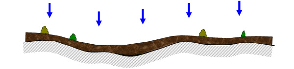
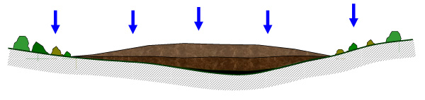
Dartmoor has several superficial geologies that lie over the granite bedrock, in all locations other than where it is exposed, such as the tors. The largest of these superficial geologies is peat, and it covers most of the upland area of Dartmoor. The depth of this superficial peat ranges from mere centimetres to in excess of 6 metres, such as Winney's Down. Dartmoor has two types of bogs, in which peat is formed. The first, and by far the largest by area, is the Blanket Bog, and the second is Raised Bog.
Blanket Bog is the general term given the the mantle of peat, at least 50 cm thick, that overlies the geological unit underneath, on areas of the Moor that is over 400m. The two main areas of Blanket Bogs are surrounding Cranmere Pool in the north and Naker's Hill in the south. In total Dartmoor has c.8500 ha of Blanket Bog.
Raised Bogs are much less common, certainly in the south west, than Blanket Bogs. They are bogs where the peat material forms a dome rising above the surrounding land. The only example of a Raised Bog, not only on Dartmoor but in the whole of Devon and Cornwall, is found at Tor Royal Bog, just outside of Princetown.
Peat is formed from decomposing flora material, most commonly from sphagnum moss, as well as grass. In very fresh peat the plant material is very clear and here is very little fully decomposed material. Normally this plant material would rot down to form the organic component of the soil. However, when this decay of the plant matter is inhibited by water logging, the process of peat formation is started. The decomposing plant matter forms what is known as a 'blanket bog', which is given to an area of waterlogged ground that has this layer of partially decayed and alive plant material on its surface. This upper layer of material is known as the 'Acrotelm' and normally occurs from the surface to a depth of no more than 30 cm. This soil layer can be described as the 'living' layer and as the name suggests contains living plant material. The Acrotelm keeps building over time and as more accumulates on the surface the older deposits below begin to get compressed by the combined weight of the material above them. This layer below the Acrotelm is known as the 'Catotelm'.
The Catotelm is the soil layer below the Acrotelm, and is an anaerobic layer with only dead material. As such this layer does not contain any of the aerobic microorganisms that form the peat in the Acrotelm. As a result of this the Catotelm does not undergo any further decomposition or peat formation, which means that it is this layer which is extremely valuable to the investigation of the palaeoclimate and palaeoevironment of peatland areas. Unlike the Acrotelm layer above this lower layer tends to have much less recognisable plant material within it, and some, or all, of it will have already decomposed. The only change this layer undergoes is the compaction, due to the weight of peat above, into progressively more dense peat.
The study of peat, which is not limited to the two fields mentioned above, has resulted in a number of conventions used to easily define and categorise peat. This EarthCache will focus on the convention of humification, which amongst other uses, is a well established and commonly used technique for palaeoclimatic reconstruction.
The science behind the humification of peat, and any other highly organic matter, is the changing of a number of groups of substances. Organic material is made up of many components such as proteins, carbohydrates, lipids, etc. During the humification process these substances are converted into humic substances. After that the humic substances slowly change into carbon deposits, which is the reason why peat has been an important fuel source throughout history. This process would not normally happen in locations where the ground isn't water logged. This conversion process is highly dependent of the level of the water table, because the material below the water table is effectively preserved and the humification processes is halted. This means that the higher the water table, the less time that the organic material has to break down. Conversely the lower the water table the longer the break down of the humification process can occur, and a higher humification value is achieved.
As well as the level of visible organic material another good indication of the level of humification is the colour of the peat. With the breakdown of organic material into humic substances this generally leads to the peat having a darker colour. A good example of this, which can be seen at the posted coordinates, is the colour of the water draining off the blanket bog above the peat bank to the Fur Tor Brook below. The humic acid, amongst other things, is leached out of the peat and give the water of Dartmoor its characteristic reddish brown colour.
As mentioned above a common method of identifying the humification value of peat is to look at the remaining plant material still visible within the peat. Because the levels of humification changes based on the water table, and water logging of the peat, variations frequently occur, leading to what can be termed as 'zones'. These zones are a nice simple way of grouping together peat deposits that share the same level of humification based on descriptions in the table below.

The location of this EarthCache is an ideal spot to view a cross section through the full, or almost full, sequence of peat found on the lower slopes of Fur Tor above the Fur Tor Brook. I assume that this face was naturally formed, possibly through a combination of erosion by sheep and water. This location is also good because it shows the geological unit underneath the peat, which in this location appears to be granite gravels, pebbles and cobbles.
NB you will require a tape measure to properly answer the questions below
To log this EarthCache, please visit the posted coordinates and send me the answers, via the messenger service or email, to the following questions. I suggest that you use the bank on the right hand side as it is vertical, cleaner and the peat zones are better defined.
1) Measure the total height of the peat banks.
2) Look at the back of the exposure of peat where you should see the geological unit underlying the peat. Describe its appearance. i.e. is it bedrock, soil, sand or gravel.
Look at the plant remains within the peat and use this to answer the following questions. (Hint: I could see 3 clearly distinct zones of humifiction, although it could be subdivided further. For the purposes of this EarthCache assume there are at least 3 zones, which should be obvious to see, but if you feel adventurous feel free to further subdivide the zone providing you qualify your reasoning)
3) Look at the peat. How many zones, based on the included plant remains, can you identify?
4) Measure the height of each of your zones.
5) Describe the levels and appearance of the plant material within your zones and the changes between the zones.
6) Based on your previous answers and the table provided assign each one a humification value (H1-H10)
This EarthCache is situated within the North Dartmoor SSSI. This SSSI was partly established because of Dartmoor's Blanket Bogs importance as a rare habitat and environment. As such it is a criminal offence to wilfully damage existing peat deposits or the process in which peat is formed. So when visiting this site, and any others with peat exposed, it is important not to damage the peat exposure in any way, including taking 'samples' or 'feeling' the peat.