Le lac des Plagnes
Le lac des Plages et la tourbière de Cubourré ont une origine glaciaire. Les glaciers sculptent les paysages mettant en évidence des ombilics et des verrous. Les ombilics deviennent des lacs qui se sont comblés avec le temps. Le lac de Cubourré laisse place à une tourbière. Aujourd’hui, l’eau poursuit le travail d’érosion et façonne les reliefs.

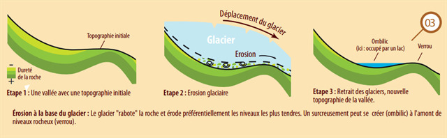
Ombilic (glaciaire) : Zone déprimée, de surcreusement glaciaire, située à l’amont d’un verrou. Si le verrou n’est pas complètement entaillé par une gorge fluviatile, l’ombilic est occupé par un lac, qui se transforme alors par comblement alluvionnaire, en une zone plate où divague la rivière.
Verrou : Un verrou est un ressaut qui barre le profil longitudinal de la vallée et qu’une rivière entaille plus ou moins profondément. C’est un endroit où l’érosion glaciaire a moins affouillé qu’à l’aval et à l’amont. Il est le plus souvent dû à une barrière de roches plus dures.
Le lac des Plagnes s’est donc naturellement comblé au fil du temps et a évolué en marais. Aujourd’hui, le lac que vous voyez est un plan d’eau d’agrément, aménagé en 1978 sur cet ancien lac glaciaire. Les hommes ont construit une digue, l’ont approfondi et agrandi. Profond de 4 mètres environ et couvrant 4 hectares, il est destiné à la pêche et au tourisme d’été. Un sentier balisé permet d’en faire le tour.

L’hiver, le lac est complètement gelé et fait office de patinoire.
Pour valider cette earthcache,
Pour valider cette earthcache, envoyez-moi, en précisant le nom de l’earthcache, vos réponses par mail ou messagerie geocaching aux questions suivantes.Vous pouvez loguer "Found it", et je vous contacterai en cas de nécessité.
Allez aux coordonnées indiquées au début de ce descriptif. Vous trouverez un panneau d'information. Afin de valider votre visite, vous devez répondre aux questions suivantes :
- Il y a 2.5 millions d’années, quels sommets émergent au dessus des glaciers ?
- A quelles dates les glaciers se retirent du Chablais ?
- Entre - 15 000 et – 12 000 ans, que se passe-t-il ?
- Que déversent les cours d’eau qui alimentent les 2 lacs ?
Suivez maintenant le sentier qui borde le lac jusqu'au waypoint 2. Vous êtes au pied du verrou. Vous devez répondre aux questions suivantes :
- Qu'est-ce qui descend de ce verrou ?.
- D'où est-ce que cela provient ?.
- Prendre OBLIGATOIREMENT une photo de vous, de votre GPS ou d’un objet personnel, à joindre à votre log, au bord du lac. (Guidelines des earthcaches du 10 juin 2019).
Rappel : pour les earthcaches, il n’y a pas de boites à trouver mais des réponses à chercher.
The Plagnes Lake
The Plagnes Lake and the bog of Cubourré have a glacial origin. Glaciers sculpted the landscape to reveal glacial hollows and rock bars. The hollows become lakes which have been infilled with time. The Cubourré Lake has changed into a peat bog. Today, it is water continues to work to erode and shape the relief.
Glacial hollow : A depressed area of glacial overcrowding, located upstream of a bog. If the bog is not completely cut by a fluvial throat, the hollow is occupied by a lake, which is then transformed by alluvial filling into a flat zone where the river wanders.
Rock bar : A rock bar is a jump that straddles the longitudinal profile of the valley and a river gaps more or less deeply. It is a place where glacial erosion has less eroded than downstream and upstream. It is most often due to a barrier of harder rocks.
Plagnes Lake naturally filled up over time and evolved in marshes. Today, the lake you see is a pleasure lake, built in 1978 on this former glacial lake. The men built a dike, deepened and enlarged it. Deep about 4 meters and covering 4 hectares, it is intended for fishing and summer tourism. A marked trail allows you to go around it.
In winter, the lake is completely frozen and serves as an ice rink.
To validate this earthcache.
To validate this earthcache, send me, specifying the name of the earthcache, your answers by mail or geocaching center to the following questions. You can log "Found it", and I will contact you if necessary.
Go to the coordinates indicated at the beginning of this description. You will find an information panel. In order to validate your visit, you must answer the following questions:
- 2.5 million years ago, what peaks were visible over the glaciers ?
- What are the dates of the glacial retreat ?
- Between 15 000 and 12 000 years ago, what happens ?
- What brought water flowing into the two lakes ?
Now follow the path that borders the lake to waypoint 2. You are at the foot of the rock bar. You should answer the following questions :
- What goes down this rock bar ?
- Where does this come from ?
- MANDATORY : take a picture of yourself, your GPSr or a personal object, to be attached with your log, by the lakeside. (Earthcaches guidelines of June 10, 2019).
Reminder : for the earthcaches, there are no boxes to find but answers to seek.