A l’ origine le massif armoricain faisait partie d’une chaine de montagne formée à la fin du Paléozoïque (entre 450 et 300 millions d’année qui s’étendait sur plus de 3 000 kilomètres de long.
In the origin the Armorican massif was a part of a mountain range build in the end of the Paleozoic (between 450 and 300 million years which extended over more than 3 000 kilometers in length.
Deux noms pour une même chaine : Alors que Eduard SUERS, géologue Autrichien parle de « chaine Varisque », alors que dans le même temps, le géologue Français Marcel Alexandre Français parle de « chaine Hercynienne » Dans les deux cas nous parlons de la même formation
Two names for the same chain : Eduard SUERS, Austrian geologist named it " Varisque chain", at the same time, the French geologist French Marcel Alexandre speaks about " Hercynian chain " In both cases we speak about the same massif.

Depuis 300 millions d’années, cette chaîne de montagne a été fortement érodée et les différentes parties ont été déplacées au fil des mouvements tectoniques formant ainsi ce que les géologues appellent le « puzzle Hercynien »
Since 300 million years, this mountain range was strongly affected and the various parts were moved in the course of the tectonic movements so building what the geologists call the "Hercynian puzzle "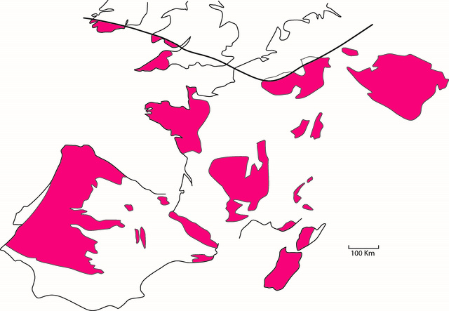
Qu’ils soient Varisques ou Hercyniens, les restes de cette chaîne de montagne constituent le socle paléozoïque de toute l’Europe de l’ouest. C’est sur ce socle que les sédiments se sont déposés au cours du Mésozoïque et de la Cénozoïque donnant naissance au bassin de Paris ainsi qu’au bassin d’aquitaine.
Varisques or Hercynian, the rests of this mountain range are the paleozoic base of all the Western Europe. It is on this base that sediments settled during the Mesozoic era and during the Cénozoïque building to the pond of Paris as well as to the pond of Aquitaine.
Le  domaine sud-armoricain est caractérisé par la présence de failles qui constituent la « zone broyée sud-armoricaine » ou «Cisaillement Sud-Armoricain».
The south-Armorican domain is characterized by the presence of faults which constitute the " south-Armorican crushed zone " or " South Armorican Cutting".
Le Cisaillement Sud-Armoricain à une forme de“Y” couché dont la base démarre au Raz de Sein et dont une branche s’étend vers l’ouest en direction d’Angers et une autre vers le sud-ouest en direction de Nantes.
South Armorican Cutting in a shape of "Y" slept. The base of which starts to the Raz de Sein and a branch of which extends westward in the direction of Angers and one other towards the southwest in the direction of Nantes.
Le sous-sol morbihannais est constitué de roches variées (sédimentaires, métamorphiques et magmatiques) La disposition des différentes roches est contrôlée par la présence de grandes failles qui coupent d’ouest en est l’ensemble du Massif Armoricain.
The morbihannais basement is constituted by varied rocks (sedimentary, metamorphic and magmatic) The arrangement(measure) of the various rocks is checked(controlled) by the presence of big weaknesses(faults) which cut from west to east the whole Armorican Massif
Avec la fin des temps hercyniens, les grandes zones de cisaillement vont transformer la croute continentale existante en mylonites. A cette époque la Bretagne subissait des tremblements de terre similaire à ceux causés par la faille de San Andreas.
With the end of Hercynian time, the big zones of cutting are going to transform the existing continental crust there mylonites. At that there was earthquakes similar to those caused by the San Andreas fault.
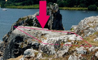
Les rochers du Ruicard sont les témoins de cette agitation qui se révèlent dans les deux types de roches qui les composent : Le granite anatectique et la pegmatite.
The rocks of Ruicard are the witnesses of this agitation which show themselves in both types of rocks who make up them: the granite anatectique and the pegmatite.
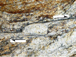
La présence de claste feldspathique à terminaison asymétrique ainsi que de stries de glissement le plan de foliation mylonitique sont révèlent le sens de cisaillement
The presence of claste feldspathique in asymmetric ending as well as of streak with sliding the plan of foliation mylonitique are reveal the sense of cutting.
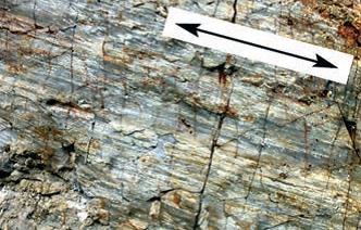
Le granite anatectique est de couleur grise relativement homogène visible sur le haut du rocher.
The granite anatectique is relatively homogeneous grey color. It is visible on the top of the rock.
La pegmatite est plus claire et présente des grains grossiers Elle est contenue dans la zone pegmatitique visible à la base du rocher.
The pegmatite is clearer and present unrefined grains It is contained in the zone pegmatitique visible at the base of the rock
Questions pour valider la découverte de la earthcache - Questions to validate the discovery of the earthcache:
Question 1 : 
Quel est l’angle d’inclinaison de la zone pegmatitique ?
question 1:
which is the angle of inclination of the zone pegmatitique ?
 Question 2 :
Sur la partie supérieure du Ruicard se trouve une plateforme rocheuse : quel est le type de roche qui la forme ?
Question 2 :
On the top of Ruicard is a rocky platform: : What kind of rock is it made of ?
Question 3 : Quelle est la forme du cisaillement sud armoricain ?
Question 3: which is the shape of the South Armorican Cutting
Question 4 : quote one or several rocks from the basement Morbihannais?
Question 4 : citez un ou plusieurs roches qui composent le sous-sol Morbihannais
Question 5 : comment s’appelle la chaîne de montagne du massif armoricain , formée à la fin du Paléozoïque (entre 450 et 300 millions d’années) ?
Question 5: what's the name of the mountain range of the Armorican massif, build in the end of the Paleozoic (between 450 and 300 million years) ?
Loguez cette cache « Found it » et envoyez-moi vos propositions de réponses soit via mon profil, soit via la messagerie geocaching.com. Je vous contacterai en cas de problème.
Log this cache and send me your answers. I Will contact you in case of problem.
Sources :
Conseil scientifique de l'environnement du Morbihan
Fiche BRE0152 dans l'Inventaire Régional du Patrimoine Géologique (IRPG)
Remerciement particulier à M Pierre Jegouzo Géologue, ancien maître de conférences à l'université de Rennes
pour son aide à la rédaction du listing ainsi que l’autorisation d’utiliser ses photos