Se site fait partie des sources des captages de Moulines. Après extraction, l'eau est stockée dans des réservoirs avant d'être acheminée par une canalisation jusqu'au château d'eau de la Guérinière, où elle est distribuée aux usagers. Les habitants de Tournebu ne boivent donc pas de l'eau d'ici.
Pour loguer cette Earthcache : Francais : Rendez-vous aux coordonnées de la cache pour trouver toute les réponses à cette earthcache.
1. Vous êtes devant le captage d'alimentation en eau potable de quelle ville ?
2. Sur les 52 captages, 12 sont aujourd'hui utilisés, combien fournissent-ils de m3 d'eau à la ville par jour ?
3. Pourquoi les autres captages ont été abandonnés ?
4. Année du début des travaux des sources de Moulines ?
5. Sur quel type de massif repose la partie ouest du Calvados ?
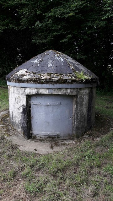
6. Dans le champs, combien y a t'il de puits de captage en eau potable, se déplacer dans le champ afin de trouver le réponse et ainsi observer ses puits ?
7. Merci de vous prendre en photo ou votre GPS autour de ce lieu, optionnelle
"Loguez cette cache "Found it" et envoyez-moi vos propositions de réponses soit via mon profil, soit via la messagerie geocaching.com (Message Center), et je vous contacterai en cas de problème."
This site is part of the sources of the Moulines catchments. After extraction, the water is stored in tanks before being transported by a pipeline to the water tower of the Guérinière, where it is distributed to the users. The inhabitants of Tournebu therefore do not drink water from here.

To log in this Earthcache: English: Go to the coordinates of the cache to find all the answers to this earthcache.

1. You are in front of the drinking water supply of which city?

2. Out of the 52 catchments, 12 are now used, how much do they provide m3 of water to the city per day?

3. Why were the other catchments abandoned?

4. Year of work begins on Moulines sources?

5. On what type of massif rests the western part of Calvados?

6. In the field, how many wells of drinking water are there, to move in the field in order to find the answer and so on observed its wells?

7. Thank you for taking a picture or your GPS around this place, optional

"Log this" Found it "cache and send me your responses either via my profile or via the geocaching.com messaging service, and I'll contact you if there's a problem."