Nous vous proposons de découvrir le sentier géologique de Ségrie. Il a été créé à l'initiative de la municipalité en partenariat avec la société CEMEX, exploitant actuel de la carrière.
Sur le parcours, vous traverserez des terrains géologiques variés qui se sont formés sur 540 millions d'années.
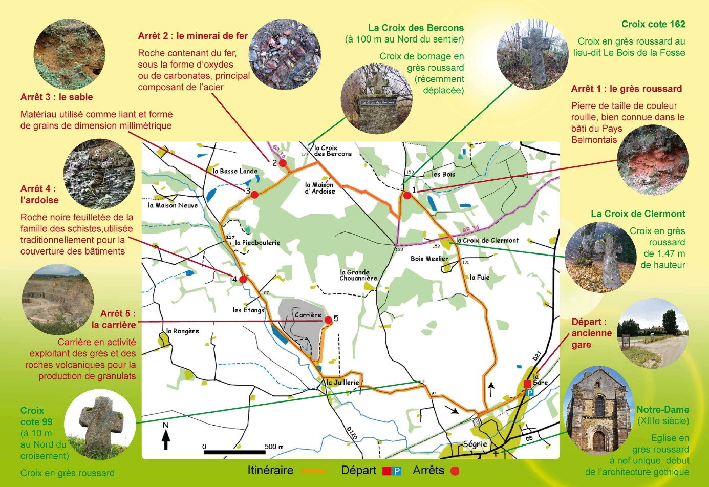
Randonnée facile, longueur 10 km, dénivelé 180 m. Recommandé à vélo ou à pied.
LE GRÈS ROUSSARD
Le grès roussard est une pierre de taille de couleur rouille, bien connue dans la Pays belmontais. On le retrouve dans de très nombreuses constructions locales du nord-ouest de la Sarthe comme les églises de Ségrie, de Saint-Christophe-du-Jambet, de Fresnay-sur-Sarthe mais aussi la cathédrale du Mans.
Il y a environ 100 millions d’années, la mer recouvre l’ensemble du Bassin parisien. Les produits d’érosion des anciennes montagnes du Massif armoricain sont transportés par les rivières, se sédimentent dans la mer, formant les Sables du Maine. Ces dépôts sableux présentent des litages obliques qui indiquent la direction des courants marins qui les ont transportés. Après le retrait de la mer à la fin du Crétacé, sous un climat tropical, ces sables vont être cimentés pour former des bancs de grès.
Le grès roussard est un matériau très utilisé dans le pays, en particulier comme pierre de taille, sous forme de moellons liés par un mortier. Les déchets de taille ont également été utilisés comme tout-venant.
L’église Notre-Dame de Ségrie et les nombreuses croix situées au bord des chemins sont des exemples locaux d'utilisation du grès roussard.
Des traces d’exploitations anciennes de cette roche sont encore visibles sur les hauteurs de la commune de Ségrie, près des Bercons. A l’exception de la carrière de La Bazoge, les dernières carrières de grès roussard ont été abandonnées vers 1950.
Les blocs de grès étaient débités et taillés sur place à l’aide de masses et de pioches.
LA EARTH CACHE
Pour valider cette earth, vous devrez vous rendre sur le site et répondre aux questions ci-dessous:
1 D'où provient la couleur du grès roussard ?
2 Comment s'appelle la période pendant laquelle la mer recouvre le bassin parisien, il y a 100 millions d'années ?
3 Quelle est l'épaisseur des dépôts sableux ?
4 Mesurer la hauteur de la croix au Waypoint 1. Quel est le matériau utilisé ?
Loguez "found it" et envoyez vos propositions de réponse par email ou message center. Nous vous contacterons en cas d'erreur.
ENGLISH VERSION
We propose to discover the Ségrie geological path. It was created by the municipality in partnership with CEMEX company, actual pit owner.
You'll walk through various geological grounds formed for 540 millions years.
Easy hiking, 10 km long, 180m climb. Prefer cycling or hiking.
* Stage 1 - Roussard sandstone - Well known construction rock in this area.
* Stage 2 - Iron ore - Rocks containing iron used to make steel.
* Stage 3 - Sands - Milimeter sized grains used as binder.
* Stage 4 - Slates - Resistant and waterprood natural material, traditionally used, since centuries, to cover building
* Stage 5 - The quarry - Extraction of quartzite sandstone and cinerite producing agregates.
THE "ROUSSARD" SANDSTONE
The "roussard" sandstone is a dressed stone, well known in the "belmontais" region. It can be seen in many local constructions in the north-west of the Sarthe, for example in the Ségrie , Saint-Christophe-du-Jambet and Fresnay-sur-Sarthe churches and also in the Le Mans Cathedral.
About 100 million years ago, the sea covered the whole of the Paris Basin. The products of the erosion from the the Armorican Massif were transported by rivers and deposited on the seabed to form the Maine sands. These sandy deposits are slanted beddings in the direction of sea currents carried them. Following retreat of the sea, at the end of the Cretaceous périod, under a tropical climate, these sands have been cemented to form sandstone banks.
The roussard sandstone is a widely used material in the region, dressed stoneparticularly as dressed stone, rubble tied with mortar. Stone-cutting waste have also been used as crusher-run aggregate.
The Ségrie Notre Dame Church and many crosses located along the roadside and tracks are local examples of the use of roussard sandstone.
Ancient extracting quarries traces of this stone are still observable in the heights of the Ségrie village, near of Bercons. Excepting the La Bazoge quarry, the last roussard sandstone quarries have been discontinued in the 1950s.
Sandstone blocks were extracted and cut on-the-spot using and mace and pick.
THE EARTH CACHE
To validate this earth cache, tou have to go to the site and aswer the following questions
1 Where does the roussard sandstone colour come from ?
2 What is the periode name durring which the sea convered the Paris Basin,100 millions years ago ?
3 How thick are the sandy deposits ?
4 Measure the crosse height at waypoint 1. Which material is it?
You can log a "found it" and send your answer using message center or email. We'll contact you if necessary.