Traduction / Translation


Le granite de Barfleur affleure sur la plate-forme littorale de l’extrémité nord-est du Cotentin, de Saint-Vaast-la-Hougue à la pointe de Barfleur à l’Est, et jusqu’au Cap Lévy et l’anse du Brick au Nord.
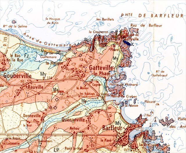

Paysage de la pointe de Barfleur
Le paysage de la pointe de Barfleur est modelé par les phénomènes d’érosion marine (deux plates-formes d’abrasion marines) et de sédimentation marine (cordon sableux)
Une plate-forme basse dépourvue de falaise vive est façonnée dans le granite de Barfleur. La morphologie du massif de granite de Barfleur est différente de celle du massif de granite de Flamanville, du même âge, situé aussi en bord de mer, mais délimité par de hautes falaises littorales (de 50 m de hauteur). La différence vient de la présence, à Flamanville, de la ceinture métamorphique de cornéennes qui borde le granite le long du littoral. Ainsi, le granite de Flamanville est protégé de l’érosion marine par les cornéennes, roches dures résistantes. Par contre, à la pointe de Barfleur, le granite se prolonge sous la mer et, le long du littoral, sa partie émergée se trouve directement soumise à l’érosion marine.
Le platier rocheux qui s’étend au pied du phare correspond à la plate-forme d’abrasion marine actuelle. Sur la ligne de rivage, le granite est recouvert par un cordon littoral sableux.
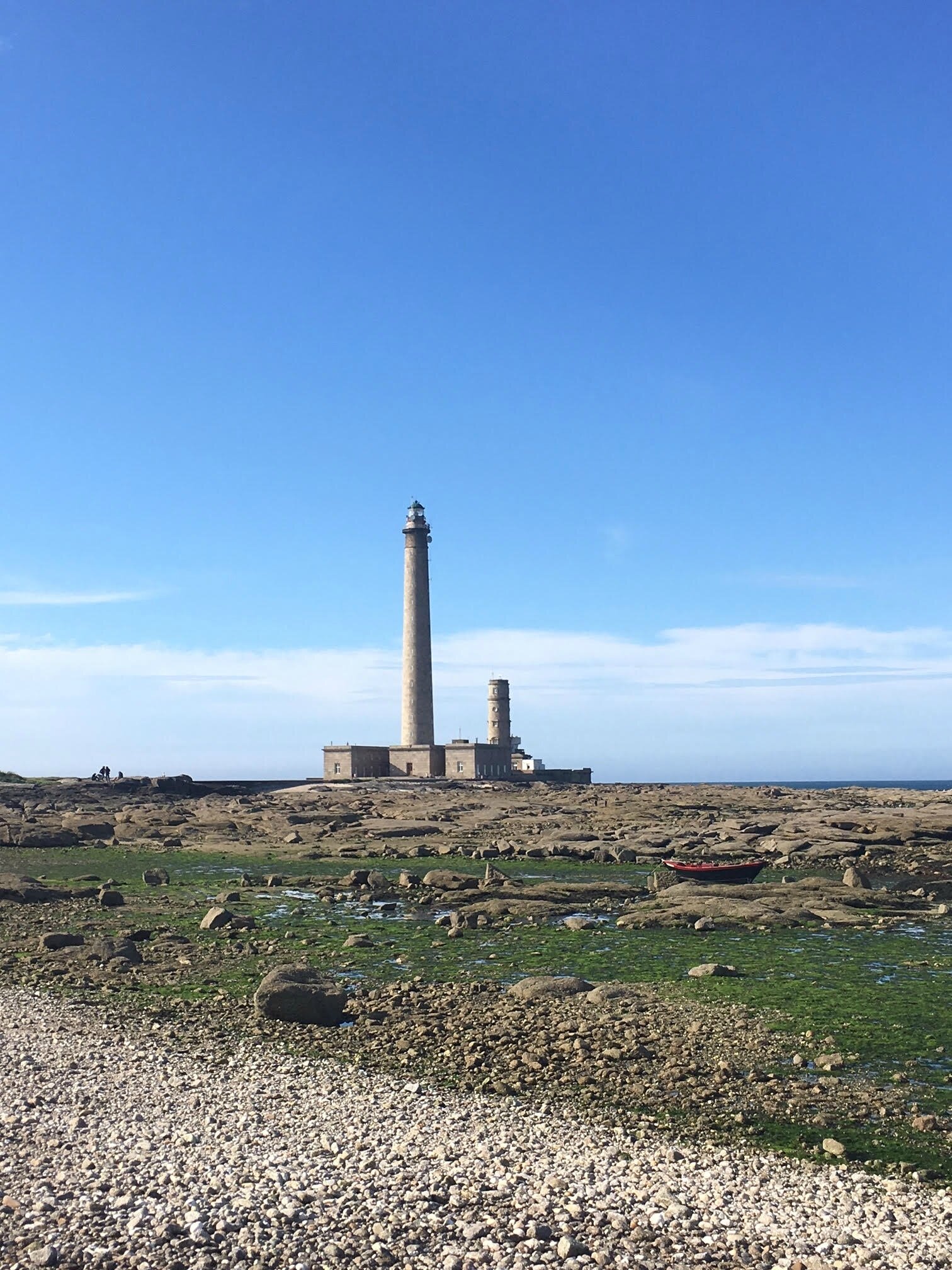
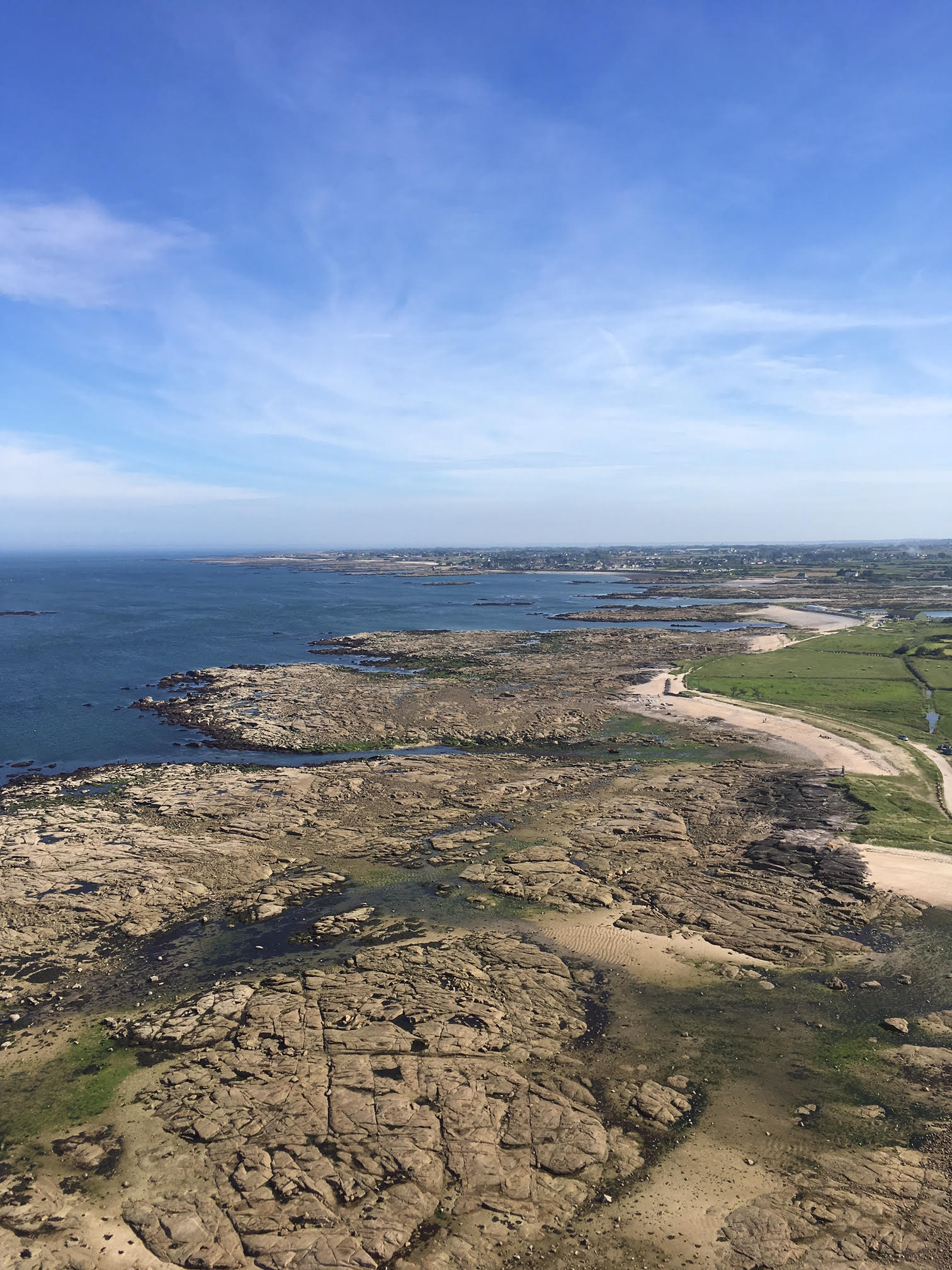
Un cordon sableux colonisé par une maigre végétation domine le granite du platier. Il sépare la plate-forme d’abrasion marine actuelle de la plate-forme d’abrasion marine ancienne.
Le Granite de Barfleur, granite intrusif de l’orogenèse varisque
Daté d’environ 320 millions d'années, le granite de Barfleur a le même âge que celui de Flamanville ; il appartient à un batholite mis en place à la fin de l’orogenèse varisque (L’orogenèse varisque est responsable de la formation de la chaîne de montagnes appelée chaîne armoricaine). C’est un granite calco-alcalin de texture porphyroïde (dont la structure présente des cristaux de grande taille au sein d'une pâte formée de cristaux invisibles à l'oeil nu).
Le « granite de Barfleur » n’affleure que dans la partie orientale du massif granitique de Barfleur ; il représenterait une venue magmatique tardive alors que le granite de Fermanville, qui affleure dans la partie occidentale du massif (cap Lévi), représenterait une venue magmatique précoce.
Le granite de Barfleur affleure largement à marée basse sur le platier rocheux de la pointe de Barfleur, au pied du phare de Gatteville.
Le granite de Barfleur contient de nombreux phénocristaux blancs rectangulaires de feldspath potassique. Entre les phénocristaux, dans le fond grenu, on distingue d’autres cristaux blancs de feldspaths, feldspaths potassiques (de couleur claires et opaques) et plagioclases sodiques (albite) (de couleur transparente) de petite taille et des cristaux gris vitreux de quartz.

Comme le granite de Flamanville, le granite de Barfleur renferme de nombreuses enclaves basiques sombres riches en minéraux ferro-magnésiens. Ces enclaves proviennent de la cristallisation d’un magma basique d’origine mantellique qui a cristallisé au sein du magma granitique.

Leur présence au sein du granite résulte de la non miscibilité des deux magmas, basique (origine mantellique) et acide (origine crustale).
Un réseau de diaclases découpe le granite du platier rocheux. (Le terme de diaclase, est utilisé pour désigner l'épisode au cours duquel une roche se fend sans que les parties disjointes s'éloignent l'une de l'autre (ne pas confondre avec la faille). Il n'y a ni déplacement (pas de rejet), ni remplissage.Les diaclases peuvent apparaître du fait de pressions dépassant les capacités de déformation de la roche (exemple : mouvements tectoniques). On peut signaler que la présence de diaclases dans une roche facilite son erosion ultérieure en permettant le passage de l’eau ou des racines de végétaux.

Filons de Pegmatite
Sur le platier rocheux de Gatteville, le granite de Barfleur est parcouru par des petits filons de pegmatite à tourmaline noire.
La pegmatite se forme à la fin de la cristallisation du magma granitique, en présence de gaz et de vapeurs enrichies en métaux d’origine profonde qui conduisent à la formation de minéraux pneumatolytiques tels que la tourmaline et le béryl.

Le granite comme matériau de construction
Le granite de Barfleur a été exploité comme matériau pour la construction et la voirie dans la région de Barfleur. Il a été utilisé pour la construction du phare de Gatteville et de ses bâtiments annexes, mais aussi pour les marches de l'église ou les murs de l'office de tourisme de Barfleur.

The Barfleur granite is exposed on the littoral platform of the northeastern extremity of the Cotentin, from Saint-Vaast-la-Hougue to the point of Barfleur in the east, and to Cap Levy and the cove of Brick in the North.
Landscape of the tip of Barfleur
The landscape at the tip of Barfleur is modeled by the phenomena of marine erosion (two marine abrasion platforms) and marine sedimentation (sandy strand)
A low deck with no sharp cliffs is formed in the Barfleur granite. The morphology of the Barfleur granite massif is different from that of the granite massif of Flamanville, of the same age, also located on the seafront, but delimited by high coastal cliffs (50 m high). The difference is due to the presence in Flamanville of the metamorphic corneal belt bordering the granite along the coast. Thus, the Flamanville granite is protected from marine erosion by the corneennes, hard rocks resistant. On the other hand, at the point of Barfleur, the granite extends under the sea and, along the coast, its emerged part is directly subject to marine erosion.
The bedrock at the foot of the lighthouse corresponds to the current marine abrasion platform. On the shoreline, the granite is covered by a sandy coastline.
A sandy cord colonized by a thin vegetation dominates the granite of the bedrock. It separates the current marine abrasion platform from the old marine abrasion platform.
Barfleur Granite, intrusive granite of the Variscan orogeny
Dated about 320 million years old, the Barfleur granite is the same age as that of Flamanville; It belongs to a batholith set up at the end of the Variscan orogeny (the Variscan orogeny is responsible for the formation of the mountain chain called the Armorican chain). It is a calco-alkaline granite of porphyroid texture (the structure of which has large crystals within a paste formed of crystals invisible to the naked eye).
The "Barfleur granite" appears only in the eastern part of the granite massif of Barfleur; It would represent a late magmatic occurrence while the granite of Fermanville, which is exposed in the western part of the massif (Cape Levi), would represent a precocious magmatic coming.
The Barfleur granite is largely exposed at low tide on the rocky platter of Barfleur Point, at the foot of the Gatteville lighthouse.
Barfleur granite contains many rectangular white phenocrysts of potassium feldspar. Between the phenocrystals there are other white crystals of feldspars, potassic feldspars (light colored and opaque), and small-sized (albite) (transparent color) plagioclases and quartz glassy gray crystals.
The feldspar phenocrysts have been oriented in the direction of flow of the granite magma during the placement of the latter.
Like the granite of Flamanville, Barfleur's granite contains many dark basic enclaves rich in ferro-magnesian minerals. These enclaves come from the crystallization of a basic magma of mantle origin that crystallized within the granite magma.
Their presence within the granite results from the immiscibility of the two magmas, basic (mantle origin) and acid (crustal origin).
A network of diaclases cuts the granite from the rocky flat. (The term "diaclase" is used to denote the episode in which a rock cracks without disjoining the parts separated from each other (not to be confused with the fault). Displacement (no rejection) or filling.Diaclases may appear due to pressures exceeding the deformation capacities of the rock (eg tectonic movements). It can be noted that the presence of diacases in a rock facilitates its subsequent erosion by allowing the passage of water or roots of plants.
Pegmatite threads
On the rocky flat of Gatteville, the granite of Barfleur is traversed by small veins of black tourmaline pegmatite.
Pegmatite forms at the end of the crystallization of the granite magma in the presence of gases and vapors enriched with metals of deep origin which lead to the formation of pneumatolytic minerals such as tourmaline and beryl.
Granite as building material
The Barfleur granite was used as a material for construction and roads in the Barfleur region. It was used for the construction of the lighthouse of Gatteville and its ancillary buildings, but also for the steps of the church or the walls of the tourist office of Barfleur.
► Sources
http://www.etab.ac-caen.fr/discip/geologie/
http://infoterre.brgm.fr/viewerlite/MainTileForward.do#
http://www.geowiki.fr
Wikipedia
Google
QUESTIONS
La lecture attentive du descriptif de la cache, ainsi qu'une observation des éléments de terrain et un peu de déduction sont normalement suffisants pour répondre aux questions de cette EarthCache.
A careful reading of the description of the cache, as well as observation of terrain features and some deduction is usually sufficient to answer questions of this EarthCache.
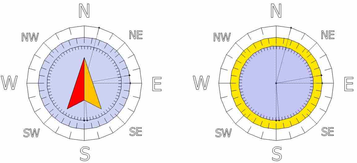
Pour répondre aux questions, vous aurez besoin d'un mètre mesureur et d'une boussole (ou de cette fonction de votre GPS ou smartphone)
To answer the questions, you will need a measuring tape and a compass (or this function on your smartphone or GPS)
Vous aurez à mesurer l'orientation des éléments, avec une boussole ou avec votre GPS en mode compas, en notant le nombre de degrés à droite du Nord (les mesures peuvent donc aller de N 0° (Nord zéro degré) à N 179° (Nord cent soixante dix neuf degrés). C’est ce que l’on appelle la notation « main droite ».
You will have to measure the orientation of the elements, with a compass or with your GPS in compass mode, noting the number of degrees to the right of the North (the measurements can therefore range from N 0 ° (North zero degree) to N 179 ° (North one hundred and seventy-nine degrees.) This is called the "right hand" notation.


WP1 : Question 1 - Quel élément décrit ci-dessus pouvez-vous observer sur le rocher de la photo WP1 ? Décrivez-le (taille, couleur, orientation par rapport au nord)
WP2 : Question 2 - Quelle est largeur maximum du fond de la diaclase que vous pouvez observer sur la photo WP2 ? Quel phénomène a pu et peut encore participer à l'érosion de cette diaclase ?
WP3 : Question 3 - Quels éléments décrits ci-dessus pouvez-vous observer sur le rocher de la photo WP3 ? Quelle est son orientation par rapport au nord ?
WP 4 : Question 4 - Quel élément décrit ci-dessus pouvez-vous observer sur la pierre de la photo WP4 ? Décrivez-le (taille (largeur / hauteur), couleur, aspect).
WP1: Question 1 - Which element described above can you observe on the rock of the photo WP1? Describe it (size, color, orientation in relation to the north)
WP2: Question 2 - What is the maximum width of the bottom of the diaclase that you can see in the photo WP2 ? What phenomenon has been and can still contribute to the erosion of this diaclase?
WP3: Question 3 - Which elements described above can you observe on the rock of the WP3 photo? What is its orientation in relation to the north ?
WP 4: Question 4 -Which element described above can you observe on the stone of the WP4 photo? Describe it (size (width / height), color, aspect).
Vous pouvez vous loguer cette cache « Found it » sans attendre ma confirmation, mais vous devez m’envoyer vos propositions de réponses par mail en même temps soit via mon profil, soit via la messagerie geocaching.com (Message Center), et je vous contacterai en cas de problème.
Les logs enregistrés sans réponses seront supprimés.
Une photo de vous ou de votre GPS devant le phare de Gatteville serait la bienvenue, mais n'est pas obligatoire
You can log in this "Found it" cache without waiting for my confirmation, but you must send me your responses by email at the same time either via my profile or via messaging geocaching.com (Message Center) Contact in case of problems.
Logs saved without answers will be deleted.
A photo of you or your GPS in front of the Gatteville lighthouse would be welcome, but is not mandatory
Rappel concernant les « Earthcaches »: Il n'y a pas de conteneur à rechercher ni de logbook à renseigner. Il suffit de se rendre sur les lieux, de répondre aux questions ci-dessus et de nous renvoyer les réponses.
Reminder on "Earthcaches" There is no container or logbook to find information. Simply visit the site, to answer questions above and send us the answers.
Traduction / Translation

Bonnes observations.