Situé à l'extrémité sud-occidentale du domaine centre-armoricain, aux confins du Finistère et du Morbihan, le territoire couvert par la feuille Gourin est dominé par le relief linéamentaire des Montagnes-Noires. L'organisation structurale de ce secteur, en bandes parallèles orientées au N 800 E, est héritée d'une déformation par cisaillement transcurrent ductile dextre, d'âge fini-carbonifère.
Located at the south-western end of the center-armorican domain, on the borders of Finistere and Morbihan, the territory covered by the Gourin leaf is dominated by the lineamentary relief of the Black Mountains. The structural organization of this sector, in parallel strips oriented at N 800 E, is inherited from dextral ductile transcurrent shear deformation, of finite-carboniferous age.
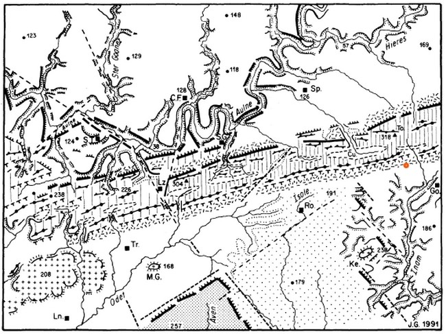
L'ensemble des formations de la feuille Gourin est agencé en une série de bandes parallèles, orientées au N 80 DE et qui, en l'absence de répétition tectonique par plissement ou contact anormal, présentent des âges croissant du Namurien, au Nord, au Briovérien, vers le Sud.
The set of formations of the Gourin leaf is arranged in a series of parallel strips oriented at N 80 DE and which, in the absence of tectonic repetition by folding or abnormal contact, have increasing ages from the Namurian in the north to Briovérien, to the south.
Poudingue de Gourin
L'identification du poudingue de Gourin sur le terrain s'opère par l'observation, à la surface des champs, de galets centimétriques de quartz blanchâtres, très arrondis. La cartographie approximative de ces épandages révèle l'existence de plusieurs bandes discontinues, d'une longueur inférieure au kilomètre et d'une largeur n'excédant pas 50 m.
The identification of the Gourin pudding on the ground is effected by the observation, on the surface of the fields, of centimetric pebbles of whitish quartz, very rounded. The approximate mapping of these spreads reveals the existence of several discontinuous bands, less than one kilometer long and not more than 50 m wide.
L'organisation interne du Poudingue de Gourin a pu être partiellement appréhendée dans l'ancienne carrière de Guernangoué, au Nord-Est de Roudouallec, où l'on observe une masse conglomératique homogène, à galets de quartz non jointifs de forme arrondie et de taille centimétrique. Le poundigue de Gourin est une roche sédimentaire détritique formée pour 50% au moins d'éléments arrondis (galets) de diamètre supérieur à 2mm, classe des rudites, liés par un ciment.
Ceux-ci sont emballés dans une matrice argileuse blanchâtre, très altérée, où figurent également quelques fragments de quartzites noirâtres ainsi que des clastes argileux identiques à la matrice. L'ensemble des éléments figurés ne matérialisent aucune stratification apparente, pas plus qu'ils ne présentent d'imbrication préférentielle.
The internal organization of the Poudingue de Gourin may have been partially apprehended in the former quarry of Guernangoué, northeast of Roudouallec, where a homogeneous conglomerate mass with non-jointed quartz pebbles of rounded shape centimeter. Gourin poundigue is a detrital sedimentary rock formed for at least 50% of rounded elements (pebbles) of diameter greater than 2mm, class of rudites, bound by cement.
These are packed in a whitish, highly altered clay matrix, which also includes some fragments of blackish quartzites and clay clays identical to the matrix. All the elements shown do not show any apparent stratification, nor do they exhibit any preferential nesting.

De tels dépôts conglomératiques, à très grande maturité de composition et de texture, caractérisent l'ensemble des séries terrigènes briovériennes du domaine armoricain oriental où leur origine glaciaire y est classiquement admise.
Such conglomerate deposits, with a very high maturity of composition and texture, characterize all the brio-rerian terrigenous series of the Eastern Armorican domain where their glacial origin is classically accepted.
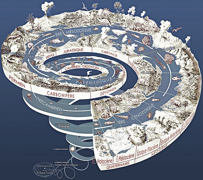
Certains géologues bretons et normands considèrent le poudingue de Gourin comme antécambrien (ou précambrien, la plus longue période sur l'échelle des temps géologiques, puisqu'elle s'étend de la formation de la Terre, il y a environ 4,560 milliards d'années, à l'émergence d'une abondante faune d'animaux à coquille rigide il y a 541 milliards d'années) ou, depuis 1951, comme infracambrien, sans d'ailleurs que la position exacte du niveau occupé par le poudingue soit clairement définie (Graindor 1954).
D'autres chercheurs prennent le poundigue de Gourin comme limite inférieure de la série cambrienne. « La limite entre Cambrien et le Briovérien, tracée jusqu'ici en Bretagne sous le poundigue de Montfort se trouve par suite, devoir être déplacée pour passer sous le poundigue de Gourin » (Barrois et Pruvost, 1931).
Some Breton and Norman geologists consider the Gourin pudding as antecambrian (or Precambrian), the longest period on the geological time scale, since it extends from the formation of the Earth, about 4.560 billion years ago , The emergence of an abundant fauna of animals with rigid shells 541 billion years ago) or, since 1951, as an infracambrian, without, moreover, the exact position of the level occupied by the pudding is clearly defined (Graindor 1954).
Other researchers take the Gourin pound as the lower limit of the Cambrian series. « The boundary between the Cambrian and the Brioverian, hitherto traced in Brittany under the pound of Montfort, is consequently to be displaced to pass under the pound of Gourin » (Barrois and Pruvost, 1931).
Pour valider cette earthcache
Petit rappel : pour une earthcache il n'y a pas de boîte à trouver ! Il vous suffit de répondre aux questions posées ci-dessous !
Question 1 : aux coordonnées de la cache vous trouverez un grand bloc qui comporte des incrustations de poudingue de Gourin, quelles sont les 2 couleurs prédominantes de ce bloc ? Quelle proportion de poudingue de Gourin pouvez-vous observer sur la face avant de ce bloc ? 10%, 20% ou 50%
Question 2 : aux waypoint n°2 vous trouverez le bloc ci-dessous en photo, quelles sont les 2 couleurs prédominantes de ce bloc ? En précisant la couleur des galets et la couleur du ciment .
Question n°3 : Enfin quelle est la taille du petit galet de quartz entouré de rouge sur la photo ?

Vous pouvez loguer votre découverte et dans le même temps m'envoyer vos réponses par message center ou via mon profil. Je vous recontacterais en cas de soucis dans vos réponses.
To validate this earthcache
Small reminder: for an earthcache there is no box to find! Just answer the questions below!
Question 1: at the coordinates of the cache you will find a large block that includes inlays of Gourin pudding, what are the 2 predominant colors of this block? What proportion of Gourin's pudding can you see on the front of this block? 15%, 25% or 50%
Question 2: In waypoint n ° 2 you will find the block below in picture, what are the 2 predominant colors of this block? By specifying the color of the pebbles and the color of the cement.
Question 3: Finally, what is the size of the small quartz roller surrounded by red in the photo?
You can log your discovery and at the same time send me your answers by message center or via my profile. I will contact you if you have any concerns in your answers.