
O Vulcanismo é uma manifestação do geodinamismo interno, constituindo o mecanismo central da evolução do palneta. Os vulcões oferecem um espéctaculo por vezes trágico, mas deslumbrante e interessante para o conhecimento do interior do nosso planeta.
Uma erupção vulcânica é caracterizada, geralmente, pela extrusão de materiais no estado de fusão ígnea, a lava, pela emissão de gases e, muitas vezes, pela explusão de materiais sólidos de dimensões variadas. A lava corresponde ao magma que já experimentou desgaseificação e outras alterações durante a ascenção.
As manifestações vulcânicas são apenas a exteriorização de fenómenos complexos que ocorrem no interior do nosso planeta. As estruturas terrestres onde ocorrem esses fenómenos constituem um aparelho vulcânico.
De acordo com alguns aspectos da conduta emissora podem considerar-se dois tipos fundamentais de vulcanismo: Vulcanismo do Tipo Central e Vulcanismo do Tipo Fissural. Nesta earthcache iremos abordar apenas o Vulcanismo do Tipo Central.
No Vulcanismo do Tipo Central forma-se uma conduta tubular chamada chaminé vulcânica, por onde ascendem os materiais até à superfície.
Experiências de laboratório e dados geofísicos têm sugerido que o magma pode formar-se a profundidades que oscilan entre os 70km e cerca de 200km, devido à fusão parcial das rochas.
Devido às elevadas temperaturas o magma é menos denso do que as rochas e sobe, acumulando-se em espaços no interior da crusta que constituem as câmaras magmáticas que podem situar-se a diferentes profundidades e intercomunicar. As câmaras magmáticas são delimitadas são delimitadas por rochas da crusta, rochas encaixantes, sobre as quais o magma exerce influência devido à alta temperatura a que se encontra.
Quando há um aumento da pressão na câmara magmática, o magma é forçado a subir através de fendas das rochas para câmaras mais superficiais e, posteriormente, destas até à superfície através da chaminé. O aumento de pressão numa câmara pode ser provocado pela chegada de magma proveniente de reservatórios mais profundos. a subida de pressão pode provocar a fractura do tecto da câmara ou aumentar as fracturas já existentes. O magma enfrenta então uma descompressão, os gases dissolvidos tornam-se menos solúveis formando bolhas que favorecem a ascensão.
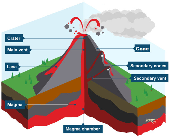
A acumulação de materiais expelidos na superfície origina uma estrutura cónica designada por cone principal. A parte da chaminé termina, muitas vezes, numa depressão afunilada no topo do cone vulcânico, chamada cratera.
É frequente haver emissões através de fendas que se abrem nos flancos do cone. essas aberturas designam-se crateras secundárias e os materiais por elas expelidos formam cones secundários, sendo estes alimentados por chaminés secundárias.
Em determinadas situações podem formar-se caldeiras no topo dos vulcões. As caldeiras têm uma forma grosseiramente circular, paredes íngremes e, geralmente, alguns quilómetros de diâmetro. As caldeiras de subsidência formam-se devido ao afundamento da parte central do vulcão, após fortes erupções, em que grande quantidade de materiais é rapidamente expelida, ficando um vazio na câmara magmática. A existência de fracturas circulares e o peso das camadas superiores provocam o colapso do teto da câmara, o que ocasiona o seu afundamento. Há, no entanto caldeiras com outras origens, como por exemplo, devidas, somente, a grandes explosões.
É frequente, após as erupções vulcânicas, quando os vulcões deixam de estar em actividade, que as crateras ou as caldeiras sejam preenchidas por águas da chuva, do degelo ou do solo, formando lagoas.
Noutras situações a lava solidifica mesmo dentro da chaminé, formando agulhas vulcânicas, que podem mais tarde ficar a descoberto, por processos naturais.
Para reforçar os conceitos anteriormente descritos segue a seguinte imagem:

A Cache
A Cache tem por principal objectivo elucidar os geocachers não só acerca do Vulcanismo como também da herança vulcânica da Ilha da Madeira, nomeadamente o Pico da Atalaia, um local único e de rara beleza, com um enorme potencial geológico. A todos os interessados em realizar esta earthcache recomendo, que se dirijam às coordenadas indicadas (coordenadas estas que se situam no mar) pois só desta forma conseguiram ter a total noção do aparelho vulcânico e assim poderem responder às perguntas por mim colocadas. Aconselho a leitura atenta da listing antes de abordar esta earthcache, pois a leitura antecipada da mesma e a observação das imagens fornecidas, facilita à obtenção do conhecimento necessário para responder as questões seguintes.
1 - O que entende por Vulcanismo do Tipo Central?
2 - Que estruturas do aparelho vulcânico consegue identificar olhando na direcção 345º?
Adicionalmente, gostaria de vos pedir que associassem ao vosso log, fotos da vossa visita a esta earthcache, no entanto segundo as guidelines as mesmas são opcionais.
| I have earned GSA's highest level: |
 |

Volcanism is a manifestation of internal geodynamism, constituting the central mechanism of the evolution of the palnet. The volcanoes offer a spectacle sometimes tragic, but dazzling and interesting for the knowledge of the interior of our planet.
A volcanic eruption is generally characterized by the extrusion of materials in the igneous fusion state (lava) by the emission of gases and, often, by the explosion of solid materials of varying dimensions. The lava corresponds to the magma which has already experienced degassing and other changes during ascension.
Volcanic manifestations are only the manifestation of complex phenomena occurring within our planet. The terrestrial structures where these phenomena occur constitute a volcanic apparatus.
According to some aspects of the emitting behavior, two fundamental types of volcanism can be considered: Central Type Volcanism and Fissural Type Volcanism. In this earthcache we will only approach the Central Type Volcanism.
In Central Type Volcanism is formed a tubular conduit called volcanic chimney or vent, where the materials ascend to the surface.
Laboratory experiments and geophysical data have suggested that magma can form at depths ranging from 70km to about 200km due to the partial melting of the rocks.
Due to the high temperatures the magma is less dense than the rocks and rises, accumulating in spaces inside the crust that constitute the magmatic chambers. Which can be located at different depths and intercommunicate. The magmatic chambers are delimited by rocks of the crust, on which the magma exerts influence due to the high temperature.
When there is an increase in pressure in the magma chamber, the magma is forced up through cracks from the rocks to more shallow chambers, and then from these to the surface through the chimney. The increase in pressure in a chamber can be caused by the arrival of magma from deeper reservoirs. The rise in pressure can lead to fracture of the ceiling of the chamber or increase existing fractures. The magma then faces a decompression, the dissolved gases become less soluble forming bubbles that favor the ascent.
The accumulation of expelled materials on the surface gives rise to a conical structure designated as the main cone. The part of the chimney often ends in a tapered depression at the top of the volcanic cone, called the crater.
Is often to occur emissions through slits that open on the flanks of the cone. These openings are called secondary craters and the materials that are expelled form secondary cones, these are powered by secondary chimneys or secondary vents.
In certain situations calderasmay form on top of volcanoes. The calderas have a roughly circular shape, steep walls and, generally, a few kilometers in diameter. The subsidence calderas are formed due to the sinking of the central part of the volcano, after strong eruptions, in which a great amount of material is quickly expelled, leaving a void in the magmatic chamber. The existence of circular fractures and the weight of the upper layers causes the collapse of the ceiling of the chamber, which causes its sinking. There are, however, calderas with other origins, for example, due only to large explosions.
It is often that after volcanic eruptions, when volcanoes cease to be active, that craters or calderas may be filled by rainwater, forming lakes.
In other situations the lava solidifies even inside the chimney, forming volcanic needleswhich can later be discovered by natural processes.
The following image exemplifies the previously concepts.
The Cache
The Cache has as main objective, the elucidation of the geocachers not only about Volcanism but also about the volcanic heritage of Madeira, in particular about the Atalaia's Peak, a unique and rare beauty, with an enormous geological potential. If you are interested in realizing this earthcache I recommend that you go to the indicated coordinates (these coordinates are in the sea) because only by this way, you will be able to have the total preception about the volcanic apparatus, and thus, to be able to answer the questions. I advise careful reading of the listing before approaching this earthcache, since the anticipated reading of it and the observation of the provided images, facilitates to obtain the knowledge necessary to answer the following questions.
1 - What you mean by Central Type Vulcanism?
2 - Which structures of the volcanic apparatus can you identify looking in the direction 345º?
In addition, you can associate photos to your log, however according to the guidelines the photos are optional.
| I have earned GSA's highest level: |
|