Le Volcan Cantalien : L'éruption du Cantal
Le Massif Cantalien est le plus vaste stratovolcan d’Europe. L’édification d’un tel massif volcanique s’est opéré sur une période de plusieurs millions d’années (des éruptions qui ont eu lieu de –13 à –3 millions d’années), alternant des phases d’activité intense et des phases plus calmes, voire de sommeil. Ainsi les matériaux issus des différentes éruptions successives se sont empilés en strates, c’est pourquoi on parle de stratovolcan.
D’un diamètre de 70 km et d’une superficie de 2700 km², son imposante taille est formée d’un cône central stratifié (alternance de coulées de lave et de tephras) et d’un piémont périphérique pouvant recouvrir plusieurs milliers de km². Le stratovolcan cantalien a pu atteindre 3500 à 4000 mètres d’altitude selon certaines hypothèses.
Morphologiquement, cet édifice majeur se distingue en deux secteurs :
- une zone centrale, montagneuse, au relief accidenté, dont les principaux sommets sont le Plomb du Cantal (1855 m), le Puy du Rocher (1813 m), le Peyre Arse (1806 m), le Puy Brunet (1806 m), le Puy Mary (1787 m) et le Puy Griou (1690 m),
- une zone périphérique constituée de plateaux, appelés «planèzes», à faible pente externe, limités par des vallées larges et profondes.
Le stratovolcan du Cantal s'est édifié par étapes, pour l'essentiel entre 13 et 2 millions d’années, sur le substratum granitique et métamorphique du Massif central. .
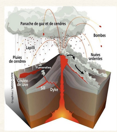
Ces différentes phases de construction et de destruction de l’édifice volcanique sont déterminées par les géologues grâce à l’observation de plusieurs couches de roches magmatiques distinctes. Cette édification de la montagne en strates identifiables est à l’origine de l’appellation « stratovolcan » pour désigner les Monts du Cantal.
On distingue plusieurs grandes périodes dans l’activité volcanique :
1) Les premières éruptions basaltiques (13 à 7 Ma) : coulées de nature basaltique et basanitique et parfois associées à des projections stromboliennes
2) L’édification du stratovolcan (10 à 6,5 Ma) : les éruptions de cette période ont été très intenses et ont accumulé en hauteur une quantité très importante de matériaux volcaniques.
3) L’effondrement du stratovolcan : Entre -7,4 et -7,2 Ma, trois avalanches de débris se sont produites

4) Des intrusions phonolitiques (entre 7 et 6,5 Ma) : apparition d’un volcanisme de nature phonolithique, localisé en deux principaux points du Massif.
5) Les basaltes supracantaliens (entre 7 et 2 Ma) : des coulées de lave fluide vont niveler le sol en créant de vastes étendues aplanies que l’on nomme aujourd’hui planèzes
6) L'érosion glaciaire et post-glaciaire de l'édifice volcanique (entre 120 000et 10 000 ans) : les glaciers ont remodelé l'édifice volcanique en façonnant un réseau hydrographique dont la forme radiale actuelle naît au cœur de l'édifice.
Je vous propose en 3 earths, de vous intéresser à cette histoire du volcanisme cantalien, plus précisément d’entrer dans les détails concernant :
1- Aux hauts Plateaux et les coulées de basaltes
2- A l’éruption du Cantal et l’histoire de ses différentes phases
3- Aux hauts sommets formés par les laves visqueuses.
(2) L'éruption du Cantal
Les panneaux d’information aux coordonnées vont vous fournir les informations nécessaires pour répondre aux questions.
1- Quelles sont les 4 phases de l’histoire du Stratovolcan du Cantal qui sont présentées ici?
2- Quelles sont les 4 grandes familles de volcans en fonction de leur dynamisme ?
3- De quels types (au pluriel) était l’éruption du Cantal ?
4- Sur quelle planèze êtes-vous ?
Optionnel mais apprécié : Prenez-vous en photo ou votre GPS dans ce lieu particulier
"Loguez cette cache "Found it" et envoyez-moi vos propositions de réponses soit via mon profil, soit via la messagerie geocaching.com (Message Center), et je vous contacterai en cas de problème."
ENGLISH VERSION
The "Massif Cantalien" is the largest stratovolcano in Europe. The construction of such a massive volcanic mass has taken place over a period of several million years (eruptions that have occurred from -13 to -3 million years), alternating phases of intense activity and Calmer phases, even sleep. Thus the materials resulting from different successive eruptions have stacked in strata, which is why we speak of stratovolcano.
It is 70 km in diameter and has an area of 2700 km². Its imposing size is formed by a central laminated cone (alternating lava flows and tephras) and a peripheral piedmont covering several thousand km². The Cantalian stratovolcano was able to reach 3500 to 4000 meters of altitude according to certain hypotheses.
Morphologically, this major building is distinguished in two sectors:
- a central, mountainous zone with a rugged terrain, whose main summits are the Plomb du Cantal (1855 m), the Puy du Rocher (1813 m), the Peyre Arse (1806 m), the Puy Brunet (1806 m) The Puy Mary (1787 m) and the Puy Griou (1690 m),
- a peripheral zone constituted by plateaus, called "planèzes", with a small external slope, limited by wide and deep valleys.
The stratovolcano of Cantal was built in stages, mostly between 13 and 2 million years ago, on the granite and metamorphic bedrock of the Massif Central .
These different phases of construction and destruction of the volcanic edifice are determined by geologists through the observation of several layers of distinct magmatic rocks. This edification of the mountain in identifiable strata is at the origin of the name "stratovolcan" to designate the Monts du Cantal.
There are several major periods in volcanic activity:
1) The first basaltic eruptions (13 to 7 Ma) : castings of basaltic and basantic nature and sometimes associated with strombolian projections
2) The construction of the stratovolcano (10 to 6.5 Ma) : the eruptions of this period were very intense and accumulated in height a very important quantity of materials Volcanic.
3) Stratovolcano collapse : Between -7.4 and -7.2 Ma, three avalanches of debris occurred
4) Phonolithic intrusions (between 7 and 6.5 Ma) : phonolithic volcanism, located in two main points of the Massif.
5) The supracantalian basalts (between 7 and 2 Ma) : flowing lava flows will level the ground creating vast areas that are now called Planèzes
6) Glacial and post-glacial erosion of the volcanic edifice (between 120,000 and 10,000 years ago): glaciers have reshaped the volcanic edifice by shaping a network The current radial shape of which originates in the heart of the building.
>I propose to you in 3 earths, to be interested in this history of the volcanism Cantalien, more precisely to enter in the details concerning:
1- To the Highlands and the basalt flows
2- In the eruption of Cantal and the history of its different phases
3- The high summits formed by the viscous lavas.
(2) The eruption of Cantal
The information panels at the coordinates will provide you with the information needed to answer the questions.
1- What are the 4 phases of the history of the Stratovolcan of Cantal that are presented here?
2- What are the 4 major families of volcanoes according to their dynamism?
3- Of what types (in the plural) was the eruption of Cantal?
4- On which planeze are you?
Optional but appreciated: Take a picture or GPS in this particular place
"Log in this cache" Found it "and send me your replies either via my profile, or via the geocaching.com messaging (Message Center), and I will contact you if there is a problem."