Pour compléter la série des earthcaches de Trégastel,
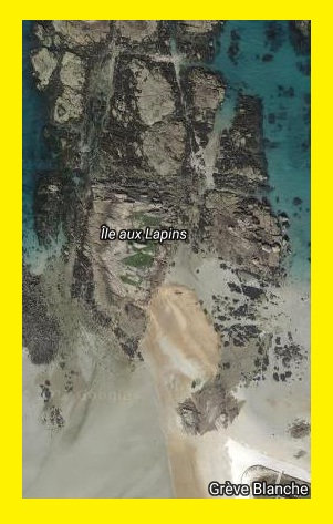
voici Tombolo des Lapins
Un tombolo est un cordon littoral de sédiments reliant deux étendues terrestres, entre une île ou un îlot (le Dé de Trégastel) et la côte (continent ou une autre île). Le dépôt sédimentaire (sable fin, sable grossier, petits moyens gros galets, déchets ...) est généralement mis en place par la réfraction du train de vagues due à l'île : celle-ci protège la zone située entre elle et l'autre étendue terrestre, provoquant le dépôt des sédiments où les vagues se rencontrent. Certains peuvent être relativement mobiles, ou au contraire, stables. Plus la forme du tombolo est rectiligne, plus il démontre la régularité des influances marines. Plus les courants et amplitudes de marée sont forts, plus le tombolo sera mouvant et serpentera entre ses deux points d'attache appelés isthmes (partie la plus étroite du tombolo).
Deux phénoménes sont observables sur les tombolos, l'influence des courants irréguliers marins et le relief géologique du site. Plus ce relief est plat, plus le tombolo sera constitué de gros grains que la force des marées bretonnes permettront de propulser sur les crétes des tombolos.
Le développement du tombolo est lié aux phénomènes d'érosion du littoral proche : Chaque fois que la quantité des sédiments disponibles sur le rivage dépasse le volume des sédiments que les vagues et les courants littoraux peuvent déplacer, le processus d'accumulation dite : accrétion l'emporte sur celui de l'érosion.
 Cette géocache est une earthcache, il n'y a donc pas de boite contenant un logbook. Pour valider cette earthcache, vous devez répondre aux questions ci dessous, m'envoyez vos réponses par message géocaching en indiquant GC74Y09. Puis loguez votre found it et je vous contacterai en cas de probléme ... Cette géocache vous invite devant des formes impressionnantes de granite rose à Trégastel. Elle nécessite de se rendre sur le waypoint fréquemment recouvert par la marée, soyez donc vigilant et ne négligez ni horaires ni coéfficients !
Question 1 : Quelle est la forme du tombolo entre les deux isthmes ?
Question 2 : Sur la créte du tombolo, quels caractéristiques ont les grains de sable ?
Question 3 : De chaque coté de la créte, quelle autre sorte de sable trouvez vous ?
Question 4 : Que pouvez vous en déduire ici sur l'importance du relief et les courants marins ?
 Bon Géocaching en Trégor
--------------------------------Traduit par google du francais à l'anglais-------------------------------
To complete the series of earthcaches of Trégastel,
here is Tombolo des Lapins
A tombolo is a coastal line of sediments connecting two land areas, between an island or an island (the Trégastel dice) and the coast (continent or another island). The sedimentary deposit (fine sand, coarse sand, small pebbles, rubbish ...) is usually set up by the refraction of the wave train due to the island, which protects the area between it and the island. another land area, causing deposition of the sediments where the waves meet. Some may be relatively mobile, or on the contrary, stable. The more rectilinear the shape of the tombolo, the more it demonstrates the regularity of marine influences. The stronger tidal currents and amplitudes, the faster the tombolo will be, and the more it will snake between its two points of attachment called isthmus (the narrowest part of the tombolo).
Two phenomena are observed on tombolos, the influence of irregular marine currents and the geological relief of the site. The flattened the relief, the more the tombolo will be made of big grains that the force of the Breton tides will allow to propel on the crests of the tombolos.
The development of tombolo is related to near-coastal erosion phenomena: Whenever the amount of sediments available on the shore exceeds the sediment volume that waves and shore currents can move, the accumulation process known as accretion l the erosion.
This geocache is an earthcache, so there is no box containing a logbook. To validate this earthcache, you must answer the questions below, send me your answers by geocaching message indicating GC74Y09. Then log your found it and I will contact you in case of problem ...
This geocache invites you to impressive forms of pink granite in Trégastel. It requires to go on the waypoint frequently covered by the tide, so be vigilant and neglect neither schedules nor coefficients!
Question 1: What is the shape of the tombolo between the two isthmuses?
Question 2: What characteristics do sand grains have on the tombolo crest?
Question 3: On each side of the Crete, what other kind of sand do you find?
Question 4: What can you deduce here about the importance of the relief and the sea currents?
Good Geocaching in Trégor