TP-EC: La tourbière du Peuil
[FR] Qu'est-ce qu'une tourbière ?
Une tourbière est une zone humide, colonisée par la végétation.
Des conditions écologiques particulières ont permis la formation d’un sol constitué d’un dépôt de matière organique mal ou non décomposée (la tourbe).
[EN] What is a peatland ?
A peatland is a wetland, colonized by vegetation.
Particular ecological conditions have allowed the formation of a soil consisting of a deposition of poorly or undecomposed organic matter (peat).
[FR] La tourbière du Peuil
La tourbiere du Peuil est une des rares zones humides du Vercors ainsi que l’une des dernières tourbières d’altitude à sphaigne en Isère
Le Vercors (essenciellement calcaire) n’est pas de nature à favoriser ce genre de lieux.
Cette tourbière contient un écosytème avec des espèces végétales et animales rares.
[EN] Peatland of Peuil
Peatland of Peuil is one of the rare wetlands of the Vercors and one of the last sphagnum peat bogs in Isère
The Vercors (limestone) is not likely to favor this kind of places.
This bog contains an ecosystem with rare plant and animal species.
[FR] Histoire de la tourbière du Peuil
L'origine de cette tourbière remonte à plus de 200000 ans
Etape 1 : Il y a 200000 ans, pendant l'épisode glaciaire du Riss.
Apres érosion du flan (marneux) de la falaise du Vercors par les eaux sous glaciaires et le "glacier de l'Isere" lui même, lorsque le glacier s'est retiré, il a laissé la roche supérieure en surplomb.
Cette roche s'est effondrée et à constituée le plateau du Peuil.
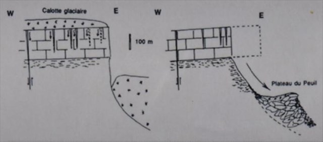
Etape 2 : Il y a 20000 ans, pendant un nouvel épisode glaciaire (Wurm).
Un nouveau glacier se forme (plus petit) et constitue des moraines latérales.
Une crête se forme en particulier sur son côté Est donnant au plateau une forme de cuvette.
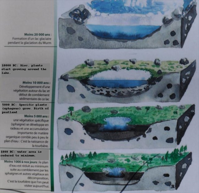
Etape 3 : Lors de la fonte du glacier, un lac se forme dans la cuvette du Peuil.
Progressivement, ce lac se comble d'argile, et est colonnisé par des végétaux.
Quand les sphaignes se développent, il se comble petit à petit pour finir par former cette tourbiere.
[EN] History of Peuil peatland
The origin of this peatland dates back more than 200,000 years
Step 1: 200,000 years ago, during the glacial episode of the Riss.
After erosion of the flan (marly) of the cliff of Vercors by the glacial waters and the "glacier of the Isere" itself,
When the glacier retired, it left the upper rock overhanging.
This rock has collapsed and constituted the plateau of the Peuil.
Step 2: 20,000 years ago, during a new glacial episode (Wurm).
A new (smaller) glacier forms lateral moraines.
A ridge is formed in particular on its eastern side giving the tray a cup shape.
Step 3: When the glacier melts, a lake forms in the Peuil's basin.
Progressively, this lake is filled with clay, and is colonized by vegetables.
When sphagnums grow, It gradually fills up to form this peatland.
Quelques sites d'information / some web sites for more information:
www.pole-tourbieres.org
baladesenisere.wordpress.com
[FR] Comment logguer cette EarthCache ?
Recherchez les réponses aux questions suivantes:
Q1: A quand remonte la naissance de cette tourbière ?
Q2: Quelles sont les plantes spécifiques qui ont permis la formation de cette tourbière ?
Q3: Rendez-vous au WP FINAL (il se trouve aux coordonnées de la EarthCache) . A quelle distance du WP FINAL commence la tourbière ?
Justifiez votre réponse en décrivant ce qui vous permet d'identifier cette limite (couleurs, formes, etc...)
Loguez cette cache "Found it" et envoyez-moi vos propositions de réponses soit via mon profil, soit via la messagerie geocaching.com (Message Center), et je vous contacterai en cas de problème.
Vous trouverez des points d'information au "Waypoints"INFO01 .
[EN] How to log this EarthCache ?
Look for answers to following questions:
Q1: When was the birth of this peatland?
Q2: What specific plants have allowed the formation of this peatland?
Q3: Go to WP FINAL (it is at the same coordinates than EarthCache). How far from the WP FINAL begins the peatland?
Justify your answer by describing what allows you to identify this limit (colors, shapes, etc ...)
Log "Found it" and send me your suggestions for answers either via my profile or via messaging geocaching.com (Message Center), and I will contact you in case of a problem.
You can find information points at "Waypoints" INFO01.