O CABEÇO DAS LARANJAS E A PEDRA DO SOL
[Ilhéu de Cima – Porto Santo – Madeira]
EARTHCACHE
[PALEONTOLOGIA]
PORTUGUÊS

O ILHÉU DE CIMA
(Porto Santo – Madeira)
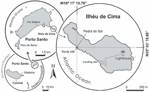
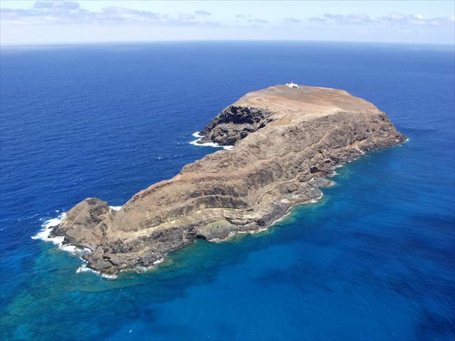
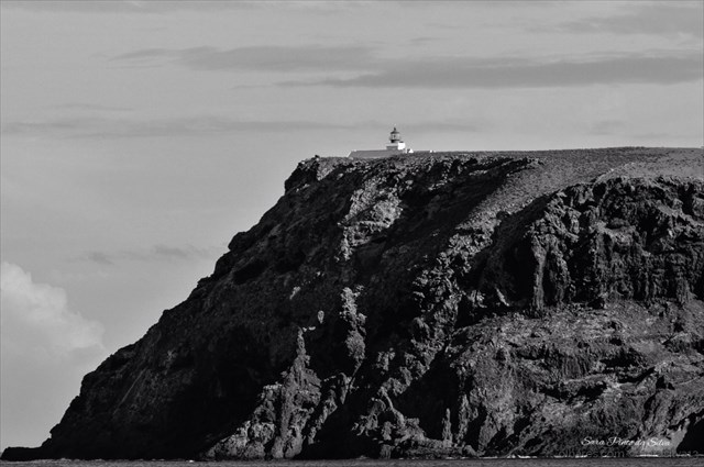
O Ilhéu de Cima é um ilhéu português a menos de 380 metros a sudeste da ilha do Porto Santo, na Região Autónoma da Madeira. O ponto mais alto mede 111 metros. É um ilhéu rochoso, com uma área de 32 hectares, cobertos por arbustos e flora costeira da Macaronésia, razão pela qual se encontra protegido pelo PDM, pela Rede Natura 2000 e é, ainda, parte integrante do Parque Natural da Madeira.
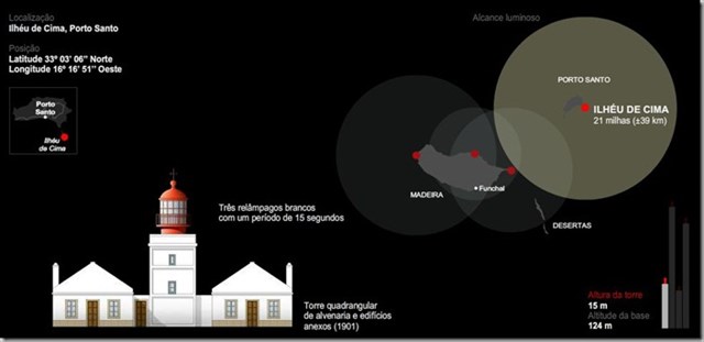
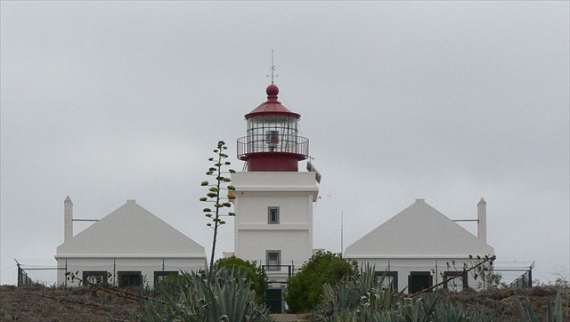
É também conhecido por Ilhéu do Farol, visto encontrar-se neste espaço geográfico o Farol do Ilhéu de Cima, farol esse muito importante devido a ser o primeiro farol para as embarcações provenientes da Europa.
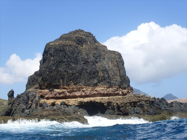
O ilhéu de Cima apresenta litologias representadas, essencialmente, por escoadas submarinas de natureza basáltica, níveis de calcários marinhos, fossilíferos, contemporâneos da fase de pré-emersão da ilha, durante o Miocénico Médio, assim como escoadas subaéreas de basalto. O topo do ilhéu encontra-se recoberto por depósitos eolianíticos do Quaternário.
Na ponta NW do ilhéu aflora, no “Cabeço das Laranjas”, uma elevada concentração de fósseis de idade Miocénica (15-14 Ma), contemporâneas da fase de pré-emersão da ilha.
Estes fósseis ocorrem entre dois complexos vulcânicos, um submarino basáltico (18,8 e 13,5 Ma) e outro subaéreo basáltico (14 e 10,2 Ma), facto que torna este afloramento um local de elevada relevância.
À semelhança dos outros ilhéus, esteve outrora ligado à ilha principal, e, por ação de fenómenos erosivos, a sua individualização ocorreu depois da última glaciação e deposição da Formação Eolianítica, durante o Holocénico, há menos de 10-12 mil anos.
CABEÇO DAS LARANLAS
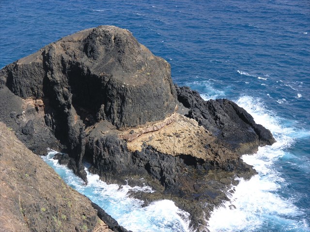
No lado oriental da ponta noroeste do Ilhéu de Cima, o “Cabeço das Laranjas” apresenta um espectacular afloramento de fósseis, denominados como “laranjas” pela sua enorme semelhança com este fruto. O conteúdo fóssil é maioritariamente composto por … numa camada com cerca de 6 metros de espessura com intercalações de cinzas vulcânicas, encontrando-se também vários outros fósseis presentes na zona.
PEDRA DO SOL
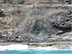
Os tubos de lava que podemos encontrar nas vertentes do Ilhéu de Cima são localmente designados como a “Pedra do Sol” pela estrutura raiada que apresenta.
FÓSSEIS
Os fósseis, (palavra derivado do termo latino fossilis que significa "desenterrado" ou "extraído da terra") são restos de seres vivos ou evidências de suas actividades biológicas preservados em diversos materiais. Essa preservação ocorre principalmente em rochas, mas pode ocorrer também em materiais, como: sedimentos, gelo, piche, resinas, solos e cavernas e os exemplos mais citados são ossos e caules fossilizados, conchas, ovos e pegadas.
A Paleontologia é a principal disciplina científica que utiliza fósseis como objecto de estudo , instaurada com a aceitação dos trabalhos de Georges Cuvier. Nessa área do conhecimento, os fósseis fornecem dados importantes quanto a evolução biológica, datação e reconstituição da história geológica da Terra.
A totalidade dos fósseis e sua colocação nas formações rochosas e camadas sedimentares é conhecido como registo fóssil, o qual contém inúmeros restos e vestígios fossilizados dos mais variados seres do passado geológico da Terra. Porém, apenas uma percentagem ínfima das espécies que já habitaram a Terra, preservou-se na forma de fósseis, já que a fossilização é considerada um fenómeno excepcional por contrapor-se aos processos naturais de decomposição e o intemperismo.
Logo, as partes esqueléticas biomineralizadas, mais duras e resistentes à decomposição e à erosão, tais como dentes, conchas, carapaças e ossos, é bem mais frequente e, por isso, a esmagadora maioria do registo fóssil é constituída por fósseis deste tipo de restos biológicos. Entretanto, restos orgânicos mais delicados e perecíveis também podem fossilizar. A preservação de matéria orgânica ou de restos esqueléticos delicados, uma vez que estes se decompõem e são destruídos rapidamente, requer condições de fossilização fora do comum que, por serem especiais, ocorrem na natureza mais raramente. Isso implica que fósseis de restos destes tipos não sejam frequentes. Em qualquer das circunstâncias, para que os restos de um qualquer ser vivo fossilizem, é fundamental que estes sejam rapidamente cobertos por um material que os preserve, geralmente sedimento.
Segundo algumas fontes, somente os restos ou vestígios de seres com mais de 11.000 anos seriam considerados fósseis. Este tempo, calculado pela última glaciação, é a duração estimada para a época geológica do Holoceno ou recente. Quando os vestígios ou restos possuem menos de 11.000 anos, seriam denominados de subfósseis. Entretanto, outros autores, consideram que um fóssil é todo e qualquer resto ou vestígio de seres vivos do passado preservado em contexto geológico, independentemente da sua idade. De acordo com estes paleontólogos, fixar uma qualquer data para se poder considerar se algo é ou não um fóssil é arbitrário. Por outro lado, sendo o Holocénico (menos de 11.700 anos) parte do registo geológico, os restos orgânicos contidos em materiais holocénicos deverão ser considerados fósseis. Ou seja, o que determina o fóssil é a ocorrência conjunta de um resto identificável com origem biológica num contexto geológico, independentemente do seu tipo e da sua idade.

Tipos de fósseis
Os fósseis são classificados em dois tipos: restos (ou somatofósseis) e vestígios (ou icnofósseis).
- Resto:tipo de fóssil que ocorre quando alguma parte do ser vivo é preservada. São consideradas evidências directas dos seres vivos. Por exemplo, fósseis de dentes, de carapaças, de folhas, de conchas, de troncos, etc.
- Vestígio:tipos de fóssil que ocorre apenas com evidências indiretas dos seres vivos, isto é, resultam de suas actividades biológicas. Por exemplo, estromatólitos, fósseis de pegadas, de marcas de mordidas, de ovos (da casca dos ovos), de excrementos (os coprólitos), secreções urinárias (urólitos), de gastrólitos, de túneis, de galerias de habitação, etc
A lista a seguir cita alguns exemplos de processos de fossilização:
criopreservação(mamutes preservados em gelo);
dessecação (dinossauros mumificados);
inclusão em âmbar(insectos em resina);
conservação de parte dura (ossos e conchas);
permineralização(lenhos e ossos);
incrustação (ossos e conchas em cavernas);
recristalização (conchas);
incarbonização ou destilação (restos vegetais);
substituição (por silicificação, piritização, limonitização ou carbonatização);
moldagem (vestígios).
ATENÇÃO
VISITA AO ILHÉU DE CIMA
Código do geossítio: PSt09
Denominação: Ilhéu de Cima - Cabeço das Laranjas
Categoria temática: Paleontologia
A visita ao ilhéu de Cima necessita de uma autorização prévia do Instituto de Florestas e Conservação da Natureza da Madeira (https://ifcn.madeira.gov.pt/).
Poderão contactar o IFCN através do email: ifcn@madeira.gov.pt.
A visita ao local de interesse geológico é da inteira responsabilidade do utilizador.
O utilizador deve tomar as devidas precauções quando visita o local, tendo em atenção as condições do terreno, condições climatéricas e outros perigos, para que não se criem situações que coloquem a sua integridade e a de outros em risco.
O utilizador deve respeitar a propriedade privada. O acesso a zonas privadas requer autorização prévia dos proprietários.
O utilizador deve respeitar o património natural mantendo-o intacto. O impacto das suas ações deve ser mínimo.
PARA REALIZAR E REGISTAR ESTA EARTHCACHE:
PERGUNTAS:
Para “encontrar/registar” esta cache deverá: provar que esteve no local, respondendo às seguintes questões, enviando um email/mensagem de Geocaching, com as respostas, em português ou em inglês, para o nosso perfil.
Só depois, de enviar as respostas, e conforme as “guidelines” para as Earthcaches, deverá efectuar o seu registo!
Serão removidos todos os registos que não obedeçam a estes requisitos.
1. Imagina que és um “paleontólogo” e responde às seguintes questões:
a) Os fósseis classificam-se em dois tipos. Quais são?
b) Quantos processos de fossilização existem? Quais são?
c) De que época provém os fósseis visíveis (em terra seca…), no Cabeço das Laranjas?
2. Observando o GZ, ponta NW do ilhéu “Cabeço das Laranjas”, responde às seguintes questões:
a) Identifica os fósseis (nome por que são conhecidos), que aparecem em maior número (“tipo laranjas”).
b) Estes fósseis foram produzidos por?
c) Mede e regista (com uma fita métrica) o tamanho médio (diâmetro médio) destes fósseis “tipo laranjas”.
d) Identifica, pelo menos, outros três “tipos de fósseis” presentes no local.
e) Identifica o processo de fossilização dos fósseis aí observáveis.
f) Os fósseis presentes são somatofósseisou icnofósseis?
g) Perto dos fósseis “tipo laranjas” existem três pedras “cúbicas” com cerca de um metro de aresta! Qual é a sua cor?
3. A partir da tua observação do fenómeno “Pedra do Sol”, responde às seguintes questões:
a) Explica, por palavras tuas, o processo geológico que levou à formação deste fenómeno geológico.
b) Estima a sua altura aproximada.
c) Identifica o tipo de fracturação existente na zona (por exemplo, atrás e à esquerda, da “Pedra do Sol”).
d) A cerca de cem metros da “Pedra do Sol”, no azimute 124º, existem umas rochas com disjunção esferoidal! Identifica o tipo de material presente nestas rochas.
4.
TAREFA OBRIGATÓRIA:Deverá tirar uma foto sua, onde você apareça (ou com um papel/placa onde conste o seu nickname e a data da visita) e que comprove a sua presença no GZ desta EC - NÃO METAM SPOILERS. Esta foto deverá ser colocada no seu registo ou enviada por email ou sistema de mensagens de Geocaching, para o owner!



THE “CABEÇO DAS LARANJAS”
and “PEDRA DO SOL”
[Ilhéu de Cima – Porto Santo – Madeira]
![]()
EARTHCACHE
[PALEONTOLOGY]
![]()
ENGLISH

The “ILHÉU DE CIMA”
(Porto Santo – Madeira island)
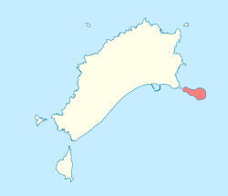
“Ilhéu de Cima” is a Portuguese islander less than 380 meters southeast of the island of Porto Santo, in the Autonomous Region of Madeira. The highest point is 111 meters. It is a rocky islet, with an area of 32 hectares, covered by shrubs and coastal flora of the Macaronesia, which is why it is protected by the PDM, the Natura 2000 Network and is also an integral part of the Natural Park of Madeira.
It is also known as “Ilhéu do Farol” (lighthouse), since the lighthouse of Ilhéu de Cima is located in this geographical area, a lighthouse that is very important because it is the first lighthouse for boats coming from Europe.
The islet of Cima presents lithologies represented, essentially, by submarine flows of basaltic nature, levels of limestone’s marine, fossiliferous, contemporaneous of the pre-emersion phase of the island, during the Middle Miocénnic, as well as subaerais of basalt. The top of the islet is covered by Quaternary eolianite deposits.
At the NW tip of the island, a high concentration of Miocene-age fossils (15-14 Ma) emerges at the "Cabeço das Laranjas", contemporaneous with the island's pre-emersion phase.
These fossils occur between two volcanic complexes, one basaltic submarine (18.8 and 13.5 Ma) and another basaltic subarea (14 and 10.2 Ma), which makes this outcrop a place of great relevance.
Like the other islets, it was once connected to the main island, and by erosive phenomena its individualization occurred after the last glaciation and deposition of the Eolianite Formation during the Holocene less than 10-12 thousand years ago.
“CABEÇO DAS LARANLAS”
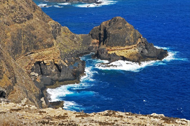
On the eastern side of the northwestern tip of “Ilhéu de Cima”, the "Cabeço das Laranjas" presents a spectacular outcropping of fossils, known as "oranges" for their great resemblance to this fruit. The fossil content is mostly composed of ... in a layer of about 6 meters thick with intercalations of volcanic ash, being also several other fossils present in the zone.
“PEDRA DO SOL”
![]()
The lava tubes that we can find in the slopes of the “Ilhéu de Cima” are locally designated as the "Stone of the Sun" by the raiated structure that it presents.
FOSSILS
Fossil, (word derived from the Latin fossils term meaning "dug up" or "extracted from the earth") are remains of living things or evidence of their biological activities preserved in various materials. This conservation occurs mainly in rock, but can also occur in materials, such as sediment, ice, tar, pitches, and soil caves and examples are the most frequently used bone and fossilized stems, shells, eggs and footprints.
Paleontology is the leading scientific discipline that uses fossils as object of study, established with the acceptance of Georges Cuvier jobs. In this area of knowledge, the fossils provide important data on biological evolution, dating and reconstruction of the geological history of the Earth.
The totality of fossils and their placement on the rocky formations and sedimentary layers is known as the fossil record, which contains numerous remains and fossilized remains of various beings of the Earth's geological past. However, only a tiny percentage of the species that once roamed the Earth preserved as fossils, since fossilization is considered an exceptional phenomenon for counteract the natural processes of decay and weathering. Therefore, the skeletal parts biomineralizadas, stiffer and resistant to decomposition and erosion, such as teeth, shells, bones and shells, is much more frequent and therefore the vast majority of fossil record is constituted by such fossil remains biological. However, more delicate and perishable organic debris can also fossilize. Preservation of organic material or delicate skeletal remains, since they decompose rapidly and are destroyed, requires conditions that fossilized unusual because they are special, more rarely occur in nature. This implies that fossil remains of these types are not frequent. In any event, that the remains of any living being fossilize it is vital that they are quickly covered by a material that preserves generally sediment.
According to some sources, only the remains or traces of beings with more than 11,000 years would be considered fossils. This time, calculated by the last ice age, is the estimated duration of the geological epoch of the Holocene or recent. When traces or residues are less than 11,000 years, would be called subfósseis. However, other authors consider that a fossil is any remains or traces of living things of the past preserved in geological context, regardless of their age. According to these paleontologists, fix any date for a finding whether or not something is a fossil is arbitrary. On the other hand, since the Holocene (least 11,700 years) of the geological record, contained in the organic waste Holocene fossil materials should be considered. That is, what determines the fossil is the joint occurrence of an identifiable rest of biological origin in a geological environment, regardless of its type, and its age.

Types of fossils
The fossils are classified into two types: debris (or somatofósseis) and traces (or trace fossils).
- Rest: type of fossil that occurs when some part of the living being is preserved. Direct evidence of living beings are considered. For example, fossil from teeth, shells, leaves, shells, trunks, etc.
- Trace: type of fossil that occurs only indirect evidence of living beings, i.e. the result of their biological activities. For example, stromatolites, fossil footprints, bite marks, eggs (egg shell), dung (coprolites), urinary tract secretions (uroliths) of gastroliths, tunnels, galleries of housing, etc.
The following list cites some examples of fossilization processes:
Cryopreservation (mammoth preserved on ice); desiccation (mummified dinosaurs);
inclusion in amber (insects in resin);
conservation hard part (bones and shells);
permineralization (logs and bones);
fouling (bones and shells in caves);
recrystallization (shells);
incarbonização or distillation (crop residues);
replacement (for silicification, pyritization, limonitização or carbonation);
molding (traces).
ATTENTION
VISIT TO THE “ILHÉU DE CIMA”
Geossítio code: PSt09
Name: “Ilhéu de Cima - Cabeço das Laranjas”
Topic category: Paleontology
The visit to the “Ilhéu de Cima” requires prior authorization from the Institute of Forests and Nature Conservation of Madeira (https://ifcn.madeira.gov.pt/).
You can contact the IFCN with the email: ifcn@madeira.gov.pt .
The visit to the site of geological interest is the sole responsibility of the user.
The user must take precautions when visiting the site, taking into account the conditions of the terrain, weather conditions and other hazards, so that they do not create situations that put their integrity and that of others at risk.
The user must respect private property. Access to private areas requires prior authorization from owners.
The user must respect the natural heritage keeping it intact. The impact of your actions should be minimal.
![]()
TO PERFORM AND LOG THIS EarthCache:
QUESTIONS:

To "find / register" this cache must: prove that visited the site and answer the following questions by sending an email / message Geocaching, with answers (in Portuguese or in English, only) to our profile.
Only later, sending the answers, and as the "guidelines" for EarthCaches should make your registration! They will be removed from all records that do not meet these requirements.
1. Imagine that you are a "paleontologist" and answer the following questions:
a) Fossils are classified into two types. Which are they?
b) How many fossilization processes are there? Which are they?
c) From what time do visible fossils come (on dry land ...), in Cabeço das Oranges?
2. Observing, GZ, NW tip of the "Cabeço das Laranjas" islet answers the following questions:
a) Identifies the fossils (name by which they are known), which appear in
greater numbers ("oranges type").
b) These fossils were produced by?
c) Estimate, by observation and measurement (with a tape measure) the average
size (mean diameter) of these "orange-type" fossils.
d) Identify at least three other "types of fossils" present on the site.
e) Identifies the process of fossilization of fossils observable there.
f) Are the fossils present somatofossils or icnofossils?
g) Near the "orange-type" fossils there are three "cubic" stones with about a meter of edge! What is your color?
3. From your observation of the "Stone of the Sun" phenomenon, answer the following questions:
a) Explain, in your words, the geological process that led to the formation of
this geological phenomenon.
b) Estimate your approximate height.
c) Identify the type of disjunction that exists in the zone (for example, behind and to the left, of the "Stone of the Sun").
d) About 100 meters from the "Pedra do Sol", on the 124th azimuth, there are rocks with spheroidal disjunction! Identifies the type of material present in these rocks.

4. TASK (not optional): You must take a picture of yourself, where do you show up, (or with a paper / plaque with your geocaching nickname and the date of the visit) and that proves your presence in the GZ of this EC - no spoilers please. This photo must be placed in your log or sent by email or Geocaching messaging system, to the owner!
