La Roche Percée
Cette curiosité géologique a donné son nom au village voisin de Pierre Perthuis.
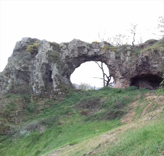
Témoin de la transgression triasique, la pierre percée est une formidable illustration des phénomènes de silicification ayant affecté la région de Vézelay. Son arche naturelle est due au revêtement silicifié, plus dur, plus résistant à l'altération que le granite fracturé dans lequel le perthuis s'est ouvert.
La silicification de la couverture inférieure est due à des circulations chaudes provenant du socle ayant remonté grâce à la fracturation dans les assises triasiques, hettangiennes ou sinémuriennes.
Une datation d'un feldspath de néogenèse a donné pour cette silicification un âge de 185 millions d'années environ.
On distingue 4 niveaux :
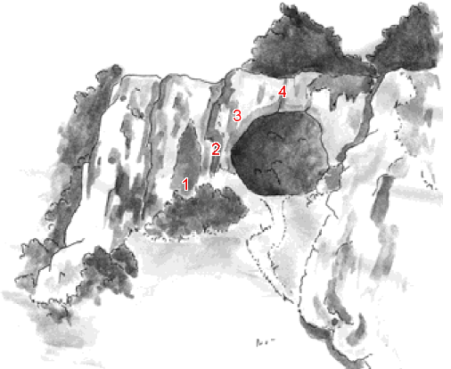
1 - A la base, affleur un granite frais appelé granite à deux micas ou leucogranite. On peut voir ce granite dans d'autres lieux du Morvan, notamment aux Roches du Chien, près de Saint-Brisson.
2 - Le deuxième niveau visible contient un leucogranite ayant subi une altération météorique (pluie, vent, gel, chaleur) actuelle ou quaternaire.
3 - Le troisième niveau est constitué d'une arène granitique qui date d'avant le Trias. Cette arène est silicifiée et la biotite la composant est transformée en chlorite au contact des veines de silice.
4 - Le sommet comprend le matériel silicifié proprement dit. Epais d'environ 2 mètres, il correspond sans doute à une ancienne dolomie représentant un faciès atypique de la fin de la transgression triasique.Toute la masse étant silicifiée et minéralisée, on ne peut plus reconnaître de filon distinct.
Rappel concernant les « Earthcaches »: Il n'y a pas de conteneur à rechercher ni de logbook à renseigner. Il suffit de se rendre sur les lieux, d'obsrever et de répondre aux questions posées.
Loguez cette cache "Found it" et envoyez-moi vos propositions de réponses soit via mon profil, soit via la messagerie geocaching.com (Message Center).
Une photo de vous sur ce site sera la bienvenue !
Questions :
1/ Qu'est ce que la silification ?
2/ De quand date celle de la Roche Percée ?
3/ Que pouvez vous lire sur le panneau aux coordonnées de la cache ?
4/ Touchez la roche du 2ème niveau du schéma. Que pouvez-vous dire de son aspect sous votre main?
5/ Observez la roche du niveau 4 du schéma. Quel aspect a t elle ? Pourquoi est-ce différent du niveau 2 ?
6/ Une photo de vous serait sympa...
English version
This geological curiosity gave its name to the neighboring village of Pierre Perthuis.

Witnessing the triassic transgression, the pierced stone is a wonderful illustration of the silicification phenomena that have affected the Vézelay region. Its natural arch is due to the silicified coating, harder, more resistant to alteration than the fractured granite in which the perthuis has opened.
The silicification of the lower cover is due to hot circulations coming from the base which have risen due to fracturing in the triassic, hettangian or sinemurian beds.
A date of a feldspar of neogenesis gave for this silicification an age of 185 million years approximately.


There are 4 levels:

1 - At the base, there is a fresh granite called granite at two micas or leucogranite. This granite can be seen in other places in the Morvan, notably at Roches du Chien, near Saint-Brisson.
2 - The second visible level contains a leucogranite which has undergone a meteoric alteration (rain, wind, frost, heat) or quaternary.
3 - The third level consists of a granite arena that dates from before the Triassic. This arena is silicified and the biotite component is transformed into chlorite in contact with the silica veins.
4 - The top includes the silicified material itself. It is about 2 meters thick and probably corresponds to an ancient dolomite representing an atypical facies of the end of the triassic transgression. All the mass being silicified and mineralized, it is no longer possible to recognize a distinct vein.


Reminder concerning the "Earthcaches": There is no container to be searched nor a logbook to be filled in. Simply go to the scene, observe and answer the questions asked.
Log in this "Found it" cache and send me your proposals for answers either via my profile or via messaging geocaching.com (Message Center).
A photo of you on this site will be welcome!

Questions :
1 / What is silification?
2 / When was the Roche Percee?
3 / What can you read on the panel with the coordinates of the cache?
4 / Touch the rock of the 2nd level of the diagram. What can you say about his appearance under your hand?
5 / Observe the rock of level 4 of the diagram. What was it like? Why is it different from Level 2?
6 / A picture of you would be nice ...
Sources : Patrimoine du Morvan