La Earthcache / The Earthcache
Une petite île à l'une des extrémités du continent eurasiatique, l'île d'Ouessant (Enez Eussa), dresse ses falaises à une vingtaine de kilomètres de la côte occidentale du pays de Léon: elle marque l'ultime avancée, dans l'Atlantique, du socle armoricain émergé.
Elle est la terre la plus occidentale de la France métropolitaine et l'un des promontoires ruiniformes de l'immense continent eurasiatique.
► Contexte géologique général
L'existence même de cette île, surgissant d'une centaine de mètres à l'entrée de la Manche, semble en relation avec le rejeu de failles transversales.
Ces mouvements tectoniques puissants sont à l'origine de plusieurs structures faillées amenant en contact anormal différents types de roches, principalement de nature granitique (granite à deux micas de Lokeltas, granite porphyroïde rose,...), surtout dans la partie septentrionale, avec une dépression médiane creusée dans des roches métamorphiques (micaschistes...), mais également des formations intrusives originales comme la trondhjémite ou de la pegmatite.
Cette petite série de EarthCaches va nous permettre de faire un rapide aperçu de cette diversité géologique de l'île.
Ce premier opus est l'occasion de découvrir une forme de roche intrusive originale, la trondhjémite, et les stigmates des mouvements tectoniques que cette roche a pu subir depuis sa mise en place.

► La trondhjémite, roche sodique intrusive
Ces roches constituent l'un des ensembles les plus originaux de l'île d'Ouessant.
Il s'agit de roches hololeucocrates (roches magmatiques très riches en minéraux clairs), caractérisées par une composition chimico-minéralogique singulière (rapport soude/potasse élevé).
Ces formations sodiques, quelquefois appelées « plagiogranites », sont intrusives dans les micaschistes de la dépression médiane de l'île.
Elles se sont mis en place il y a 456 millions d'années à l'état de magma, à plusieurs kilomètres sous terre au sein de formations métamorphiques. C'est le processus d'érosion qui a ensuite permis leur affleurement
Au niveau du port du Stiff, il s'agit d'une forme à faciès grenu. Elle forme un stock d'au moins 1 km de long, orienté approximativement WSW /ENE, sur environ 200 m de large au maximum.
À l'état frais, c'est une roche blanche, grenue, caractérisée en quasi-exclusivité par deux minéraux :
- Des plagioclases automorphes (famille des feldspaths), de couleur blanche assez terne.
- Du quartz à extinction roulante, de couleur gris translucide.

Elle renferme des plages d'un minéral particulier, le mispickel, généralement sous une forme altérée à l'air libre et formant alors de vastes taches rouille.
Cette roche peut par ailleurs être parcourue de filon de quartz de largeur centimétrique.
Ces inclusions permettent d'être le témoin des importants mouvements tectoniques que cette formation à subit au cours des âges géologiques, principalement des failles.

► Faille et rejet de faille
On appelle faille une cassure, une rupture de la continuité de terrains primitivement situés au même niveau et qui s’accompagne d'un déplacement relatif des compartiments qu'elle détermine.
Le rejet de faille correspond à la mesure du décalage qui s’est produit entre les deux compartiments séparés. Ce décalage peut comprend une composante verticale et/ou horizontale.
Il existe différents types de rejets, mais sur les roches magmatiques intrusives non litées comme la trondhjémite, c'est surtout les inclusions de filons de quartz qui vont permettre de mesurer ce rejet, en permettant de mesurer les discontinuités au sein d'un même filon.

A small island at one end of the Eurasian continent, the island of Ouessant (Enez Eussa), draws its cliffs about twenty kilometers from the western coast of the country of Leon: it marks the ultimate The Atlantic, the Armorican basement emerged.
It is the most western land of metropolitan France and one of the ruiniform promontories of the immense Eurasian continent.
► Local Geological Context
The very existence of this island, emerging from a hundred meters at the entrance of the Channel, seems in relation to the replay of transverse faults.
These powerful tectonic movements are at the origin of several faulty structures bringing into contact abnormal different types of rocks, mainly of granite nature (granite with two micas of Lokeltas, pink porphyroïde granite, ...), especially in the northern part, with A median depression excavated in metamorphic rocks (micaschistes ...), but also original intrusive formations such as trondhjemite or pegmatite.
This small series of EarthCaches will allow us to give a quick overview of this geological diversity of the island.
This first opus is the opportunity to discover an original form of intrusive rock, the trondhjemite, and the stigmata of the tectonic movements that this rock has been able to undergo since its installation.
► Trondhjemite, intrusive sodic rock
These rocks constitute one of the most original sets of the island of Ouessant.
These rocks are hololeucocrates (magmatic rocks very rich in light minerals), characterized by a singular chemico-mineralogical composition (sod / high potash ratio). These sodic formations, sometimes called "plagiogranites", are intrusive in the micaschists of the median depression of the island.
They were established 456 million years ago in the state of magma, several kilometers underground within metamorphic formations. It was the erosion process that allowed their outcrop.
At the level of the port of Stiff, it is a form with facies grenu. It forms a stock at least 1 km long, oriented approximately WSW / ENE, about 200 m wide at the most.
In the fresh state, it is a white, gray rock, characterized in almost exclusive by two minerals:
- Automorphic plagioclases (family of feldspars), of fairly dull white color.
- Quartz rolling extinction, translucent gray color.
It contains beaches of a particular mineral, the mispickel, generally in an altered form in the open air and then forming vast rust spots.
This rock can also be traversed by quartz vein of centimeter width.
These inclusions make it possible to be the witness of the important tectonic movements that this formation undergoes during the geological ages, mainly of the faults.
► Fault and fault rejection
A fault is a rupture, a rupture of the continuity of land originally situated at the same level, and which is accompanied by a relative displacement of the compartments which it determines.
The fault rejection corresponds to the measurement of the offset that occurred between the two separate compartments. This offset may include a vertical and / or horizontal component.
There are different types of discharges, but on untransformed intrusive magmatic rocks such as trondhjemite, it is mainly the inclusions of quartz veins that will allow to measure this rejection, allowing to measure the discontinuities within the same vein .
► Sources bibliographiques / Bibliographical sources
Les Questions / The Questions
La lecture attentive du descriptif de la cache, ainsi qu'une observation des éléments de terrain et un peu de déduction sont normalement suffisants pour répondre aux questions de cette EarthCache.
A careful reading of the description of the cache, as well as observation of terrain features and some deduction is usually sufficient to answer questions of this EarthCache.
Questions pour valider :"Trondhjémite et tectonique au Stiff"
Questions to validate: "Trondhjemite and tectonics in Stiff "
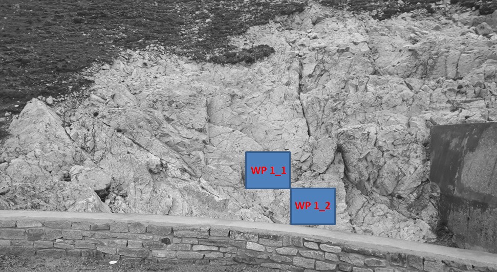
Vous voici devant une falaise, qui correspond au début de la jetée menant au bateau pour le continent (photo WP1_large). Nous allons observer différents endroits de cet affleurement.
Here you are in front of a cliff, which corresponds to the beginning of the jetty leading to the boat for the continent (photo WP1_large). We will observe different places of this outcrop.
La photo ci-dessous vous montre la photo W1_1, montrant un filon de quartz ayant subit un décrochement horizontal par une faille (photo WP 1).
The photo below shows the photo W1_1, showing a vein of quartz having undergone a horizontal displacement by a fault (photo WP 1).
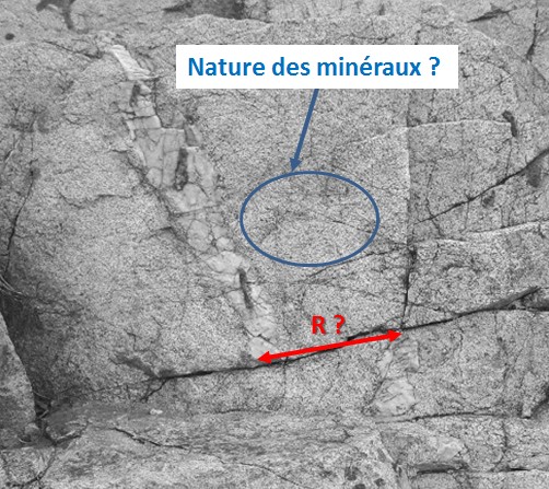
- Question 1 : Mesurez le rejet R de cette faille
- Question 1 : Measure the rejection R of this fault
- Question 2 : Observer de près la roche encaissante autour de ce filon de quartz (cercle bleu). Décrivez et identifier les minéraux qui la composent.
- Question 2 : Observe closely the surrounding rock around this quartz vein (blue circle). Describe and identify the minerals that compose it.
La photo ci-dessous vous montre la photo W1_2.
The photo below shows the photo W1_2.
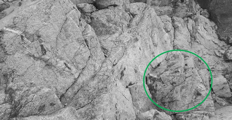
- Question 3 : Quelle coloration particulière prend des pans de la roche dans le cercle vert ? Quel en est le minéral à l'origine ?
- Question 3 : What particular coloring takes sides of the rock in the green circle? What is the mineral originally?
Vous pouvez vous loguer sans attendre notre confirmation,
mais vous devez nous envoyer les réponses en même temps soit par mail via notre profil (
fafahakkai), soit via la messagerie geocaching.com (Message Center).
S'il y a des problèmes avec vos réponses nous vous en ferons part.
Les logs enregistrés sans réponses seront supprimés.Une photo de vous ou de votre GPS avec le port en arrière plan serait la bienvenue, mais n'est pas obligatoire.
You can log this cache without waiting for our confirmation, but you must send us the answers at the same time, by e-mail via our profile (fafahakkai) or by the system of Message Center of geocaching.com.
If there is a problem with your answers we will notify you. The logs recorded without answers will be deleted.
A photo of you or your GPS with the harbor in the background would be welcome but is not mandatory.
Rappel concernant les « Earthcaches »: Il n'y a pas de conteneur à rechercher ni de logbook à renseigner. Il suffit de se rendre sur les lieux, de répondre aux questions ci-dessus et de nous renvoyer les réponses.
Reminder concerning "Earthcaches": there is neither a container to look for nor a logbook to sign. One need only go to the location, answer to the differents questions and send us the answers.