
L’histoire "récente" de la Combe de Savoie
La Combe de Savoie est la partie de la vallée de l’Isère située entre Albertville et la limite Savoie/Isère au sud de Montmélian. Elle est délimitée au Nord/Nord-Ouest par le massif calcaire des Bauges et sur son autre versant par les massifs cristallins de Belledonne et de la Lauzière.
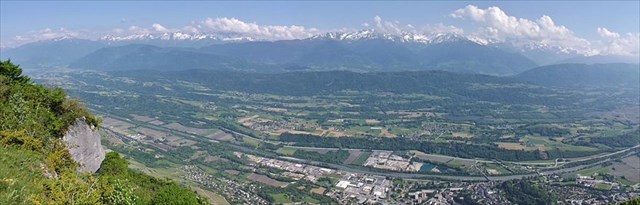
Il y a 30 000 ans, l’emplacement de cette earth-cache était sous par un immense glacier qui allait jusqu’à Lyon et dépassait l’attitude du col du Frêne. C’est l’action mécanique de ce glacier qui, en frottant le fond et les cotés de la vallée, a créé le profil en U de la combe de Savoie.
Il y a 18 000 ans, le glacier a fondu et en se retirant, a laissé un grand lac. Ce lac va progressivement se combler avec l’apport des alluvions charriées par l’Isère et ses affluents.
Pour pouvoir valider cette Earth-cache, vous devez vous rendre aux coordonnées indiquées où vous trouverez un panneau informatif qui vous permettra de répondre à la plupart des questions ci-dessous. Vos connaissances personnelles ou une petite recherche internet vous permettra de compléter le questionnaire.
Envoyez-moi vos réponses via mon profil ou la messagerie géocaching. Vous pourrez vous loguer en found-it sans attendre mon retour, mais je vous contacterai si vos réponses sont fausses ou incomplètes.
1 - Sur quel type de roche est bâti le château de Miolans ?
2 - Qu’est-ce qu’une rivière en tresse ?
3 - Quel est l’origine du lac de Carouge ?
4 - Il y a une erreur dans les légendes des images concernant l'histoire récente de la combe de Savoie en 4 images (sur le panneau explicatif). Quelle est cette erreur et sur quelle image apparaît-elle ?
5 - Comment appelle-t-on la vallée de l’Isère en amont de la Combe de Savoie ? Et comment appelle-t-on la vallée de l’Isère en aval de la Combe de Savoie ?
6 – Une petite photo est la bienvenue, mais n’est pas obligatoire.

"Recent" history of the Combe de Savoie
The Combe de Savoie is part of the Isère valley between Albertville and the Savoie/Isère border south of Montmélian. It ends on north/noth-west on the limestone Bauges Massif, and on the other side of the valley on the crystalline Belledonne and Lauzière Massifs.
30 000 years ago, this earth-cache was under a large glacier ranging as far as Lyon, reaching higher than the Col du Frêne. The physical action of this glacier modeled the U profile of the Combe de Savoie by rubbing on the bottom and sides of the valley.
18 000 years ago, the glacier melted and left a large lake behind. This lake progressively filled up with alluvial deposits carried by the Isère and its tributaries.
To check this earth-cache, you must reach the given coordinates and find there an information sign, which will help you answer most of the questions below. Your own knowledge or a little bit of research on the internet will help you complete the rest.
Send your answers via my profile or the geocaching messaging system. You can log yourself as "found it" without my confirmation, but I will contact you if the answer are wrong or incomplete.
1 - On what type of rock is the castle of Miolans built ?
2 - What is a braided river ?
3 - How was the Carouge lake formed ?
4 - There is a mistake on the information sign relatively to the explanation pictures. Can you find which picture is concerned and what the error is ?
5 - A little picture is welcome, but not required.