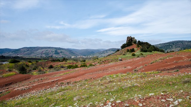

Situation géographique
Le neck se trouve à l'extrémité ouest du lac du Salagou.
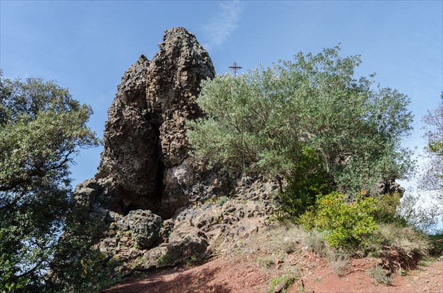
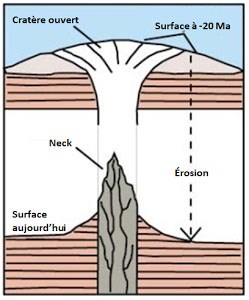
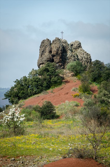
Description des necks
Un neck ou nek, est un relief volcanique résiduel en forme de pointe de grande dimension. Il correspond à une ancienne cheminée volcanique qui s'est solidifiée (par remplissage ou comblement vertical de matériel intrusif ou bréchique) à la fin d'une éruption et qui a été ensuite dégagée par l'érosion. Cette structure de lave solidifiée résiste mieux à l'érosion que les matériaux d'éjection qui l'entourent. Une fois le cône érodé, il reste une aiguille qui est la relique d'un cône disparu.
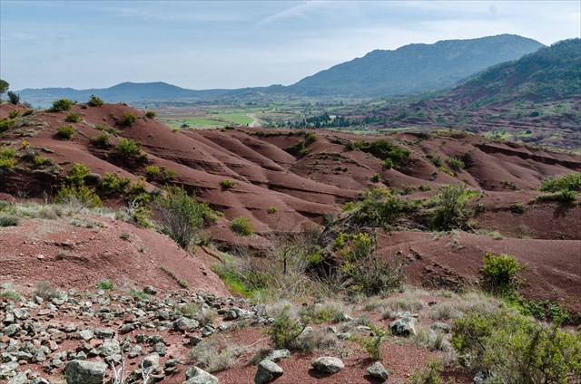
Les ruffes
Le bassin du Salagou est caractérisé par sa couleur rouge due à la présence d'oxydes de fer. L'origine de cette roche appelée "ruffe" (de rufus : rouge), remonte à l'époque permienne (fin de l'ère primaire, entre 280 et 225 millions d'années). Elle consiste en une épaisse couche de sédiments argileux ou gréseux qui se sont déposés par séquences régulières, correspondant à des phases d'assèchement ou d'envahissement lagunaires.
Elles en ont conservé des craquelures de dessiccation.
Inversion des pôles
Les pôles géographiques et magnétiques
Vous connaissez les pôles nord et sud points extrêmes de notre planète par lesquels passe l'axe de rotation de la terre et vers lesquels convergent tous les fuseaux horaires du monde. Ce sont les pôles géographiques.
Ceux-ci correspondent à peu près aux pôles magnétiques (à quelques centaines de km près et surtout de façon opposée). Le pôle nord magnétique se situe à proximité du pôle sud géographique et vice-versa. Ces pôles sont dus à un champ magnétique interne à la planète et les lignes de ce champ sortent par un point appelé pôle nord et se dirigent vers un point à l'opposé de la Terre appelé pôle sud.
Le pôle nord géographique et le pôle sud magnétique sont séparés de quelques centaines de km. En effet si le pôle nord géographique est un point qui ne bouge pas, le pôle sud magnétique se déplace lentement aux alentours du pôle nord géographique et se situe actuellement au nord du Canada. Quand vous utilisez votre boussole, elle vous indique donc le nord du Canada soit une direction presque au nord géographique (mais pas tout à fait et il y a une différence d'environ 4°).
Origine et rôle des pôles magnétiques
Comme dit plus haut, les pôles sont dus à un champ magnétique interne à la planète. Le cœur de notre planète est un noyau de fer liquide et très chaud en rotation (donc animé d'un mouvement).
Les mécanismes sont mal compris mais partons du principe de physique qu'un champ magnétique crée un courant électrique sur un métal en mouvement et vice-versa et supposons qu'au départ nous ayons dans ce noyau des atomes de fer orientés préférentiellement dans une direction donnée. Ces atomes vont alors créer comme dans un barreau de fer magnétique un champ magnétique qui aura une direction privilégiée même s’il est de faible intensité. Ce champ crée sur le métal (noyau de fer!) en rotation des lignes de courants électriques. Ces courants créent alors à leur tour un champ magnétique sur notre boule de métal qui vient s'ajouter au petit champ initial.
Au final un équilibre se crée avec un champ magnétique bien orienté et bien réel. Ce champ possédant un pôle sud vers notre pôle nord actuellement.
Ce champ constitue autour de la Terre un maillage de lignes de champ (les ceintures de Van Halen) qui piègent (magnétiquement donc) toutes les particules électriques se promenant dans les environs. Ces particules principalement d'origine solaire bombarderaient notre planète lors des fameuses éruptions solaires et ne laisseraient que bien peu de chances à la vie de se développer. Fort heureusement, elles sont piégées et sont canalisées vers les pôles nord ou sud (selon leur charge électrique) où elles brûlent dans la très haute atmosphère en éclairant le ciel de mille couleurs: les aurores boréales (au nord) et les aurores australes (au sud).
L'inversion des pôles dans l'histoire
Lors des éruptions volcaniques, certains atomes (le fer notamment) des roches en fusion (température comprise entre 700 et 1200°C) cristallisent avec des atomes d'oxygène en molécules de magnétite Fe2O3. Tant que la température est élevée, les cristaux de magnétite sont insensibles à l'aimantation ambiante due au champ magnétique terrestre. Mais dès que la température passe sous les 580°C (température dite de Curie), ces cristaux s'orientent dans le sens du champ magnétique (ou plutôt les spins, moment magnétiques internes à la molécule). La roche volcanique va donc garder une trace pour toujours (sauf si elle à nouveau chauffée à plus de 580°C) de l'orientation du champ magnétique terrestre au moment de son refroidissement.
On retrouve donc des roches volcaniques nous indiquant le nord géographique (donc le sud magnétique) jusque -700000 ans. Mais avant cette date, les roches pointent vers le sud. Le sud magnétique était donc au pôle sud ! Puis vers -820000 ans de nouveau vers le nord et ainsi de suite. On a très vite compris que le pôle sud magnétique ne se contentait pas de bouger lentement aux alentours du pôle nord, il migre carrément au pôle sud géographique de temps en temps !
Encore plus surprenant, une même coulée de lave (coulée sur quelques semaines donc) a dévoilé un rapide changement d'orientation qui montre que cette inversion peut ne prendre que quelques jours ou semaines. Cela signifie qu'après 700000 ans passée avec un pôle sud magnétique au nord, il peut se retrouver l'été prochain au sud!
Pour valider la cache
-- Conformément aux guidelines de Groundspeak --
Envoyez-moi vos propositions de réponses soit via mon profil, soit via la messagerie geocaching (Message Center), PUIS loguez cette cache 'Found it'. Je vous contacterai en cas de problème.
Vu le nombre de logs que je reçois sans message, tout log posté sans avoir envoyé les réponses aux questions sera supprimé sans avertissement.
1. De quelle matière est constitué le neck ?
2. De quelle période datent les ruffes du Salagou ?
3. Observez votre boussole à côté du neck, qu'est-ce qui est pointé par le nord ? Puis allez dans la petite cavité. Vers quelle partie de la cavité pointe le nord ?
4. [Optionnel] Une photo de vous et/ou de votre GPS sur le site (à inclure dans le log.)
|
Une boussole est indispensable pour pouvoir répondre aux questions
Pour pouvoir valider cette earth-cache, vous allez avoir besoin d'une boussole.
Le mieux est de venir avec une vraie boussole, mais une application boussole sur votre smartphone peut très bien faire l'affaire (il faut que cette dernière se base sur le capteur boussole du téléphone et non sur le GPS.)
|

Geographical situation
The neck is located at the western end of the Lake of Salagou.
Description of the necks
A neck or nek, is a residual volcanic relief shaped tip of great dimension. It corresponds to an ancient volcanic chimney which has solidified (By vertical filling or filling of intrusive or brecciated material) at the end of an eruption and then cleared by erosion. This solidified lava structure is more resistant to erosion than the surrounding ejection materials. Once the cone has been eroded, there remains a needle that is the relic of a disappeared cone.
The ruffes
The Salagou basin is characterized by its red color due to the presence of iron oxides. The origin of this rock called "ruffe" (from rufus: red), dates back to the Permian period (End of the primary era, between 280 and 225 million years). It consists of a thick layer of clayey or sandy sediments deposited in regular sequences, corresponding to lagoon drying or invading phases.
They have preserved desiccation cracks.
Reverse poles
The geographical and magnetic poles
You know the north and south poles extreme points of our planet through which passes the axis of rotation of the earth and towards which converge all the time zones of the world. These are the geographical poles.
These correspond approximately to the magnetic poles (to a few hundreds of kilometers and especially opposite). The magnetic north pole is located close to the geographic south pole and vice versa. These poles are due to a magnetic field internal to the planet and the lines of this field leave by a point called North pole and go towards a point opposite the Earth called South pole.
The geographic north pole and the magnetic south pole are separated by a few hundred km. Indeed, if the geographic north pole is a point that does not move, the magnetic south pole moves slowly around the geographic North Pole and is currently located in northern Canada. When you use your compass, it tells you so the Canada Northern is a direction almost at the geographical North (but not quite and there is a difference of about 4°).
Origin and role of magnetic poles
As said above, the poles are due to a magnetic field inside the planet. The heart of our planet is a very hot and rotating iron core (therefore animated by a movement).
The mechanisms are misunderstood but let us start from the principle of physics that a magnetic field creates an electric current on a metal in motion and vice versa and suppose that at the beginning we have in this nucleus iron atoms preferentially oriented in a given direction . These atoms will then create as in a magnetic iron bar a magnetic field which will have a privileged direction even if it is of low intensity. This field creates on the metal (iron core!) in rotation, lines of electric currents. These currents create a magnetic field on our metal ball which is added to the small initial field.
Finally, a balance is created with a well-oriented and real magnetic field. This field has a south pole towards our North Pole currently.
This field constitutes around the Earth a mesh of lines of field (the belts of Van Halen) which trap (magnetically therefore) all the electrical particles circulating in the surroundings. These particles, mainly of solar origin, would bomb our planet during the famous solar eruptions and leave very little chance of life to develop. Fortunately, they are trapped and are channeled towards the north or south poles (according to their electrical charge) where they burn in the upper atmosphere by illuminating the sky with a thousand colors: the aurora borealis (north) and aurora australis (south).
The reversal of the poles in history
During volcanic eruptions, certain atoms (especially iron) of molten rocks (temperature between 700 and 1200 ° C) crystallize with oxygen atoms into molecules of magnetite Fe2O3. As long as the temperature is high, the magnetite crystals are insensitive to the ambient magnetization due to the earth's magnetic field. But as soon as the temperature passes below 580°C (Curie temperature), these crystals are oriented in the direction of the magnetic field (or rather the spins, magnetic moments internal to the molecule). The volcanic rock will therefore keep a trace forever (unless it is heated to more than 580°C) of the orientation of the earth's magnetic field at the time of its cooling.
We thus find volcanic rocks indicating the geographic north (thus the magnetic south) up to -700000 years ago. But before that date, the rocks point to the south. The magnetic south was therefore at the South Pole! Then towards -820000 years back to the north and so on. It was quickly realized that the magnetic south pole was not content to move slowly around the north pole, it migrates squarely to the geographical south pole from time to time!
Still more surprising, the same lava flow (casting over a few weeks) revealed a rapid change of orientation that shows that this inversion may take only a few days or weeks. This means that after 700,000 years with a magnetic south pole to the north, it can end up next summer to the south!
To validate the cache
-- In accordance with Groundspeak guidelines --
Send me your suggested answers via my profile either via messaging geocaching (Message Center), THEN log this cache 'Found it'. I will contact you in case of problems.
Given the number of logs I receive without a message, any log posted without having sent the answers to the questions will be deleted without warning.
1. The neck is made of what material?
2. What period did the Salagou ruffes?
3. Observe your compass next to the neck, what is pointed by the north? Then go into the small cavity. What part of the cavity is pointed by the north?
4. [Optional] A picture of you and/or your GPS (to be included to the log)
|
A compass is essential to be able to answer questions
In order to validate this earth-cache, you will need a compass.
The best is to come up with a true compass, but a compass on your smartphone app can very well do the trick (It must be based on the compass sensor of the phone and not on the GPS.)
|