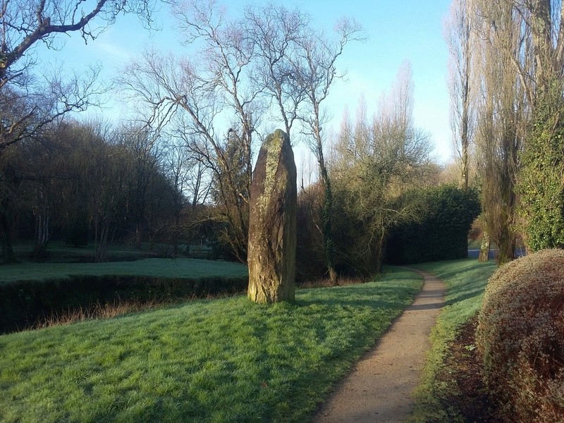
La Bretagne est une terre de mégalithes et Landivisiau n'échappe à la règle.
Avec cette cache vous aurez l'occasion d'approcher l'un ces représentants d'une autre époque au sein de Landivisiau.
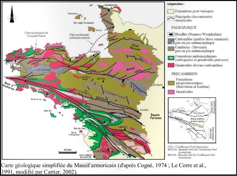
Le massif Armoricain, où se situe Landivisiau, est le vestige d'une ancienne montagne datant de l'ère primaire, formant un socle de roches cristallines et de sédiments de l'ère primaire. Cette montagne a été fortement érodée et a formé une pénéplaine. Au cours de l'ère tertiaire cette plateforme a subi des déformations qui ont soulevée le nord du Cotentin, le Bocage Normand, l'ouest de la Bretagne et la Vendée. Par contre le centre s'est enfoncé, ce qui a permis l'invasion par la mer (région de Rennes) et basse vallée de la Loire (mer des faluns). Au cours de ces déformations les cours d'eau se sont enfoncés. L'érosion qui a repris a mis en saillie les roches les plus dures. A certains endroits on a un relief appalachien.
Le granite représente 40 % du massif armoricain. Il marque de son empreinte la région. Des millions d’années d’érosion ont sculpté les côtes et les sols de la péninsule ; apportant joie aux bâtisseurs et tristesse aux agriculteurs qui, inlassablement, doivent contourner l’obstacle pour labourer leurs champs. Dans certains endroits, comme à Saint-Nicodème, dans les Côtes-d’Armor, le granite donne même l’impression de « pousser » au milieu des prairies !
Les premières traces d’exploitation remontent à 4 200 ans avant notre ère. Le Cairn de l’île de Gavrinis, dans le golfe du Morbihan, montre que l’on savait dès l’époque mégalithique graver le granite. Dans ce dolmen à chambre unique, recouvert par un empilement de pierres de 50 mètres de diamètre, les dalles des parois ont été soigneusement percutées pour dessiner un entrelacs de motifs d’une finesse émouvante.
Pour valider cette earthcache, il vous faudra vous rendre auprès du menhir et trouver les réponses aux questions suivantes.
- 1/ Quelle est la hauteur du Menhir de Landivisiau ?
- 2/ Quelle est sa circonférence sur le point le plus large ?
- 3/ En prenant en compte la densité du granite, évaluez le poids de la partie visible du menhir.
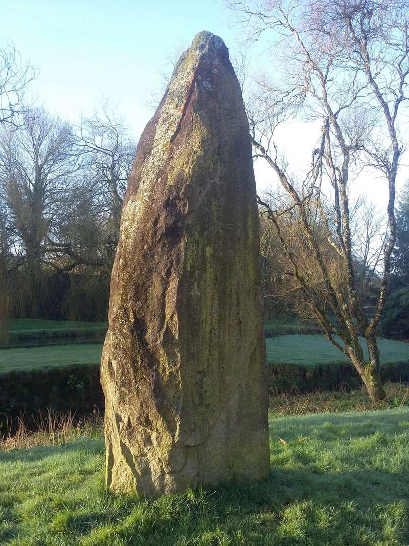
- 4/ En vous basant sur la photo ci-dessous, indiquez la composition du granite.

Des photos de vous devant le spot seraient fortement appréciées.
"Loguez cette cache "Found it" et envoyez-nous vos propositions de réponses soit via notre profil, soit via la messagerie geocaching.com (Message Center), et nous vous contacterons en cas de problème."

Brittany is a land of megaliths and Landivisiau is no exception.
This cache will give you the opportunity to approach one of these representatives of another era within Landivisiau.
Landivisiau belongs to the Armorique range which is what remains of an ancient mountain dating back to the Palaeozoic age, forming a base of crystalline rocks and sediments of the Palaeozoic age. This mountain has been intensely eroded and came to form a peneplain. During the Tertiary era, this platform underwent deformations which rasied the north of Cotentin. the wooded countryside of Normandy, Western Brittany and Vendée. On the contrary, the center sunk which allowed the invasion from the sea (Rennes region) and the lower Loire valley (Faluns sea). During these deformations the waterways sunk too. When the erosion resumed it left the hardest rocks jutting out . In some places you can see an Appalachian relief.
Granite represents 40% of the Armorique range.The region is tinted with its traces. Millions of years of erosion have sculpted the shores and the grounds of the peninsula, bringing joy to the builders and sadness to the peasants who have to bypass the obstacle relentlessly to plough their fields. In certain places, for example in Saint Nicodème (in Côtes d'Armor), granite almost gives you the impression that it is "growing" in the meadows!
The first traces of farming date back to 4200 years before Christ. The Cairn of the Gavrinis Island, in the Gulf of Morbihan, shows that as early as the era of the megaliths, people knew how to carve granite. In this dolmen with a unique chamber, covered in a piling of stones 50 meters in diameter, the slabs on the walls have been hit with great care to draw an interlacing of motifs with moving delicacy.
To validate this earthcache you will need to go next to the menhir and find the answers to the following questions:
- 1) What is the height of the Landivisiau menhir?
- 2) What is its circumference at the widest point?
- 3) Taking into account the density of granite, estimate the weight of the visible part of the menhir.
- 4) Basing your answer on the picture below, indicate the composition of granite.
Pictures of you in front of the spot would be highly appreciated.
"Log in this" Found it "cache and send us your responses either via our profile or via the geocaching.com message center, and we'll contact you if there is a problem."