L’étoile de la Traconne
Un peu d’histoire
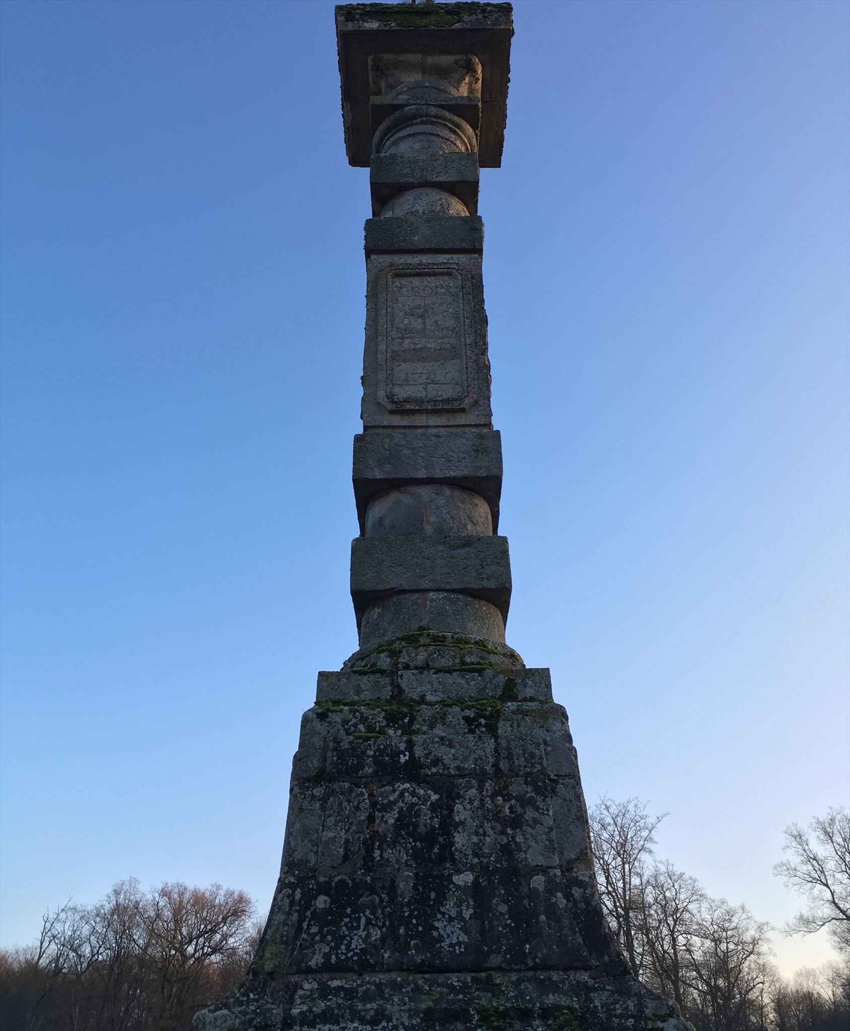
Le carrefour de l'étoile est situé au cœur de 4 500 hectares de forêt (La Traconne). Il est le point de départ de huit circuits de randonnée. Au centre se dresse une colonne de grès érigée en 1726 et à proximité est planté un faux (hêtre tordu et noueux). La pyramide était le point de rendez-vous d'Henry IV lorsqu'il venait chasser dans la forêt de la Traconne.
/!\ Accessible toute l'année mais attention aux jours de chasse /!\
La Traconne : 4.000 hectares d'une forêt située à la limite de la Marne, la Seine-et-Marne et l'Aube. Elle est parcourue de nombreux sentiers et de plusieurs routes forestières. Ces dernières convergent toutes à un point central du massif forestier, baptisé la clairière ou le carrefour de l'Étoile.
Il s'agit d'un vaste rond-point d'herbe situé au beau milieu de la forêt. En son centre, un monument, une colonne de grès gris surmontée d'une croix de fer qui a été érigée au XVIIIe siècle. C'est près de cette clairière de l'Etoile qu'Henri IV aurait offert à Gabrielle d'Estrées un pavillon de chasse.
À côté de la colonne se trouve une belle maison forestière datant du milieu du XIXe siècle. A coté, le spécimen unique d'un arbre très rare. C'est ici que se trouve le seul hêtre tortillard, un faux, qui déploie des branches aux formes tourmentées.
C'est au carrefour de l'Étoile que débute le sentier botanique de la forêt de la Traconne long de 1,8 km qui permet de découvrir les différentes essences d'arbres de la forêt. Huit autres circuits de randonnées et de très nombreux sentiers prennent aussi leur départ du carrefour de l'Étoile.
Géologie : le Grès
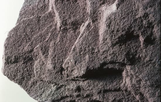 Le grès est une roche détritique, issue de l’agrégation et de la cimentation (ou diagenèse) de grains de sable. Il peut s'agir d'une roche cohérente et dure. Ces grains sont souvent composés de silice (et parfois même de grains de feldspath et de micas noirs), mais ils peuvent avoir d’autres compositions. On parle alors plutôt d'arénite, en particulier si les grains sont carbonatés.
La cimentation des grains se fait par précipitation et cristallisation des sels dissous dans l’eau interstitielle. On appelle ce processus la « grésification ».
Les grains, et le ciment entre ces grains peuvent avoir une composition différente selon l’origine et l’histoire de ce grès. Les dépôts successifs de sable se retrouvent dans la stratification du grès. La roche prend des couleurs différentes en fonction de la présence d'oxyde de fer.
Loguez cette cache "Found it" et envoyez-moi vos propositions de réponses soit via mon profil, soit via la messagerie geocaching.com (Message Center), et je vous contacterai en cas de problème.
Question :
- De quel type de Grès s’agit-il ?
- Donnez-moi la hauteur de ce monument.
- Quelle est la texture du Grès ?
- Le grès est-il entièrement homogène, ou peut-on voir des orientations préférentielles, par endroits ? ou partout ?
Optionnel: Mettre une photo de vous et ou de votre GPS dans votre log.
The star of the Traconne
A little history
The crossroads of the star is located in the heart of 4,500 hectares of forest (La Traconne). It is the starting point of eight hiking trails. In the center stands a column of sandstone erected in 1726 and nearby is planted a false (beech twisted and knotty). The pyramid was the rendezvous point of Henry IV when he came to hunt in the forest of La Traconne.
/!\ Accessible all year round but watch out for hunting days /!\
La Traconne: 4,000 hectares of forest located on the edge of the Marne, the Seine-et-Marne and the Aube. It is traversed by many trails and several forest roads. The latter all converge at a central point of the forest massif, baptized the clearing or the crossroads of the Star.
It is a vast roundabout of grass located in the middle of the forest. In its center is a monument, a column of gray sandstone surmounted by an iron cross which was erected in the eighteenth century. It was near this clearing of the Etoile that Henri IV offered Gabrielle d'Estrées a hunting lodge.
Next to the column is a beautiful forest house dating back to the mid-19th century. Beside, the unique specimen of a very rare tree. It is here that the only tortilla beech tree, a false, is spreading branches with tormented forms.
It is at the crossroads of l'Étoile that begins the botanical trail of the forest of the Traconne 1.8 km long that allows to discover the different tree species of the forest. Eight other hiking trails and many trails also depart from the Étoile crossroads.
Geology: the Sandstone
Sandstone is a detrital rock, resulting from the aggregation and cementation (or diagenesis) of sand grains. It can be a coherent and hard rock. These grains are often composed of silica (and sometimes even grains of feldspar and black micas), but they may have other compositions. Arenite is therefore referred to, particularly if the grains are carbonated.
The grain is cemented by precipitation and crystallization of the dissolved salts in the interstitial water. This process is called "slipping".
The grains, and the cement between these grains may have a different composition according to the origin and the history of this sandstone. The successive deposits of sand are found in the stratification of sandstone. The rock takes on different colors depending on the presence of iron oxide.
To validate this Earthcache, you will have to answer some questions, for this go to my profile send me your answers.
Question:
- What type of sandstone is this?
- Give me the height of this monument.
- What is the texture of Sandstone?
- Is the sandstone completely homogeneous, or can we see preferential orientations in places? Or anywhere?
Optional: Put a picture of you and / or your GPS in your log.
Bon geocaching!