
Situation géographique
L'abîme de Rabanel est situé à l'est de la montagne de la Séranne, sur la commune de Brissac.
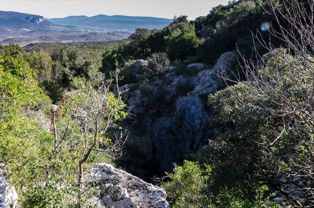
Vaste bouche portée sur la carte en rive droite d'une vaste combe. Un bon chemin d'accés à partir de Coupiac (que la Ford de R. de Joly emprunta en 1932...) y conduit.
Garez-vous au niveau du hameau de Coupiac près du panneau "Abîme de Rabanel". Empruntez le chemin à droite de la maison puis suivre un sentier bien marqué qui part sur la droite. Dans la montée, délaissez un départ de sentier sur la gauche. Arrivé sur zone, Repérez deux départs de sentier sur la gauche qui conduisent après 10 m à la bouche du gouffre située légèrement en contre-haut du sentier.
Environ 20 min de marche d'approche.
Histoire
Première exploration par EA Martel au cours de sa deuxième campagne (1889). Le 29 Juin, il reconnait l'orifice et sonde le puits.
Après un intermède le 30 Juin et le 1e Juillet (son anniversaire de trente ans) au cours duquel il réalise la première descente du canyon de l'Hérault en canot Osgood. Le 2 Juillet, il va voir "les cenotés" de Brissac et la Foux de la Buèges.
Le 3, il atteint le fond de Rabanel qu'il cote -212m...
En Mai 1932, soit 43 ans après, R de Joly y redescend et écrit à Martel le 23 Mai 1932 une lettre un peu vexante, réduisant la cotation du fond à -195m et relatant son combat de coqs avec le très indépendant Louis Balsan qu'il qualifie de "cassant et mal élevé"...
De Joly retrouve la bourse du berger Boyer qui était tombé dans l'aven, et le faible contenu de cette bourse fait peser sur lui les soupçons des habitants de Brissac.
En 1951, le GSG réalise sans succès des essais aux fumigènes pour déceler l'origine du courant d'air issu de la cheminée.
En 1975, trois groupes spéléos Lodévois découvrent la suite au niveau d'une coulée où Robert DE JOLY avait signé, et explorent les deux salles concrétionnées.
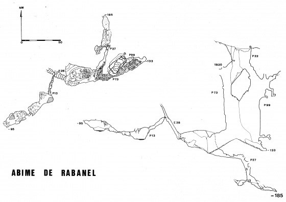
Description de l'abîme
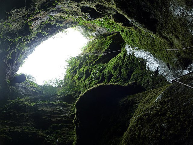
A -23m, il y a un palier d'où partent deux puits parallèles. Le grand puits Sud, vaste, mesure 89m, subvertical au début jusqu'à -56m, puis dans le vide sur 56m. Le puits du Nord ou du chapeau (92m) est plus étroit.
A -110m, on trouve un cône d'éboulis, une vaste salle, et une galerie en pente aboutissant à -149m devant un puits de 24m.
Il y a un fond d'argile (ruisseau temporaire) à -181m.
Cet aven fut longtemps le plus profond de France, avec une profondeur estimée à -212m (Martel) ou -195m (R. de Joly). En 1939, il occupait encore le 11e rang.
Le 1er avril 1951, le GSG (A. Bancal) en lève un plan précis et étudie sa spéléogenèse.
L'aven se trouve sur une zone de fractures. Un grand accident EW se voit sur la paroi Sud de la grande salle.
La galerie du ruisseau, au Nord, est dans une zone laminée à schistosité verticale.
Au bas de l'éboulis, coté Est, Bancal signale un galet bien roulé de granite à mica noir.
Une température basse (piège à air froid) est retrouvée à 7.5°C par de Joly (1932) et Bancal (1950).
Au fond, le SCAL (S. Azémard et N. Bonnin) signale un léger courant d'air le 22 juin 1985.
En 1975 le SC Lodève (à la suite de la lecture de la note de Bancal) escalade la cheminée de Joly et aboutit à une salle 20m x 30m couverte de gours, avec au bas un lac 10m x 5m.
Au plafond galerie de 30m. Aprés désobstruction d'une chatière, on trouve une nouvelle salle 20m x 30m.

Géologie
Un abîme est une formation géologique caractéristique des régions karstiques des causses et vallées de l'Aveyron et de la Lozère dans le Massif central.
Il est le plus souvent formé par l'effondrement de la voûte d'une cavité karstique (ou grotte) dû à la dissolution des couches calcaires par l'eau de pluie.
Un abîme est donc une cavité dont l'accès s'ouvre dans le sol et qui présente sur tout ou partie de son développement la forme d'un puits vertical ou sub-vertical, ce qui la rend difficilement accessible sans matériel spécifique.
Les dimensions de l'ouverture en surface de ces cavités béantes sont très variables : de quelques décimètres jusqu'à deux cents mètres, de même la profondeur peut être impressionnante.

Vidéos
Je n'ai personnellement pas eu l'occasion de visiter cet abîme, mais il y a des vidéos de groupes ayant eu cette chance :
Visite
Speleolining
Pour valider la cache
-- Conformément aux guidelines de Groundspeak --
Envoyez-moi vos propositions de réponses soit via mon profil, soit via la messagerie geocaching (Message Center), PUIS loguez cette cache 'Found it'. Je vous contacterai en cas de problème.
Vu le nombre de logs que je reçois sans message, tout log posté sans avoir envoyé les réponses aux questions sera supprimé sans avertissement.
1. Estimez la plus grande longueur de l'entrée de l'abîme ?
2. Donnez 2 caractéristiques géologiques de cet abîme ?
3. Citez au moins 4 autres abîmes (ou gouffres) qui se trouvent en France ?
4. [Optionnel] Une photo de vous et/ou de votre GPS sur le site (à inclure dans le log.)
|
Consignes élémentaires de sécurité
- Evitez de partir seul ou informez un proche de votre trajet.
- Ne vous aventurez pas en cas d'orage ou de pluie.
- Portez de bonnes chaussures.
- Restez bien derrière la barrière et surveillez les enfants !
- Il n'y a pas besoin de matériel spécifique pour faire cette cache.
|

Geographical situation
The abîme of Rabanel is located to the East of the mountain of the Séranne, in the commune of Brissac.
Wide mouth worn on the map on the right bank of a wide Valley. A good path from Coupiac (that the Ford of R. Joly borrowed in 1932...) led there.
Park at the hamlet of Coupiac near the sign "Abîme de Rabanel". Take the path to the right of the house and then follow a well marked trail that runs to the right. In the climb, leave a path on the left. Arrived on the spot, Locate two trail departures on the left which lead after 10 m to the mouth of the abîme located slightly up against the trail.
Approximately 20 min walk approach.
History
First exploration by EA Martel during its second campaign (1889). On June 29, he recognized the orifice and probed the well.
After an interlude on 30 June and 1 July (his thirtieth birthday) during which he made the first descent of the canyon of the Hérault in an Osgood canoe. On 2 July, he went to see the "cenotés" of Brissac and the Foux de la Buèges.
On the 3rd, it reaches the bottom of Rabanel that counts -212m ...
In May 1932, 43 years later, R de Joly returned and wrote to Martel on 23 May 1932 a somewhat vexing letter, reducing the bottom rating to -195m and recounting his cock fight with the very independent Louis Balsan that he Qualifies as "brittle" and "bad manners"...
De Joly found the scholarship of the shepherd Boyer, who had fallen into the aven, and the feeble content of this purse puts the suspicions of the inhabitants of Brissac upon him.
In 1951, the GSG carries out smoke tests without success to detect the origin of the air flow from the chimney.
In 1975, three Lodevois speleological groups discovered the continuation at the level of a flow where Robert DE JOLY had signed, and explored the two concretioned rooms.
Description of the abîme
At -23m, there is a landing from which two parallel wells leave. The large South well, vast, measures 89m, subvertical at the beginning until -56m, then in the vacuum on 56m. The northern well or the hat (92m) is narrower.
A -110 m, there is a cone of scree, a Hall and a gallery on a slope leading to -149m in front of a 24m well.
There is a bottom of clay (temporary stream) at -181m.
This aven was long the deepest in France, with a depth estimated at -212m (Martel) or -195m (R. de Joly). In 1939, he was still ranked 11th.
On April 1, 1951, the GSG (A. Bancal) raised a precise plan and studied its speleogenesis.
The aven is located on a fracture zone. A big accident EW sees on the wall South of the large room.
The creek gallery in the north is in a laminated zone with vertical schistosity.
At the bottom of the scree, on the east side, Bancal points to a well-rolled black granite.
A low temperature (cold air trap) is found at 7.5°C by de Joly (1932) and Bancal (1950).
Inside, the SCAL (S. Azemard and N. Bonnin) reports a slight air stream June 22, 1985.
In 1975 the SC Lodève (following the reading of the note of Bancal) climbs the chimney of Joly and culminates in a room 20m x 30m covered with gours, with at the bottom a lake 10m x 5m.
On the ceiling, following a gallery of 30m. After clearing a cat flap, we find a new room 20m x 30m.
Geology
An abîme is a geological formation characteristic of the karstic regions of the causses and valleys of Aveyron and Lozère in the Massif Central.
It is most often formed by the collapse of the vault of a karst cavity (or cave) due to the dissolution of the limestone layers by rainwater.
An abyss is so a cavity whose access opens in the ground and which present on all or part of its development in the form of a vertical or sub-vertical, well which makes it difficult to reach without special equipment.
The dimensions of the opening at the surface of these gaping cavities are very variable: from a few decimeters to two hundred meters, so the depth can be impressive.
Videos
I personally didn't have the opportunity to visit this abîme, but there are videos of groups having this chance:
Visiting
Speleolining
To validate the cache
-- In accordance with Groundspeak guidelines --
Send me your suggested answers via my profile either via messaging geocaching (Message Center), THEN log this cache 'Found it'. I will contact you in case of problems.
Given the number of logs I receive without a message, any log posted without having sent the answers to the questions will be deleted without warning.
1. Estimate the greater length of the entrance to the abîme?
2. Give 2 geological features of this abîme ?
3. Cite at least 4 other abîmes (or chasms) that are in France?
4. [Optional] A picture of you and/or your GPS (to be included to the log)
|
Basic safety instructions
- Avoid to go alone or notify your ride to someone.
- Do not venture during a storm or rain.
- Wear good shoes.
- Stay well behind the fence and watch the children!
- There is no need special equipment to do this cache.
|