Abandoned Hooes Road (FSf #2) Traditional Geocache
Abandoned Hooes Road (FSf #2)
-
Difficulty:
-

-
Terrain:
-

Size:  (other)
Please note Use of geocaching.com services is subject to the terms and conditions
in our disclaimer.
My Forgotten Springfield series will take you to forgotten little corners of Springfield, revealing forgotten little bits of history. The series currently also includes award-winning Ghost Lake, Cross County Expressway, and Crossroad Development.
 NoVAGO
Nominee for Best Traditional Cache
Nominee for Best Camouflage
2017
NoVAGO
Nominee for Best Traditional Cache
Nominee for Best Camouflage
2017
This cache is along an abandoned segment of Hooes Road in Springfield -- a road with a long history.
In 1791, Colonel John Hooe established a ferry that crossed the Occoquan River at the town of Occoquan. The ferry was the southern terminus of the road called Hooe's Ferry Road. Obviously, the apostrophe and "ferry" were eventually dropped from the name.
The pronunciation of the road has also changed. Old-time locals will tell you that the correct pronunciation is "hose" not "whose". (Note that this is similar to Roosevelt, which is also properly pronounced with a "rose".)
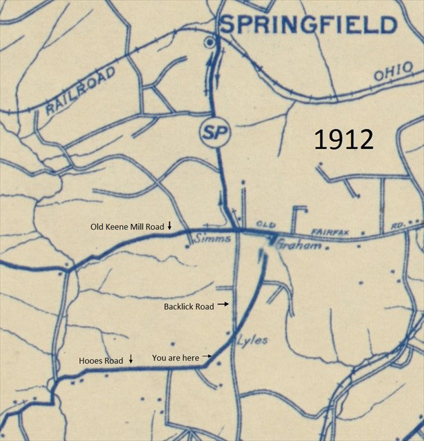
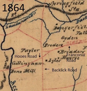
In recent decades, Hooes Road has been sidelined, segmented, and supplanted by larger roads. Ox Road has replaced the southern most segment, toward the town of Occoquan. The north-south segment between Ox Road and the Fairfax County Parkway is mostly intact. Then Hooes Road disappears, supplanted by the Fairfax County Parkway. A loop of Hooes Road runs north of the parkway, through the historic Sydenstricker community, before falling victim to the parkway again. It reappears south of the parkway, from Gambrill Road to about Rolling Road. Barker's Crossroads (at Hooes and Rolling) is now long gone. Hooes Road then reappears east of Rolling Road, south of the Franconia-Springfield Parkway, meandering through a beautiful wooded section and then paralleling the parkway. Parking for this cache is at the official end of today's Hooes Road.
Historically however, Hooes Road continued beyond this point, and you will walk a bit of it. As you can see, the road begins to bend to the northeast. Hooes Road once formed a Y-intersection with Backlick Road, somewhere near today's footbridge. In fact, Hooes Road crossed Backlick Road and continued northeast, potentially following the course of today's Loisdale Road and Loisdale Court, before terminating at today's Franconia Road, near the Hilton Hotel. This northeast trajectory and intersection can be seen in these maps from 1912 and 1864. Presumably the portion of Hooes Road east of Backlick disappeared with the construction of Shirley Highway (now I-95) in the 1940s.
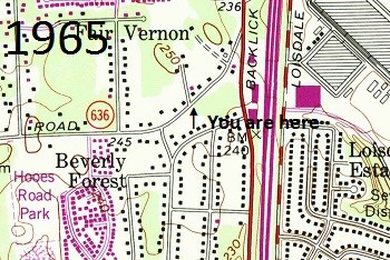
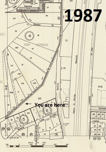
The segment you are walking along was abandoned in the early 1990s, with the completion of the Franconia-Springfield Parkway. Note the homes and properties on the north side of Hooes Road that were taken in the process:
You are looking for a micro hidden (largely) inside a larger natural container along the edge of the road. As intended, no bushwhacking is required (or any contact with vegetation). Your feet needn't leave the road. No spoiler photos please. Please treat with care. Bring your own pen.
Congratulations to dragonfly367 on being the FTF.
Additional Hints
(Decrypt)
Gur angheny pbagnvare vf nobhg gjb srrg.