[GN17] Le Ravin de Pihem EarthCache
-
Difficulty:
-

-
Terrain:
-

Size:  (other)
Please note Use of geocaching.com services is subject to the terms and conditions
in our disclaimer.
 FRANÇAIS
Un ravin est une petite vallée constituée d'une dépression allongée, profonde et généralement étroite, aux versants relativement raides (de l'ordre de 20 à 70 %).
Les ravins de Pihem et d’Hallines (aussi appelé Ravin du Noir Cornet) ont été creusés par des cours d'eau aujourd'hui disparus. Ce sont des vallées sèches.
On distingue deux types principaux de vallées sèches :
- Les vallée sèche par capture hydrographique : Le cours d'eau à l'origine du creusement a été détourné de son lit par un autre. La partie de l'ancien cours d'eau situé en aval de la capture devient une vallée sèche.
- Les vallée sèche par perte d’eau : C’est une vallée formée suite à la disparition de l'écoulement en raison de l'infiltration des eaux dans le sous-sol calcaire. L'eau infiltrée peut soit réapparait en aval, soit rejoindre directement la nappe phréatique.
, 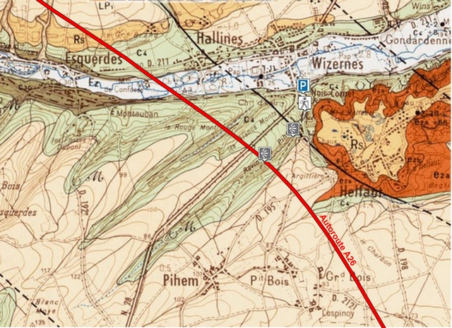
Carte géologique des environs de Pihem : LP1 : Limons pléistocènes, Rs : Formations résiduelles à silex, Fz : Alluvions modernes, e2a : Argile de Louvil et Tuffeau de Saint-Omer, e2b : Sables et Grès d'Ostricourt, C4 : Craie sénonienne, C3c : Craie du Turonien supérieur
Comme pour toutes les earthcaches, l’objectif n’est pas de découvrir une boîte.
Pour valider votre visite, il vous suffit de vous rendre aux différents points de référence indiqués. Cette petite promenade, ainsi que le descriptif ci-dessus vous permettront de valider cette earthcache en répondant aux questions suivantes :
1 - Citez le nom d'un autre ravin, voisin du Ravin de Pihem.
2 - Au point de référence R1 (Pont de l'Autoroute A26) : Les plaques de béton recouvrant les piliers du pont mesurant environ 3 m de hauteur, quelle est la profondeur approximative du ravin ? En vous appuyant sur la définition proposée, pensez vous que la vallée sèche de Pihem peut être appelée un ravin ?
3 - Au point de référence R2 (Erosion du versant) : Quel type de roche affleure au niveau du chemin descendant du versant (vous pouvez vous aider de la carte géologique ci-dessus) ? Déduisez en le type de vallée sèche présente au Ravin de Pihem.
Après avoir visité l'ensemble des points de référence, loguez cette earthcache "Found it" et envoyez-moi vos propositions de réponses soit via mon profil, soit via le Message Center. Je vous contacterai en cas de problème.
 ENGLISH
The ravines of Pihem and of Hallines (also called the Ravine of Noir Cornet) were dug by rivers that have now disappeared. They are dry valleys.
There are two main types of dry valleys:
- Dry valley by hydrographic capture: The stream at the origin of the dig was diverted from its bed by another. The part of the old stream downstream of the capture becomes a dry valley.
- Dry valley by loss of water: It is a valley formed due to the disappearance of the flow due to the infiltration of water into the chalk subsoil. The infiltrated water can either reappear downstream or directly reach the water table.
,
Geological map of Pihem : LP1: Pleistocene silt, Rs: Flint residual formations, Fz: Modern alluvium, e2a: Louvil clay and Saint Omer tuffeau, e2b: Ostricourt sand and sandstones, C4: Senonian chalk, C3c: Upper Turonian chalk
As with all Earthcaches, the goal is not to find a box.
To validate your visit, you simply go to different indicated reference points. This little walk, and the above description will help you to validate this earthcache by answering the following questions:
1 - Mention the name of another ravine, near the Ravine de Pihem.
2 - At the reference point R1 (Bridge of the A26 motorway): The concrete slabs covering the bridge pillars measuring approximately 3 m in height, what is the approximate depth of the ravine? Based on the proposed definition, do you think that the dry valley of Pihem can be called a ravine?
3 - At reference point R2 (Slope erosion): Which type of rock is flush with the descending path of the slope (you can use the geological map above)? Deduce to the type of dry valley present at Pihem Ravine.
After visiting all the reference points, you can log this earthcache as "Found it" and send me your answers via my profile or via the message center. I will contact you in case of problems.
Additional Hints
(No hints available.)