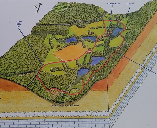
La Clairière de Bresolettes ressemble comme toutes les vallées de la région à la vallée typique du Perche
The Clearing of Bresolettes resembles like all the valleys of the area the typical valley of the Perche
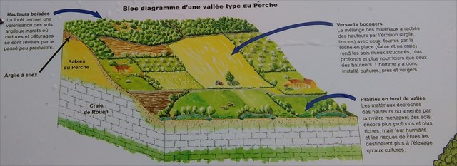
Les sols riches et profonds de ces vallées sont souvent engorgés en eau permanente et souvent réservé à l'élévage. Sur les versants, les sables de la couche géologique n'ont pas été nourris par les limons et les argiles des hauteur et donc les sols sont pauvres en substances nutritives qu'en eau. La productivité agricole y est donc médiocre et abandonnée au profit des landes et des boisements.
En lisant le panneau qui contient les réponses, 3 étapes ont permis à cette formation de ces collines et vallées.
Question 1: La géologie du Perche est le résultat de l'empilement successif de nombreuses couches de sédiments (calcaire, sable, grés, marnes..) et se sont déposés sur un vieux socle. Comment sont arrivés ses différents sédiments ?
Question 2: La couche de craie s'est ensuite retrouvée à l'air libre et s'est altérée sous l'action de facteurs climatiques. Durant l'ère tertiaire le vieux socle s'est fracturé avec l'apparition d'un massif. Quel est le nom de ce massif?
Question 3: Le travail continu de l'érosion a entaillé et décapé les roches sédimentaires les plus tendres donnant au Perche son relief actuel. A quoi ressemble le relief du Perche?
Question 4: Sur le panneau, il y'a un dicton?
Merci de loguer et de m'envoyer les 4 réponses par message ou par mail, en cas de mauvaise réponse je vous contacterai.
The rich and deep grounds of these valleys are often blocked out of permanent water and often booked with the breeding. On the slopes, sands of the geological layer were not nourished by the silts and clays height and thus the grounds are low in nutritive substances only out of water. The agricultural productivity is thus poor and abandoned there with the profit of the moors and the afforestations
By reading the panel which contains the answers, 3 stages allowed this formation of these hills and valleys.
Question 1: The geology of the Perche is the result of the successive stacking of many layers of sediments (limestone, sand, likings, marnes.) and settled on an old base. How did its various sediments arrive?
Question 2: The layer of chalk was then found with the free air and deteriorated under the action of climatic factors. During the tertiary era the old base was fractured with the appearance of a solid mass. Which is the name of this solid mass?
Question 3: The continuous work of erosion notched and pickled the sedimentary rocks most tender giving to the Pole its current relief. With what does resemble the relief of the Perche?
Question 4: On is the panel, it there a diction?
Thank you for loguer and to send to me the answers by message or e-mail, in the event of bad answer I will contact you