| I am a proud |
 |
If you have already completed either of my Earthcaches Danger Point Rocks or The Cataract you may already know how the Zambezi Gorge and Victoria Falls formed. However I will recap some of the relevant information for those that may not have.
About 200 million years ago tectonic activity caused a break up of the landmass that was Gondwanaland. This caused huge cracks or fissures to form in the earth's crust from which erupted huge volumes of molten basalt.
Stretching from the Botswana border to the Matetsi River which isn’t too far from here, an isolated area of this basalt remains exposed. It is over this which the present-day Zambezi flows and has cut its path forming these gorges. The Zambezi is Africas fourth longest river after the Nile. Congo and Niger. Its catchment area is roughly 1,320,000 square kilometres.
See Earthcache 'Great River' to learn more about the formation of the Zambezi River.
It is believed that the river will erode its next north-south break-through at the western side of the falls, either at the Devil's Cataract, which is already several meters lower than the majority of the Fall-line, or by exploiting the cleft behind Cataract Island, which although it has very little water flow during most of the year, at times of high flow carries a significant volume of water.
From GZ or the platform next to the cafe/bar look east up the river (towards the bridge), the bank and rock face to the left is the 7th site of the Victoria Falls. Where the river bends away to the left downstream is the 6th site of the falls and that means you are roughly standing where the equivalent of todays Devils Cataract was. This would have slowly cut away the rock to form the gorge you can now see.
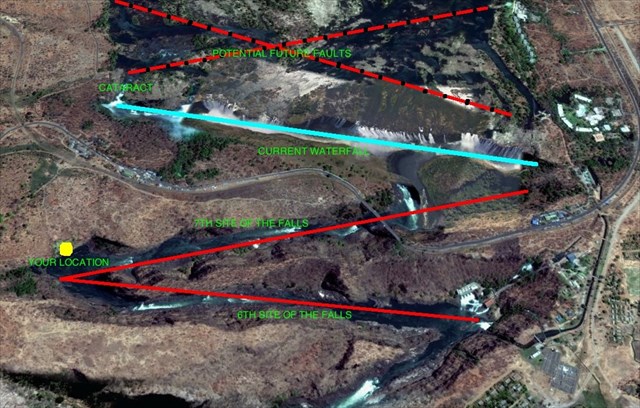
Birds eye view of gorges 6 and 7
In human terms this process is incredibly slow and in the hundred and fifty years since the Falls were discovered to the world there has been little appreciable change. In 1862, the explorer and artist Thomas Baines visited the region and drew his famous paintings and etchings of the Falls, and those of the Devil's Cataract have been suggested as evidence of visible erosion in this section since this time. However early photographs show very little evidence of change over the last 100 years.
The old wide river bed downstream of the Victoria Falls has, amongst its alluvial (river washed) deposits, revealed the occasional evidence of Stone Age man, in the from of tools, up to 18 kilometres downsteam of the current fall-line. This shows that Stone Age man must has witnessed the Falls at these earlier stages in its formation before the gorges eroded their way down and back through the river bed, perhaps between 250-500,000 years ago. Its has been calculated that it has taken nearly 100,000 years for the river to erode back from the Songwe River to the Third gorge (or sixth fall-line). Using this evidence as a basis to estimate the rate of upstream erosion has lead some to predict a rate of 7 metres every 100 years, or 7 cm each year.
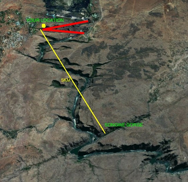
It has taken roughly 100 000 years to erode from the Songwe Gorge to where you stand today .
However the temptation to estimate rates of erosion is made complex by the variation in the rates of erosion at different stages in the erosion process (the north-south rate of erosion, when the river flow is concentrated into the narrow gorges, will be much faster than the north-south rate of erosion when the water falls over the wide bed of the river), along with many other factors such as geology, geography and climate.
This type of erosion is known as headward erosion and generally makes a river longer. Vertical erosion makes a river channel deeper and this gorge is a great example of this. This usually happens more in the upper stages of a river (the V of vertical erosion should help you remember the v-shaped valleys that are created in the upper stages. This has happened differently with the Zambezi where the lower part has created a gorge). Lateral erosion makes a river wider. This occurs mostly in the middle and lower stages of a river.
To claim a find please email your answers to me via the GC.com website (DO NOT POST YOUR ANSWERS IN YOUR LOG). There is no need to wait for confirmation before logging; if there is a problem with your answers I will get back to you.
1 Up to present times, how many sites of the falls has there been?
2 Although basalt is usually described as being grey to black in colour, as you can see on the gorge wall opposite GZ it rapidly weathers to brown or rust-red. What mineral do you think is in the rock causing this?
3 Again Looking at the wall surface of the gorge, what do you notice about the way the basalt erodes, does it appear to crumble or wear smoothly?
4 What is your elevation
5 Optional: post a picture of you, your group or device with the gorge in the background
FOR MORE INFORMATION ON EARTHCACHES PLEASE CLICK HERE