La Earhcache / The Earhcache
Les bords de la Rance dévoile tout au long de leurs falaises un riche passé géologique, témoin des bouleversements qui se sont produits au cours des âges.
La grève de Morlet, sur la commune de Langrolay-sur-Rance, est particulièrement riche en enseignements. Cette petite série, intitulée Géol'Morlet, part à la découverte de ses secrets géologiques.
Cette troisième étape va nous permettre de découvrir ce que les roches encaissantes, issues de l'orogenèse cadomienne, ont pu subir lors de l'orogenèse hercynienne.
► Contexte géologique local
Etudions ce que nous dit la carte du BRGM quand nous l’interrogeons pour connaître la nature de la roche constituant les falaises de Morlet.
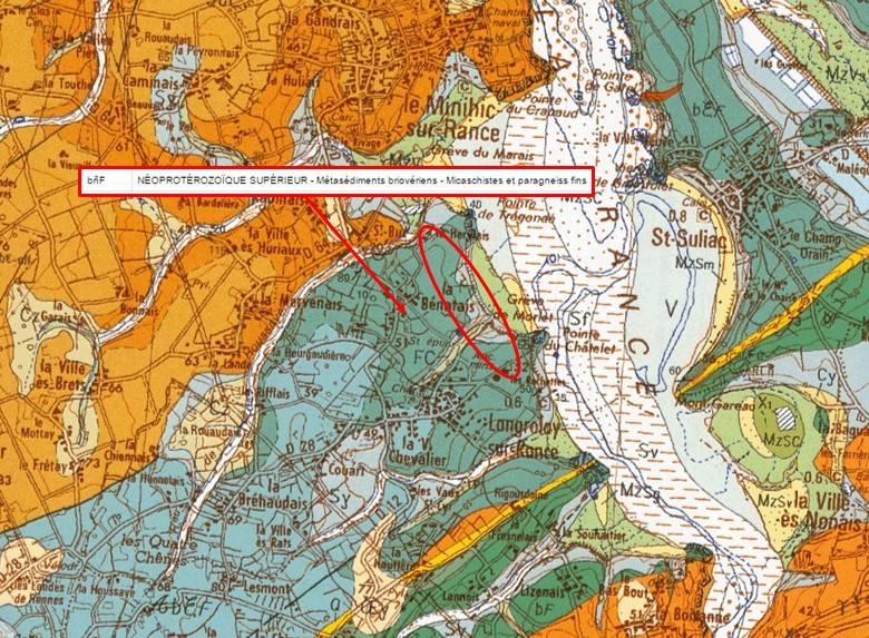
Couche "b?F" - Micaschistes et paragneiss fins : Cette formation de roches métamorphiques, succédant au schistes et grès nommée "bF", constitue une formation de lithologique voisine à ces derniers mais avec un degré métamorphique plus élevé. Ces micaschistes alternent à différentes échelles avec des niveaux paragneissiques (plus gréseux à l’origine).
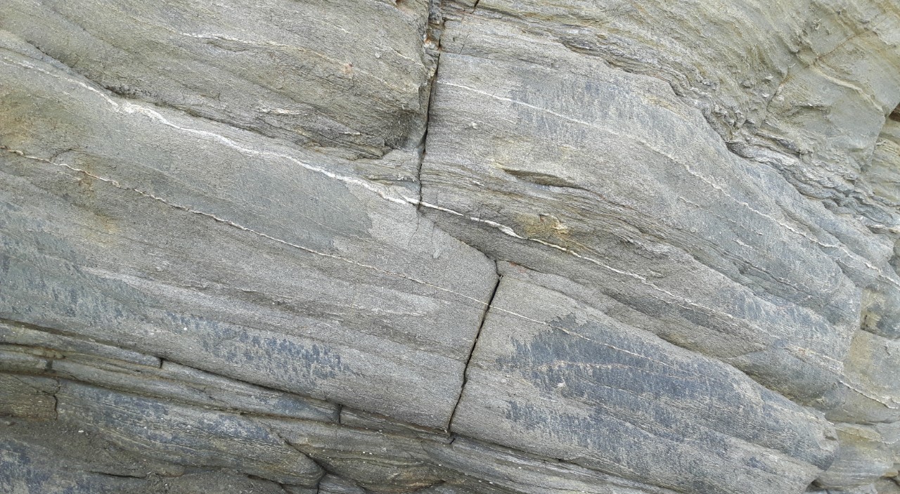
Les micaschistes comme les paragneiss fins sont des roches métamorphiques litées (c'est à dire qu'elles présentent une schistosité donnant des couches) qui se sont formées lors de la surrection de la chaîne cadomienne (orogenèse cadomienne).
Cette phase formation a eu lieu il y a 550 millions d'années.
- Les micaschistes sont des roches à quartz, plagioclase, biotite et chlorite. Elle se caractérise par une foliation et une schistosité très fines (car issus du métamorphisme d'une roche sédimentaire argileuse).
Cette roche est plutôt sombre, de couleur verdâtre due à la présence de chlorite.
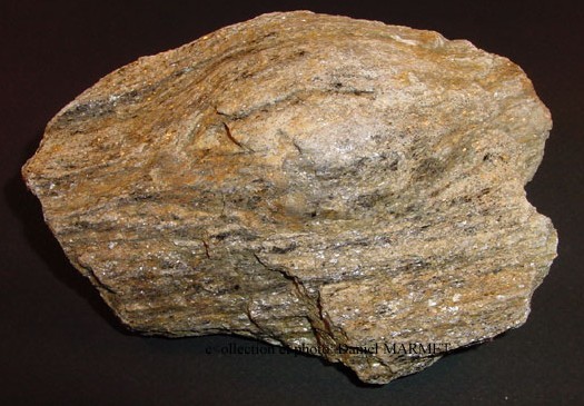
- Les paragneiss plagioclasiques contiennent du quartz, plagioclase et biotite. Ils présentent des minéraux plus grossiers, et ont également une schistosité très marquée. Leur coloration est plus claire, de teinte jaune-ocre (virant au rouge sous l'effet de la mise à l'air libre).
Mais une autre roche est présente au milieu de ces roches primitives. Comment est-elle arrivée là ?
► La dolérite, fruit de l'orogenèse hercynienne
Après l'orogenèse cadomienne, qui a eu lieu il y a 550 millions d'années, la zone correspondant au massif armoricain continue à se déplacer au gré de la tectonique des plaques.
Et vers 330 millions d'années (Dévonien), il se produit un rapprochement puis le chevauchement de trois masses continentales : le microcontinent de l'Armorica entre les deux supercontinents du Protogondwana et de la Laurussia (à ce moment l'Amérique du Nord et l'Eurasie formaient un seul continent). Ce rapprochement aboutit au supercontinent de la Pangée.
Il est responsable de la formation de la chaîne de montagnes appelée chaîne hercynienne (ou chaîne armoricaine, ou encore chaîne varisque), orogène sinueux de 3 000 km de long et 6 000 m d'altitude initialement.
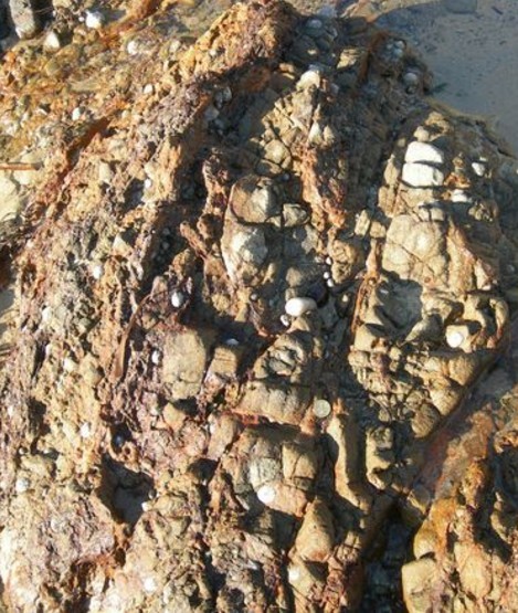
Ces mouvements tectoniques majeurs entraînent l'apparition de failles majoritairement orientées Nord/Sud dans les roches métamorphiques cadomiennes, dans lesquelles un magma de nature basaltique se met en place aux travers de filons offrant une roche de grain fin, sans litage et très dure appelée dolérite
De couleur initiale bleuâtre à verdâtre, cette roche quand elle est soumises à l'air libre, prend une teinte brunâtre à rougeâtre du fait de l’oxydation des minéraux ferromagnésiens.
► Principe de datation géologique
Il existe plusieurs type de datation relative des roches et événements géologiques.
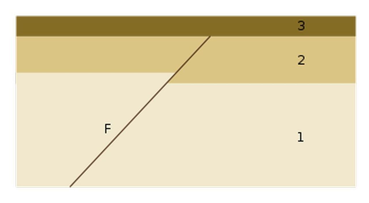
L'un d'entre eux est le principe de recoupement : Un événement (intrusion magmatique, faille, plissement, discordance, érosion) qui provoque un changement dans la géométrie des roches est postérieur à la dernière strate qu'il affecte et antérieur à la première strate non affectée.
Autrement dit, tout événement géologique qui en recoupe un autre lui est postérieur.
Dans l’exemple ci-dessous, la faille/filon F est postérieur aux strates 1 et 2, mais antérieure à la strate 3.
The banks of the Rance reveal all along their cliffs a rich geological past, witness of the upheavals that have occurred over the ages.
The shore of Morlet, in the town of Langrolay-sur-Rance, is particularly rich in teachings. This little series, entitled Géol'Morlet, sets out to discover its geological secrets.
This third stage will allow us to discover the pressures that the enclosing rock originating from the Cadomian orogeny could undergo during the Hercynian orogeny and the consequences on the rocks present on the cliff.
► Local Geological Context
Let us study what the map of the BRGM tells us when we interrogate it to know the nature of the rock constituting the cliffs of Morlet.
Layer "b? F" - Micaschistes and fine paragneiss: This formation of metamorphic rocks, succeeding the schist and sandstone called "bF", constitutes a lithological formation adjacent to the latter but with a higher metamorphic degree. These mica schists alternate at different scales with paragneissic levels (more sandy at the origin).
Micaschists, such as fine paragneisses, are metamorphic rocks (ie, they have a layered schistosity) formed during the uplift of the Cadomian chain (cadomian orogenesis).
This phase of implementation took place 550 million years ago.
- Micaschists: these are quartz rocks, plagioclase, biotite and chlorite. It is characterized by very fine foliation and schistosity (due to the metamorphism of a clayey sedimentary rock).
This rock is rather dark, of a greenish color due to the presence of chlorite.
- Plagioclastic paragneisses contain quartz, plagioclase and biotite.
They have coarser minerals, and also have a very marked schistosity. Their color is lighter, yellow-ocher tinged (Turning red under the effect of alteration).
But another rock is also present in the middle of these primitive rocks. How did she get there?
► The dolerite, the fruit of the Hercynian orogeny
After the cadomian orogeny, which took place 550 million years ago, the zone corresponding to the Armorican massif continues to move according to the tectonics of the plates.
And about 330 million years ago (which began in the Devonian and ended with the Permian), there is a rapprochement and then the overlap of three continental masses: the microcontinent of Armorica between the two supercontinents of Protogondwana and The Laurussia (at that time North America and Eurasia formed a single continent). This convergence. This rapprochement culminated in the supercontinent of the Pangea.
It is responsible for the formation of the mountain range known as the Hercynian chain (or chain armorican or chain varisque), winding orogenous 3 000 km long and 6 000 m altitude initially.
These major tectonic movements lead to the appearance of faults in Cadomian metamorphic rocks, mostly oriented North / South, in which a magma of basaltic nature is placed through veins offering a rock of fine grain, without bedding and very hard called Dolerite.
Initially bluish to greenish, this rock when exposed to the open air takes on a brownish to reddish color due to the oxidation of ferromagnesium minerals.
► Principle of geologic dating
There are several types of relative dating of rocks and geological events.
One of them is the principle of overlap: An event (intrusion magmatic fault, folding, unconformity, erosion) which causes a change in the geometry of the rocks is after the last affected layer, but before the first layer unaffected.
All geologic event that overlaps another is later.
In the example below, the fault F is after strata 1 and 2, but before the stratum 3.
► Sources bibliographiques / Bibliographical sources
Les Questions / The Questions
!!! ATTENTION CACHE UNIQUEMENT ACCESSIBLE MAREE BASSE !!!
!!! WARNING EARTHCACHE ONLY ACCESSIBLE LOW TIDE !!!
Avant de vous y aventurer, consulter l'horaire des marées :
Before you go, check the tide schedule:
Horaires des marées sur la Rance.
!!! ATTENTION CACHE TRES GLISSANTE, PREVOIR CHAUSSURES DE RANDONNEE !!!
!!! WARNING VERY SLIP CACHE, PREVOIR HIKING SHOES !!!
La lecture attentive du descriptif de la cache, ainsi qu'une observation des éléments de terrain et un peu de déduction sont normalement suffisants pour répondre aux questions de cette EarthCache.
A careful reading of the description of the cache, as well as observation of terrain features and some deduction is usually sufficient to answer questions of this EarthCache.
Questions pour valider :"D'une orogenèse à l'autre"
Questions to validate: "From one orogenesis to another"
Depuis le parking (voir cache MORLET 1 - GC6XCBM), suivre la grève de Morlet pour accéder à la EarthCache. Vous vous trouver alors devant un affleurement de la falaise (voir photo WP1).
From the parking (see geocache MORLET 1 - GC6XCBM), follow the shore to access the EarthCache. You are then in front of an outcrop of the cliff (see photo WP1).
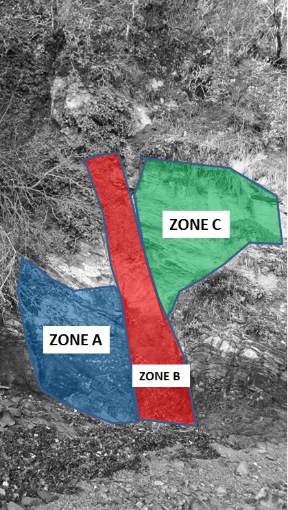
- Question 1 : Décrivez les caractéristiques des zones A, B et C (couleur, taille des grains, présence d'une foliation,...). Déduisez-en la nature des roches de ces zones.
- Question 1: Describe the characteristics of areas A, B and C (color, grain size, presence of foliation, ...). Deduce the nature of the rocks from these areas.
- Question 2 : Quelle est la couleur prédominante de la zone B. A quoi est-elle due ?
- Question 2 : Quelle est la couleur prédominante de la zone B. A quoi est-elle due ?
- Question 3 : En fonction du principe de datation géologique, pouvez-vous dater relativement A, B et C ?
- Question 3 : Depending on the principle of geological dating, can you date relative A, B and C?
Vous pouvez vous loguer sans attendre notre confirmation,
mais vous devez nous envoyer les réponses en même temps via notre profil (
fafahakkai).
S'il y a des problèmes avec vos réponses nous vous en ferons part.
Les logs enregistrés sans réponses seront supprimés.Une photo en Noir & Blanc de vous ou de votre GPS avec la Rance en arrière plan seraient la bienvenue, mais ne sont pas obligatoire.
You can log this cache without waiting for our confirmation, but you must send us the answers at the same time,via our profile (fafahakkai) or by the system of Message Center of geocaching.com.
If there is a problem with your answers we will notify you. The logs recorded without answers will be deleted.
A Black&White picture of you or your GPS with the Rance underground, is welcome, but not mandatory.
Rappel concernant les « Earthcaches »: Il n'y a pas de conteneur à rechercher ni de logbook à renseigner. Il suffit de se rendre sur les lieux, de répondre aux questions ci-dessus et de nous renvoyer les réponses.
Reminder concerning "Earthcaches": there is neither a container to look for nor a logbook to sign. One need only go to the location, answer to the differents quiestions and send us the answers.