Oppidum lutétien du Mont St Pierre
La chapelle à la Vierge, au sommet (photo F. Juignet)
1 – Contexte géologique Geological context
La promenade autour de la butte témoin du mont Saint Pierre est jalonnée de panneaux d’information. Le chemin permet en outre de fouler l’ensemble des étages géologiques composant ce Mont chargé d’histoire.
Depuis les abords des Etangs de Saint Pierre, autour desquels se trouve un panneau récapitulatif de la promenade, vous pourrez traverser les couches et dépôts suivants :
- Alluvions modernes et tourbe, principalement autour des étangs.
- Sables du thanétien supérieur, sur le début de la partie boisée, principalement des sables de Bracheux, contenant des fossiles fragiles.
- Yprésien, au pied du Mont jusqu’à mi-hauteur, comprenant des sables fossilifères du Cuisien recouverts d’une fine couche d’argile de Laon.
- Lutétien, partie supérieure du Mont. Sur une base calcaire souvent très fossilifère.
The walk around Mount Saint Pierre witness hill is dotted with information panels. The road also serves to trample all geological stages which compose this mount full of historical attributes.
Since the area around Saint Pierre ponds, where stand a summary panel of the walk, you can cross the following layers and deposits:
- Peat and modern alluvium, mainly around the ponds.
- Sands of higher Thanetian, on the beginning of the wooded area, mainly sands of Bracheux containing fragile fossil.
- Ypresian at the foot of Mont until halfway, including Cuisian fossil sands covered with a thin layer of Laon clay.
- Lutetian on upper Mont. On a fossiliferous limestone.

Carte géologique (BRGM)
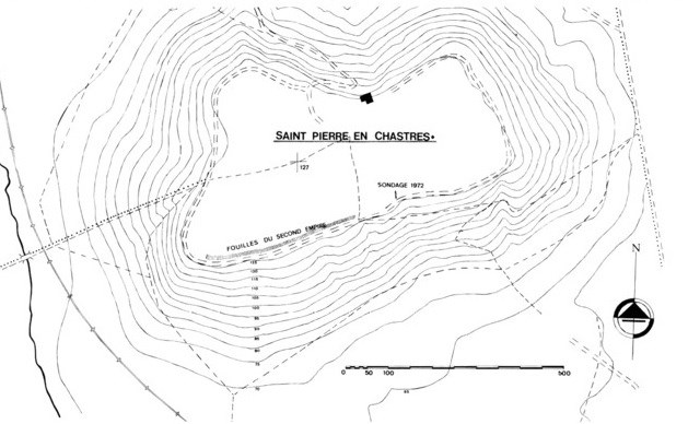
Oppidum de St Pierre en Chastres (d'après Jouve)
2 – Intérêt du site Place interest
Situé sur la commune de Vieux Moulin, le mont Saint Pierre en Chastres est l’un des points culminants de la Forêt de Compiègne. Il s’agit d’un plateau calcaire chargé d’histoire. On dit que ce sont les druides qui les premiers habitèrent ce site.
L’origine du nom de Chastres provient de « castra » qui signifie camp fortifié. Un rempart de terre est dressé tout autour du site, tandis que des vestiges d’un véritable rempart datant de l’âge de Bronze sont encore visibles (-950 à -850 environ).
Les moines bénédictins de Soissons occupent le site à partir du Ixe siècle, puis en 1308 une communauté de célestins (bénédictins à tendance ermite) s’y installe et le premier prieuré est érigé près d’une source miraculeuse. Huit moines y demeureront après la suppression de l’ordre en 1771. Louis XVIII racheta l’enclos après son saccage.
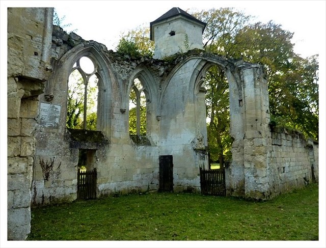
A son sommet, une grande bâtisse construite en 1664, à l’origine une maison forestière, fait aujourd’hui office de résidence d’artistes. Aux alentours, une église en ruine et une petite chapelle de la Vierge beaucoup mieux conservée. L’if de Saint Pierre en Chastres, au sommet, est considéré comme le plus vieil arbre de la forêt de Compiègne (plus de 900 ans).
Located in the town of Vieux Moulin, the Mont de Saint Pierre en Chastres is one of the highest place of the Forest of Compiegne. This is a full of history limestone plateau. Old sayings are pointing out they are druids who first inhabited this site.
The origin of the Chastres name comes from "castra", which means fortified camp. An earthen rampart was erected around the site, while the remains of a true bulwark dating from the Bronze Age are still visible (approximately -950 to -850 BC).
The Benedictine monks of Soissons occupy the site from the ninth century, and in 1308 a community of Celestine (Benedictine with hermit tends) settles there. The first priory is erected near a miraculous spring. Eight monks remain after the suppression of the order in 1771. Louis XVIII bought the pen after his rampage.
At the top, a large house built in 1664, originally a forest house, is an artist residency office today. Nearby are a ruined church and a better preserved small chapel of the Virgin. St. Peter Chastres yew, at the top, is considered as the oldest tree in the forest of Compiègne (over 900 years).
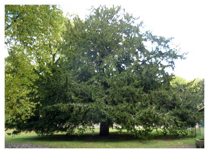
L'if multi-centenaire (photo F. Juignet)
3 - Questions Questions
Loguez cette cache "Found it" et envoyez-moi vos propositions de réponses aux 4 questions suivantes soit via mon profil, soit via la messagerie geocaching.com (Message Center), et je vous contacterai en cas de problème. Inclure au log une photo de vous (optionnel) au cours de votre promenade sans toutefois dévoiler des éléments de réponse.
You can log this cache "found it" and send me by e-mail or message center on geocaching.com your answer propositions to the 4 following questions. In case of problem, I will contact you back. Include a photo of your walk here (optional) without revealing the answers.
|
a) Quelle roche compose le sommet du Mt Saint Pierre ? A quelle altitude culmine t’il (m) ?
What rock made the summit of Mt Saint Pierre? How high is this mount (m)?
b) Au wp 1 se trouve un panneau intitulé « Habitat et Géologie ». Quels sont les trois familles de fossiles marins, retrouvés dans les roches alentours, indiquées sur le panneau ?
In wp 1 is a panel titled "Habitat et Geologie". What are the three indicated families of marine fossils found in rocks nearby (on the panel)?
c) Au wp 2 se situe un bloc de roche (50*60*50 cm environ), sur lequel on aperçoit quelques fossiles. Combien en dénombrez-vous ?
In wp 2 is a (50*60*50cm) block of rock, on which you can see some fossils. How many fossils do you count?
d) Donner le nom de cette roche et expliquer comment ce bloc s’est retrouvé ici avec vos propres mots. Que conclure d’après votre réponse à la première partie de la question a) ?
Give the name of this rock, then explain in your own words how this block arrived here. What conclusion can tou give from your answer to the first part of question a)?
|
4 - Bibliographie Bibliography
- Carte géologique à 1/50000, Compiègne XXIV-11, CGF
http://ficheinfoterre.brgm.fr/Notices/0104N.pdf
- Caze, B., Pacaud, J.-M., L’Eocène du Bassin parisien, Fossiles, Hors Série III pp.5-9 (1977).
http://www.researchgate.net/profile/Jean-Michel_Pacaud/publication/259740346_Locne_du_Bassin_parisien._In__Les_coquillages_de_l'ocne_du_Bassin_parisien_un_trsor_inestimable_vieux_de_plusieurs_dizaines_de_millions_dannes/links/00b7d52d81c42bd184000000.pdf
- Jouve, M. Sondages sur l’Oppidum de Saint Pierre en Chastres, revue archéologique de l’Oise, vol.8, 3, pp 39-44 (1976).
http://www.persee.fr/doc/pica_0752-5648_1976_num_8_3_1069
- Gély, J.-P., le Lutétien : une période charnière de l’histoire du Bassin Parisien, Saga Information, n°284, pp.6-24 (2009)
http://www.saga-geol.asso.fr/Documents/Saga_284_Lutetien.pdf
