 Les cours d'eau de la Lorraine Gaumaise érodent les roches dans lesquelles ils creusent leur vallée pour parfois creuser des méandres.
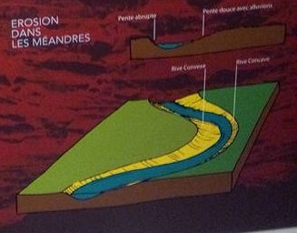
L'écoulement de l'eau est assez lent et les rivièrent développent des sinuosités ou méandres en constante transformation en raison de l'érosion de leurs rives comme les méandres de la Semois.
Le maximum de vitesse du courant se déporte vers l'extérieur des courbures, c'est à dire vers la rive concave du méandre.. L'érosion y est donc renforcée par rapport à la rive convexe où l'eau coule plus lentement et permet le dépôt de sédiments provenants de l'amont et appelées "aluvions".
Au fil du temps, cette érosion entraine un déplacement des méandres. Parfois, des rives concaves tendent à se rapprocher. Les méandres peuvent donc finir par se recouper en isolant des bras de rivières. L'ancien méandre est donc progressivement abandonné.
Pour pouvoir valider cette earthcache :
Vous devrez répondre correctement aux questions suivantes.
Merci d’envoyer vos réponses via mon profil ou via la messagerie geocaching.com, ne les donnez pas dans votre log.
Vous pouvez ensuite loguer la cache "found it", je vous contacterai en cas de problème.
1/ Sur le panneau, quel est le point le plus haut de la carte?
2/ Dans quel sens coule la Semois?
3/ Sur quel cuesta se trouve le point de vue du Menil? (réponse sur le panneau)
4/ Quel est l'altitude ce point de vue? ( voir WP2)
 The waterways of Lorraine rocks Gaumaise erodent In Which they dig Their pay valley Meanders Sometimes digging. The Flow of water is slow enough and rivièrent develop windings e Meanders constantly changing due to erosion their_banks as the meanders of the Semois.
The maximum current speed swerves to the outside of bends, ie toward the concave side of the bend .. Erosion is therefore strengthened compared with the convex side where water flows more slowly and allows coming from the deposition of sediments from upstream and called "aluvions".
Over time, this erosion leads to a displacement of the meanders. Sometimes concave banks tend to approach. So the meandering can end up in rivers intersect arm of insulation. The former meander is gradually abandoned.
To validate this earthcache:
You will need to correctly answer the following questions.
Thank you send your answers via my profile or via geocaching.com mail, do not give in your log.
You can then log the cache "found it", I will contact you in case of problems.
1 / On the panel, which is the most developed of the card?
2 / In which direction flows the Semois?
3 / Which cuesta is the view of the Menil? (Answer on the panel)
4 / What is the altitude that view? (See WP2)