Splash Point I - Tidal Effect EarthCache
Splash Point I - Tidal Effect
-
Difficulty:
-

-
Terrain:
-

Size:  (other)
Please note Use of geocaching.com services is subject to the terms and conditions
in our disclaimer.
This site, known as Splash Point, is one of the most exposed along the South Coast. This Earthcache is designed to teach you a little about the Geology of the place.
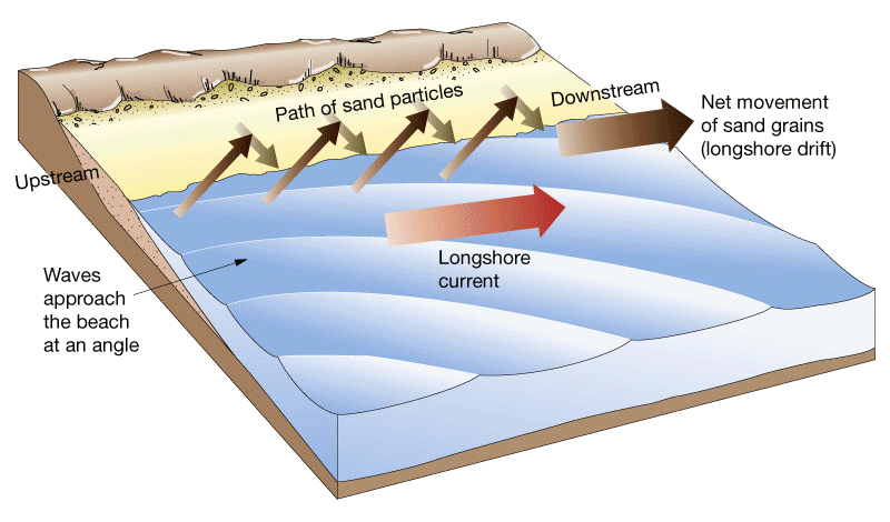
Shingle is moved along the coastline in a process known as Longshore Drift. The prevailing wind blows waves carrying shingle into the beach at an angle of about 45°. This action is known as Swash. The waves then break on the shore and as the water runs back into the sea it carries shingle back down the beach, perpendicular to the angle of the shoreline under the influence of gravity, this is called Backwash. This results in a zigzag motion as the shingle is transported along the coastline. This process means that over time beaches can change shape. Groynes are often built to interrupt the flow of longshore drift, but inevitably some sand and shingle can escape. Longshore drift can form spits were the line of the coast changes sharply, for example at a river estuary.
The diagram below illustrates the effects of Longshore Drift.
Vast quantities of sand and shingle can be moved due to Longshore Drift and you are going to investigate quite how much.
Don’t worry, the maths isn’t that complicated and I will try and walk you through it, so don’t let it put you off doing this cache! (This is the reason for Difficulty Rating of this cache) You are going to need to calculate the mass of shingle that would be moved each year along a given section of the beach if these groynes were not in place. This given section will be between two groynes starting at Waypoint S2.
Firstly we need to know the gradient of the beach. This is effected by particle size but research has shown that the average gradient for a pebble beach is 17°. Now you need to calculate the area of a cross section of the beach. To do this you need to know the height gain over the given area, we will call this ‘h’.
The diagram below (please not it is not to scale) should be of some help where Q4 will be your answer to Question 4.
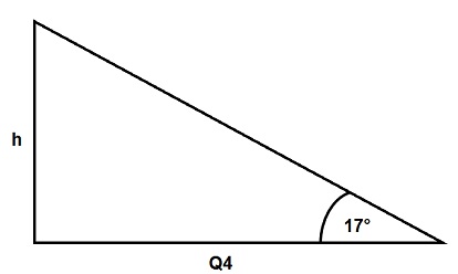
To calculate ‘h’ we can use the following
h = Q4 x tan 17°
Then to calculate the area of the beach cross section you can use the following:
Area = (Q4 x h)/2
To calculate the Volume of the beach you need to multiply the Area by the distance you measure in Question 5.
Given that the mass of Shingle is approximately 1.62 tonnes per cubic metre, multiply this value by the Volume to give you the mass of shingle moved if the groynes were not there.
Due to needing to access the groynes, it is best that you avoid attempting the tasks in the 2 hours either side of high tide.
To log the Earthcache:
To log this cache, you need to visit the published co-ordinates and the additional Waypoints S1 and S2. Once you have completed the required tasks, please then send me your answers through my geocaching profile either via email or through the Message Centre.
The name and GC number of this geocache, the date you visited, and the answers to the questions below.
1. By examining the groynes, look at which side the shingle is higher. Is it on the East Side or the West Side?
2. What does this tell you is the direction of the effect of Longshore Drift at this location?
3. Why do you think this is?
4. By reading the notice board at the given Waypoint S1, you will be able to find out the amount of coastline that would be eroded each year without sufficient protection. How much is this?
5. Go to the groyne at given Waypoint S2. Measure the distance between this groyne and the next one to the East. Then, taking the value you have found in Question 4, use the maths given in the description above to calculate the mass of the shingle moved each year if the groynes were not there?
6. Optionally, please attach a photo of yourself and/or your GPS at the given coordinates. That’s all you have to do. I hope this geocache was enjoyable.
Feel free to log this cache once you have emailed me your answers, I will contact you if there are any issues. Any logs received without the required message will be deleted after 7 days without notice!
Additional Hints
(Decrypt)
Ernq gur grkg va pnpur yvfgvat naq rkcyber ornpu!