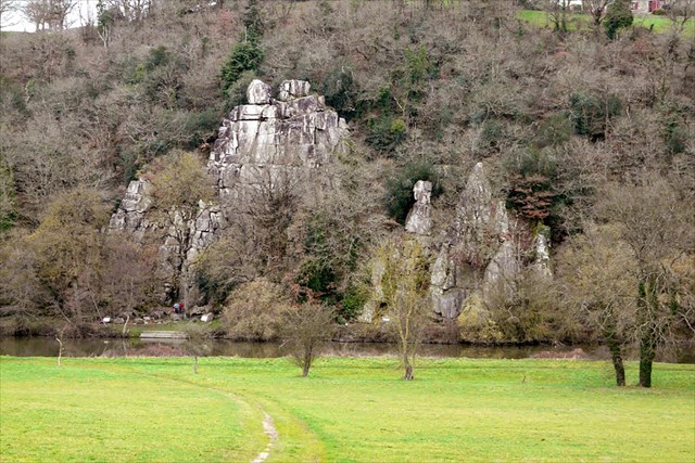
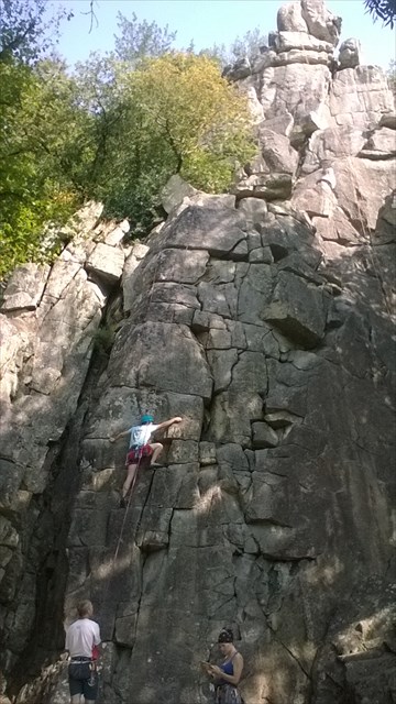
Par cette Earth cache, je souhaite vous faire découvrir un site grandiose sur le roc où, adolescent, j'ai fais mes débuts en escalade sur rochers.
NB : La promenade fait environ 2x1200m (aller+ retour)
Le granite sans aucun doute, est la plus connue des roches. C’est en effet, la roche principale de la croûte terrestre.
Le granite est principalement composé de quartz (cristal gris) de mica noir (c’est lui qui s’oxyde facilement) et parfois de mica blanc, ainsi que de feldspath, sous forme de gros cristaux blancs ou parfois colorés. Les cristaux de quartz sont souvent « informes »: acides, ils ont cristallisé en dernier pour prendre la place restante.
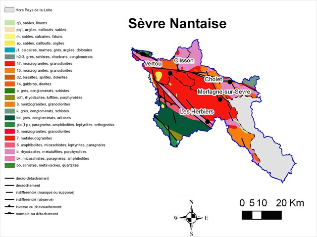
Lors de l'évolution du massif Armoricain, la phase hercynienne, qui débuta il y a 330 millions d'années, est à l'origine des granites qui constituèrent l'ossature d'une montagne puissante.
Les terrains sud-armoricains sont en grande partie constitués de ces granites d'origine hercynienne, injectés le long d'une série de failles
Après la mise en place des plissements de l'orogenèse hercynienne, l'érosion du massif s'est produite durant tout le Mésozoïque et s'est accélérée au Paléocène sous un climat subtropical qui a affecté les roches différemment selon leur dureté.
Les chaos, comme sur ce site du Manis, sont une conséquence de l’érosion sur le granite : les fissures laissent passer l’eau, elles s’agrandissent par altération chimique sous l’action de cette eau, le granite prend progressivement la forme de boules d’abord enterrées dans les débris de l’altération (appelés arène granitique), puis mises à jour par l’érosion durant des millions d'années.
La vallée de la Sèvre Nantaise est issue de ces transformations géologiques.
Pour Valider votre log sur cette Earth cache, vous devrez répondre aux 4 points suivants :
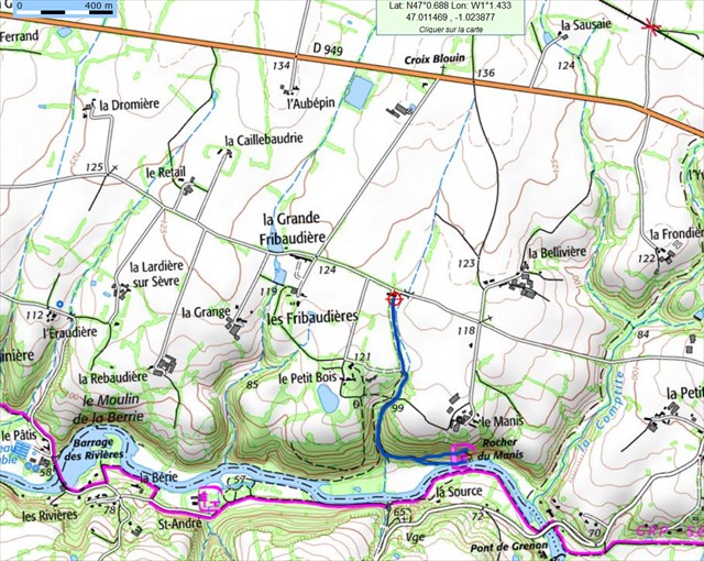
Au WP01: N47°00.350 W01°01.470 WP01 sur un panneau:
Question N°1: quel est le pH du terrain indiqué qui provoque la corrosion.
Pour accéder au WP2, prenez le chemin à gauche de la cabane en bois.
Au WP 02 : N47°00.336 W01°01.210 en haut , vous êtes face au gros bloc du sommet de la falaise , estimez son volume et , la densité du granite est de 2,6,
Question N°2: quel est son poids, estimez à 20% près.
Au WP 03 N47°00.323 W01°01.211 en bas, 1er panneau face au rocher
Question N°3: Quelle est la hauteur maximum du rocher du Manis?
Au WP 04 : N47°00.323 W01°01.202
Question N°4: Quel est le nom du bloc au sommet de la falaise (celle dont vous avez estimé le poids à la question N°1?)
une ou deux photos prouvant votre passage sur ce site remarquable des la vallée de la Sèvre seraient appréciées.
Rappel concernant les « Earthcaches »: Il n'y a pas de conteneur à rechercher ni de logbook à renseigner. Il suffit de se rendre sur les lieux, de répondre aux questions ci-dessus .
Vous pouvez loguer cette Earthcache en "found it" sans attendre notre confirmation, mais vous devrez nous envoyer vos réponses aux questions ci-dessus par messagerie en même temps via la messagerie sur notre profil. S'il y a des problèmes avec vos réponses nous vous en ferons part rapidement afin que vous nous fournissiez d'éventuelles précisions.
Les logs enregistrés sans réponses seront supprimés.
GB:
Granite is the main rock of the Earth's crust.
Granite is composed mainly of quartz (crystal gray) black mica (which is easily oxidized) and sometimes white mica, and feldspar in large and white form or sometimes colored crystals. Quartz crystals are often "shapeless": acids, they crystallized last to take the remaining space.
During the evolution of the Armorican massif, the Hercynian phase beginning there are 330 million years, is the origin of granites which formed the backbone of a mighty mountain.
South Armorican land is largely made up of the original Hercynian granite injected along a series of faults.
After the establishment of folds of the Hercynian orogeny, erosion of the massif occurred during the Mesozoic Era and accelerated in the Paleocene in a subtropical climate that affected the rocks differently according to their hardness.
The chaos, as on this site "le Manis", are a consequence of erosion on granite: cracks let in water, they are expanding by chemical alteration under the action of the water, the granite gradually takes shape buried first balls in the debris of the alteration (called granitic sand), then updated by erosion over millions of years.
The valley of the river "La Sèvre" is the result of these geological changes
Reminder concerning "Earthcaches" There is no container to search for information or logbook. Simply visit the site, to answer the questions above and send us the answers.
You can log in without waiting this Earthcache our confirmation, but you must send your answers to the following questions by email at the same time via email on our profile. If there are problems with your answers we will notify you. The logs recorded unanswered will be deleted.
To Validate your log this Earth Cache, you must meet the following four points:
At the WP01: N47°00.350 W01°01.470 (WP01 is on a plate)
Question No. 1: What is the pH of the ground indicated that causes corrosion.
To access the WP2, take the path on the left of the cabin.
At the N47°00.336 W01°01.210 up, you face the big block the top of the cliff, estimate its volume and the density of granite is 2.6,
Question 2: What is his weight, estimate at 20%.
At the WP 03 N47°00.323 W01°01.211 down the cliff, first panel front of the rock
Question 3: What is the maximum height of the rock Manis (in meters)?
At the WP 04: N47°00.323 W01°01.202 down the cliff, second panel front of the rock
Question 4: What is the name of the block at the top of the cliff (the one you estimated the weight in question N°1?)
Pictures showing your visit in the remarkable places of this riverside would be appreciated..
NB: The walk is about 2x1200m (round trip)