À l’exception du Pouldu et de la crique de Porsac’h, le littoral de Clohars-Carnoët est composé de falaises rocheuses formant une succession de petites pointes rocheuses comme celles de Beg an Tour, Beg Ero Gamm ou de la Vache Noire où se trouve la roche percée.
 With the exception of the Pouldu and the Porsac'h creek, the coastline of Clohars-Carnoët is composed of rocky cliffs forming a succession of small rocky points like those of Beg an Tour, Beg Ero Gamm or the Black Cow Finds the pierced rock.
Contexte géologique / Geological Context
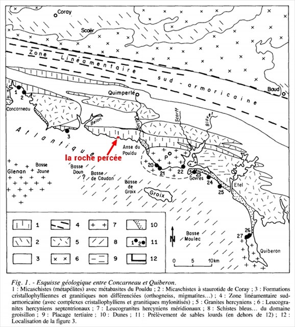
D'un point de vue géologique on trouve au sud un domaine océanique à présent obducté (relatif à l'obduction, à la mise en place d'une partie de la croûte océanique sur une zone de la marge continentale ou de l'arc insulaire) et représenté par les formations groisillones, caractérisées par un métamorphisme de haute pression.
From a geological point of view, we find in the south an oceanic domain which is now obducted (relative to obduction, to the emplacement of part of the oceanic crust on an area of the continental margin or 'Insular arc') and represented by the groisillone formations, characterized by a high pressure metamorphism.
Au nord c'est un domaine continental caractérisé par un métamorphisme de basse pression (micaschistes à staurotide migmatique) et par l'injection de multiples venues granitiques.
In the north it is a continental domain characterized by a low pressure metamorphism (micaschist with a migmatic staurotide) and by the injection of multiple granitic intrusions.
Formation de la roche percée / Formation of the pierced rock
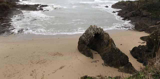
Ce phénomène naturel assez remarquable est avant tout due à l'érosion marine.
This remarkable natural phenomenon is primarily due to marine erosion.
Les principaux agents de l'érosion marine sont les vagues et les courants, auxquels on peut ajouter l'action des embruns salés emportés par le vent ("haloclastie" due à la cristallisation de sel dans la porosité et les fractures).
The main agents of marine erosion are waves and currents, to which one can add the action of salt spray carried away by the wind ("haloclasty" due to crystallization of salt in porosity and fractures).
L'action érosive des vagues résulte des facteurs suivants:
- Un mitraillage par le sable et les gravier transportés, la pression de l'eau contre les parois peut atteindre 30 tonnes/m2 ...
- Une succion lorsque les vagues se retirent
- Des vibrations par suite de chocs successifs (phénomènes de résonance).
The erosive action of the waves results from the following factors:
- A strafing by the sand and the gravel transported, the pressure of the water against the walls can reach 30 tons / m2 ...
- Suction when waves withdraw
- Vibrations due to successive shocks (resonance phenomena).
Pour valider votre découverte / To validate your discovery
Pour rappel dans le cas des earthcaches n'y a pas de boîte à trouver, mais des réponses à apporter !
As a reminder in the case of earthcaches there is no box to find, but answers to bring!
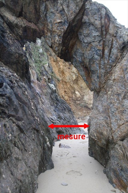
Question 1 : Aux coordonnées de cette earthcache - N 47° 46.122 W 003° 35.254 -, vous vous trouvez devant la roche percée, avec la mer derrière vous (attention en cas de fortes marée vous ne pourrez peut-être pas y accéder !). Munissez vous de votre mètre et mesurez la distance entre les 2 blocs de l'arche (cf. photo)
Question 1: At the coordinates of this earthcache - N 47 ° 46.122 W 003 ° 35.254 -, you are in front of the pierced rock, with the sea behind you (be careful in case of strong tide you may not be able to access it! . Take your meter and measure the distance between the two blocks of the arch (see photo)
Question 2 : Rendez-vous au second waypoint - N 47° 46.140 W 003° 35.245 - et examinez le sol. Que pouvez-vous voir ? Du sable ou des graviers ?
Question 2: Go to the second waypoint - N 47 ° 46.140 W 003 ° 35.245 - and examine the ground. What can you see? Sand or gravel?
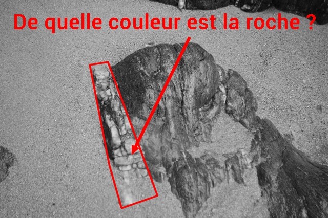
Question 3 : Rendez-vous au troisième waypoint - N 47° 46.140 W 003° 35.219 - au sol vous pouvez retrouver les roches présentes sur la photo ci-dessous. Quelle est la couleur de la roche entourée de rouge ?
Question 3: Go to the third waypoint - N 47 ° 46.140 W 003 ° 35.219 - on the ground you can find the rocks present in the picture below. What is the color of the rock surrounded by red?
Vous pouvez loguer votre découverte en found-it puis m'envoyer vos réponses aux questions par email (ou via le centre de messagerie). Attention : Tout log "found it" sans m'envoyer vos réponses sera supprimé !
You can log your discovery into found-it and then send me your answers to the questions by email (or via the message center). Warning: Any log "found it" without sending me your answers will be deleted!
Sources
Louis CHAURIS - Géologie de la France, n°4, 1988