Introduction: One of the most basic processes in geology is stratification. This is the creation of layers (or bands) of different types of rocks which rest atop one another as they are formed. Strata can form anywhere from hundreds of meters to sub millimeter in thickness. Such formation is illustrated in the picture below. [1]
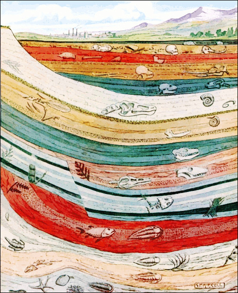
Just about everyone has seen this phenomenon in action in road side cut outs or spectacular images from places such as the Grand Canyon. Strata represent layers of sediment that are deposited and over time transformed into rocks. Rocks formed in this process are referred to as sedimentary for obvious reasons.
However, sometimes something that appears to be a result of stratification is really produced by a radically different process. This Earth Cache will highlight just such an instance.
Igneous Rock: Before discussing the geology seen at the locations highlighted in this Earth Cache, an overview lesson on the formation of igneous rocks is required. Igneous rocks are defined as those formed through the cooling and solidification of magma or lava. Igneous rock may form with or without crystallization, either below the surface as intrusive (plutonic) rocks or on the surface as extrusive (volcanic) rocks. A classification of igneous rocks is provided in the figure below. [2] Rocks in the top row are intrusive in nature. Those in the bottom two rows are extrusive.
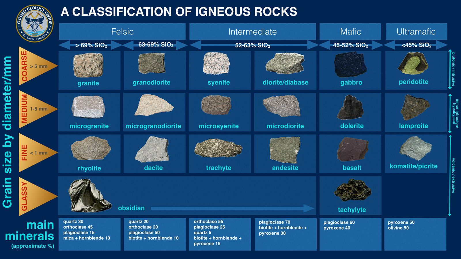
Many minerals make up magma and lava. Depending on which ones are present, igneous rocks can be classified in various fashions. The very top row of the igneous rock chart shows the range of classifications from Felsic to Ultramafic. Ultramafic rocks are composed of usually greater than 90% mafic minerals (dark colored, high magnesium and iron content) and are low in silicate minerals. Felsic rocks (at the other extreme) are those rocks rich in silicate minerals, and rocks which are enriched in the lighter elements such as silicon (Si), oxygen (O), aluminum (Al), sodium (Na), and potassium (K).
Bowen’s Reaction Series: All of these igneous rocks may form out of the same molten cauldron of minerals. Underneath the Earth’s crust molten magma resides under tremendous pressure and temperatures. As this magma cools mineral began to crystallize out in a set order. This order is captured in Bowen’s Reaction Series. A Figure depicting this process is seen below. [3]

Discontinuous crystallization: On the left hand side of the reaction series are Olivine, Pyroxene, Amphibole and Biotite. Which one of these products will be formed depends on the ratio of silicate to other minerals in the melt. If high iron and magnesium concentration minerals are contained in the magma with only limited silicate present, then as the magma cools Olivine (which is low in Silicate concentration) will crystallize out first. If this uses up all the silicate present the process will stop. However, if after the Olivine crystallizes there are still silicate salts present a change will occur as the melt continues to cool. When the melt reaches a temperature in which Pyroxene will form, the Olivine will react with the melt and all transform into Pyroxene. This chemical change will keep occurring as the melt cools and progresses down the left hand side of the chart. In theory this should mean that an excess of silicates in magma will always lead to formation of only Biotite (the final stop in the discontinuous series). However, circumstances can occur which will freeze the process at any stage. For example, if Olivine has formed and the melt is rapidly cooled (by ejection of the magma by the volcano) no time will exist for conversion of the Olivine to other rocks within the series.
Continuous crystallization: This process, shown on the right hand side of the series, does not produce a series of unique rocks. It produces a continuum of one type of rock referred to as plagioclases. Plagioclase minerals have the formula (Ca, Na)(Al, Si)3O8. The highest temperature plagioclase has only calcium (Ca) present. The lowest temperature plagioclase has only sodium (Na). In between, these ions mix in a continuous series from 100% Ca and 0 % Na at the highest temperature, to 50% Ca and 50% Na at the middle temperature, and to 0 % Ca and 100% Na at the lowest temperature. For example, in a basaltic melt, the first plagioclase to form might be 100% Ca and 0% Na plagioclase. As the temperature drops the crystal would react with the melt to form 99% Ca and 1% Na plagioclase, and 99% Ca and 1% Na plagioclase would crystallize. Then this would react to form 98% Ca and 2% Na and the same composition would crystallize. Etc. All of this occurs continuously provided there is enough time for the reactions to take place and enough sodium, aluminum, and silica in the melt to form each new mineral. The end result will be a rock with plagioclases with the same ratio of Ca to Na as the starting magma.
On both sides of the reaction series, the silica content of the minerals increases as the crystallization trend heads downward. Biotite has more silica than olivine. Sodium plagioclase has more silica than calcium plagioclase. Viewing the diagram in reverse (bottom to top) also suggests the sequence in which minerals will melt to form magma when rocks are heated. Once these rocks are exposed at the surface, the stability of minerals is greatest for those that formed at lower temperatures, therefore, olivine, calcic plagioclase pyroxene, will weather first whereas quartz is one of the most stable minerals at the surface under weathering conditions.
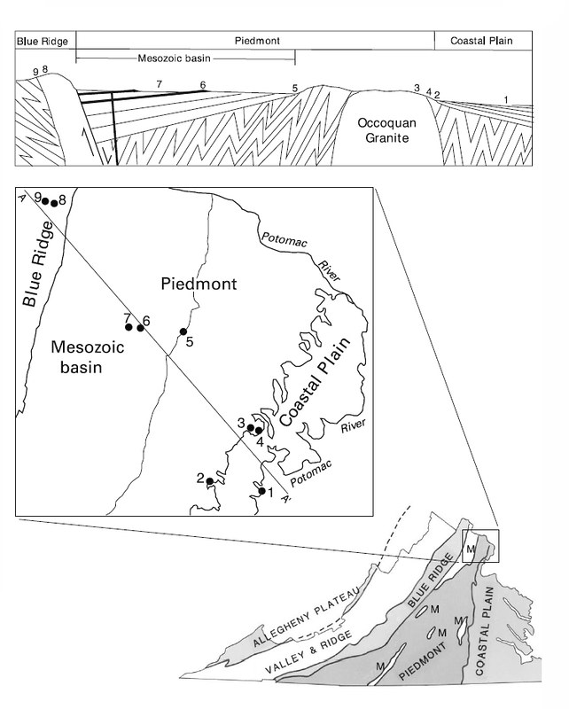
Occoquan Granite: This Earth Cache will focus on two of the rocks which are formed at the very bottom of Bowen’s Series (Granite and Quartz). This region of Northern Virginia possesses a particular granite known as “Occoquan” Granite. Between the Piedmont and Coastal plain geologic regions of Virginia along the Occoquan basin resides a major outcrop of Occoquan Granite. This granite is attributed to a volcanic arc that existed during the early Paleozoic era. A map of the Occoquan Granite zone is seen in the figure below. [4] The number 3 on the charts represents roughly the area of exploration for the Earth Cache.
Excellent exposures of this granite are found on Occoquan Run, from Occoquan village to the forks of Bull Run, at Davis Ford bridge over Occoquan Run, at Blands Ford bridge, and at numerous other places throughout the area. [5] Occoquan granite is marked by considerable variation in its composition and texture from place to place. In all developments it is highly siliceous in nature, as shown by an unusually large content of quartz. The color is irregular greenish gray, with feldspar and quartz in coarse grains as the recognizable minerals. Darker constituents are not identified by the unaided eye. The quartz and feldspar grains frequently exceed one-fourth inch in dimension.
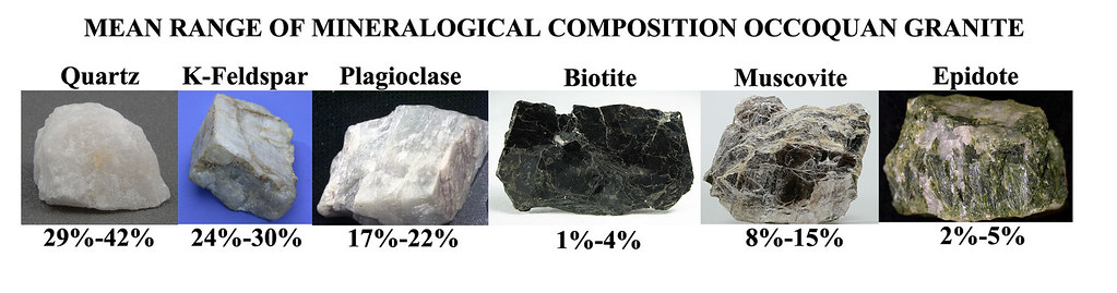
Even though the exact composition of Occoquan Granite can vary, some research has been conducted on its average mineral composition. The table below shows analysis by Seiders et. al. [6]
Waypoint Descriptions:
The two waypoints can be visited in any order, but the listed main coordinates will lead you to the major outcropping of Occoquan Granite of interest.
Waypoint 1: Here both Occoquan Granite and native Quartz can be seen side by side. The large boulder is an outcrop of granite. The more numerous boulders are pure quartz (so indicative of ground cover in this area). As mentioned earlier, quartz is more durable than granite. Cracks and fractures can be seen in the granite boulder where erosion is occurring. As the granite is broken down it leaves behind smaller bits of its constituent minerals. Quartz, being the most robust will remain as grains of sand. However, Feldspar (a prime constituent of Occoquan Granite) breaks down into the clay mineral kaolin in one of the important weathering processes. [7] This weathering process is responsible for the high clay content in the soil seen in the Occoquan River shed.
Question 1: Will the boulder on the far left vanish first or last given enough time? Why?
Earth Cache Location: In kayaking the Occoquan river from the damn on the eastern boundary to the bridge near Bull Run marina, the outcrop of Occoquan Granite at the listed coordinates was the only one found to exhibit a significant quartz vein. The main coordinates lead right to this feature.
Question 2: What are the dimensions of the quartz vein (length and thickness)?
Question 3: What colors are the quartz vein and the surrounding granite?
Question 4: Which do you believe is older, the granite or the quartz vein? Why?
Question 5: Knowing this vein was not created by stratification, what process do you believe created it?
References:
1. http://www.wpclipart.com/science/earth/geological_strata.png.html
2. https://oxfordgeology.wordpress.com/tag/classification-of-igneous-rocks/
3. http://www.geologyin.com/2014/09/how-does-bowens-reaction-series-relate.html
4. Geology of the National Capital Region – Field Trip Guidebook, Joint Meeting of the Northeast and Southeast Sections Geological Society of America, Tysons Corner, VA, March 24-27, 2004, Circular 1264, U.S. Department of the Interior.
5. Geology of the Gold-Pyrite Belt of the Northeastern Piedmont Viginia, Bulletin 30 State of VA Conservation and Development Commission Virginia Geological Survey, John T. Lonsdale, 1927.
6. V. M. Seiders, R. B. Mixon, T. W. Stern, M. F. Newelt, and C. B. Thomas , Age of Plutonism and Tectonism and a New Minimum Age Limit on the Glenarm Series in the Northeast Virginia Piedmont near Occoquan, Am J Sci., May 1, 1975 275:481-511.
7. Mitchell, J.K., and Soga, K., Fundamentals of soil behavior, Third Ed., John Wiley and Sons, Inc., 2005, P. 200-204.


CONGRATS TO Awesnap

Most Outstanding Location/Scenery
Best Earthcache