The landscape of this area of Washington is dominated by layer upon layer of volcanic history and nearly everything you look upon is formed, controlled, or shaped by volcanic processes. This portion of the Chinook Scenic Byway is a fantastic example of the dynamic nature of the area. From this cache location south to the Nile Road is a series of volcanic outcrops that tell just a small portion of the history of the area.
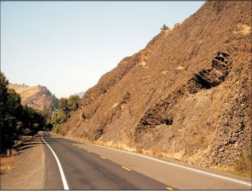
The rocks across from the cache are a portion of the Columbia River Flood Basalts, a series of extensive lava flows that erupted from an area of Southeast Washington and Northeast Oregon from 17.5 to 6 million years ago. These lava flows were so extensive that the area now covers portions of five states and makes up the area known as the Columbia Plateau. The flows you see before you emerged from southeast Washington along valleys now long gone and before the Cascade Mountains even existed.
The Columbia River Flood Basalts are subdivided into five groups. The area surrounding you is part of the Grande Ronde Basalt flows, which erupted between 17 and 15.6 million years ago and comprises about 85 percent of the total flow volume.
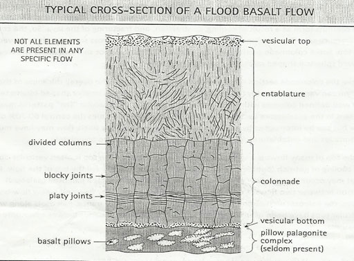
Where you are standing, the Grande Ronde Basalt flows are divided into six individual basalt flows that are separated by what are known as interbeds (periods of sedimentary deposits formed between lava flows). These flows are geochemically all classified as basaltic andesite. Looking to the east (across the highway), the basaltic flow you are looking at is known as the Cohassette lava flow. Looking southeast you can see what is known as the Rocky Coulee lava flow. The Rocky Coulee lava flow is dipping to the southwest, and you are able to see the cross section including the columnar jointing present within the flow. Please take a moment to compare what you see with the idealized cross section. See if you are able to identify each feature.
The yellowish to brownish fine-grained tuff and sandstone located between these two lava flows is known as an interbed, and was deposited in a period between the lava flows.
There are very few good places to stop along this section of Highway 410 to view these deposits, but please take the time to look at them as you drive past. I have provided an additional pullout at the southeast end of these outcrops where you can stop and look back to the northwest.

2016 was the 100th anniversary of the National Park Service, and to celebrate, Visit Rainier and WSGA are hosting the Visit Rainier Centennial GeoTour - 100 caches placed in and around Mount Rainier National Park. The geocaches highlight the rich history, scenic wonders, quaint communities, and hidden gems of the Rainier region.
The caches were released in four series of 25 caches each during 2015 and 2016. Participants record their finds in passports, which may be turned in upon completion of each series to receive a prize. Each series has a unique prize, and a commemorative geocoin is awarded to those finding all 100 GeoTour caches (while supplies last).
The Rainier Centennial GeoTour is sponsored by Visit Rainier and Washington State Geocaching Association (WSGA). We hope you enjoy touring the Mount Rainier area as much as we do!

