Welcome to one of Washington State's newest natural (not man-made) lakes!
Lake Kapowsin celebrated its 500th birthday in 2002-03, and the story of its existence is the reason for this earthcache. It was created by the Electron Mudflow, which geologists have dated to the years 1502-03 based on tree rings found in the debris flow. The mudflow originated on the slopes of Mount Rainier in the Sunset Amphitheater region, high on the west side of the mountain.
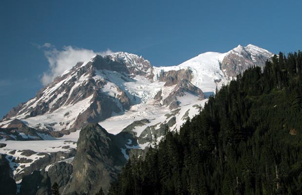
The source area of the debris flow is a bit left of center in the image below. Note how the area around Sunset amphitheater is not smoothly polished, but still somewhat rough. The Puyallup Glacier hasn't had time to do its work and smooth out all of the scars in the amphitheater since it reformed in the area following the collapse.
Geologists classify mud and debris flows (the technical term is the Indonesian word lahar) from volcanoes into two types. Cohesive lahars form because over time the heat from the volcano chemically alters the rock, weakening it and breaking it into weaker clay. Eventually something triggers the lahar and a large mass of the volcano gives way all at once. These types of lahars often act like “wet concrete” as they flow downstream, destroying everything in their path. These types of lahars can travel great distances. The massive lahar that flowed away from Mt. St. Helens down the Cowlitz River in 1980 was a cohesive lahar as was the Oso Landslide on the Stillaguamish River (though the Oso event obviously wasn't a cohesive volcanic lahar, just a cohesive landslide). Noncohesive lahars, on the other hand, have less clay and are often formed by heavy rainfall, volcanic eruptions that melt glaciers and snow, or water-saturated soils giving way. The Kautz Creek lahar of 1947 is a good example of this type of lahar. Both types of lahars happen at Mount Rainier.
Once lahars stop flowing and settle, they create a layered pattern, with the largest and heaviest items at the bottom and smaller, lighter particles on top. This happens naturally as the heavier chunks are pulled by gravity down through the very viscous fluid and settle more quickly.
The Electron Mudflow does not seem to be associated with an actual eruption of the mountain. Unlike the 1980 eruption of Mount St. Helens, which generated an immense cohesive lahar that flowed down the Toutle River, the Electron Mudflow seems to have "just happened." It may have been triggered by an earthquake, but there are no remnants or even trace amounts of ash from an eruption at that time. The rock that makes up the west flank of Mount Rainier is not strong; the lava flows and eruptions are not well-bonded rock to start with, and they are constantly heated from within. That, along with the large amount of water that seeps into the rock, creates conditions where geochemical reactions occur that weaken the rock even further. At some point, the rocks are simply not well-bonded enough to resist the force of gravity and they collapse.
The Electron Mudflow is only one of a large number of similar events that have happened around Mount Rainier. Geologists have identified at least 60 minor and seven major debris flows in the Holocene era (last 10,000 years) from Mount Rainier that have left significant deposits outside the park boundary. The largest of these was the Osceola Mudflow, which reached Puget Sound about 5,600 years ago. That mudflow and its remnants are described in Rainier100 4: Osceola Mudflow.
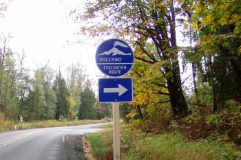
As these significant debris flows have happened numerous times in the past, geologists know that they will happen again in the future. On average, one of these very large debris flow events happens about every 1,400 to 1,500 years, though they could happen at any time - the amount of time since the last event is not an indication of how long it will be until the next one. Statistically, there is a 3-4% chance that a large debris flow from Mount Rainier will happen in the next 50 years. Emergency planners are aware of the potential hazard and that's why you see signs like this one in areas where debris flows might occur.
The Electron Mudflow came down the Puyallup River and spread out as it entered the Puget Sound lowlands. At Electron, the depth of the flow was estimated to be about 15 meters (50 feet), and the mudflow dammed Kapowsin Creek as it flowed into the Puyallup River, forming Lake Kapowsin. As the flow traveled farther downstream, it continued to spread out, but still buried everything in its path. The present day town of Orting sits on top of about 6 meters (20 feet) of the debris flow.
Lake Kapowsin hosted a roaring logging town in the early part of the 20th century, with nearly 1,000 people living there at the height of its popularity. The loggers found a ready supply of timber standing in the lake, and some of it was cut down to feed the mills. As the logging industry dwindled, so did the town, and now little remains of its former glory as fire, nature, and time have claimed much of the former town. One particularly interesting factoid is that there is apparently a train engine that fell into the lake and is still there buried in the silt.
To Log This Earthcache
Visit the posted coordinates. Note that you need a Discover Pass to park at the boat launch. Answer the questions below based on your observations in either an email or geocaching.com message to the cache owner. If the answers are for more than one geocacher in your group, please list all of the people in the group.
- Wander out onto the boat dock. Look up and down the lake and look for any sort of indication that this lake is relatively new. There are clues which are visible in the lake itself that provide a good indication of how new this lake is. What signs do you see that the lake is relatively new?
- After reading the text description above, do you think the Electron lahar was a cohesive or non-cohesive lahar? Explain your thought process.
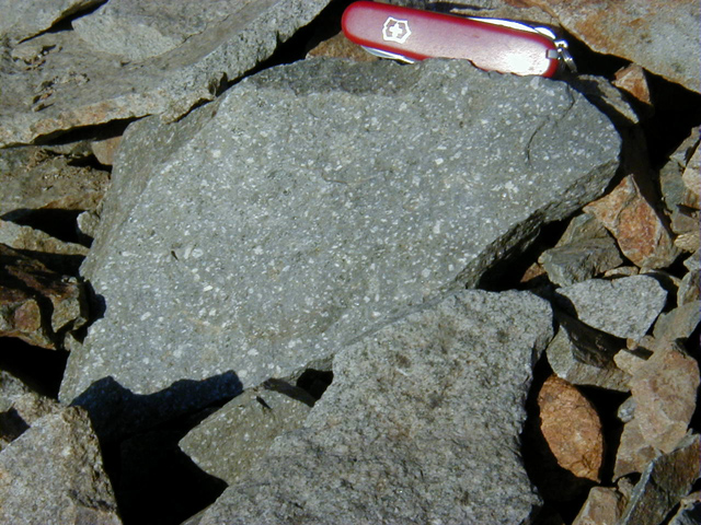
- Note the small boulders that are placed along the side of the boat launch. These boulders are made from granite, which is the base bedrock found on the hills above the lake. They were placed in this location by the Washington DNR when they built the boat launch. Wander along the shoreline far enough away to get away from these boulders, and look for rocks and debris that may have come from the debris flow. The rocks you are looking for are not granite like the small boulders near the boat launch, but rather andesite from Mount Rainier - see picture below. Can you find any andesite? If so, describe the piece you found and how it differs from the granite boulders near the boat ramp. If you can't find any andesite, why do you think that might be? Explain your reasoning.
- While not required, pictures of your visit are welcome!
References
- Roadside Geology of Mount Rainier National Park and Vicinity, Patrick Pringle (2008)
- Mount Rainier National Park: Geologic Resource Evaluation Report, NPS Natural Resource Program
- Significant Lahars at Mount Rainier, USGS Volcano Hazards Program
2016 was the 100th anniversary of the National Park Service, and to celebrate, Visit Rainier and WSGA hosted the Visit Rainier Centennial GeoTour - 100 caches placed in and around Mount Rainier National Park. The geocaches highlighted the rich history, scenic wonders, quaint communities, and hidden gems of the Rainier region. Participants received geocoin and pathtag prizes for finding all the caches.

