Présentation
Le lac Genin est un lac de moyenne altitude du massif du Jura. Il se situe au milieu d'une forêt typiquement jurassienne, composée de sapins, d'épicéas et de feuillus. Le site est surnommé "le petit Canada du Haut-Bugey" et est classé site pittoresque depuis le 1er mars 1935.
Géologie
Ce lac est situé dans une dépression du synclinal de Charix orienté NNE-SSW et segmenté par des fractures NW-SE. Il est alimenté par les eaux ruissellement et des venues d’eaux souterraines. Le trop-plein s’écoule vers le Sud par un réseau souterrain dont l’entrée est bien visible.
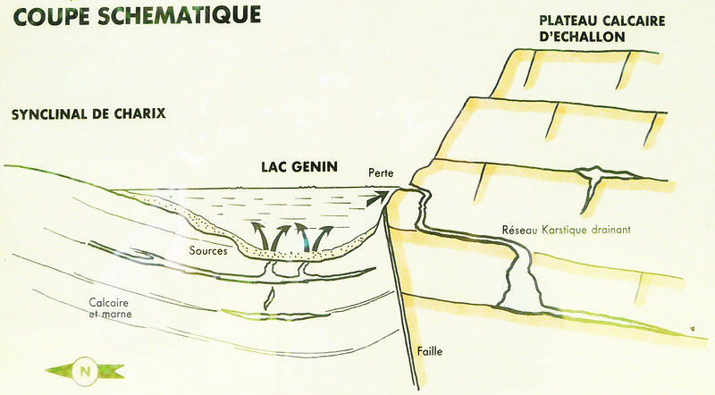
L’origine de la dépression est probablement karstique avec surcreusement ultérieur du glacier jurassien et dépôt de sédiments argileux. Un forage à la tarière à main a traversé une couche de tourbe (1 m au moins) reposant sur un calcaire poreux jaune (travertin) à coquilles de mollusques et restes d’algues (oogones de Characées). Au-dessous viennent probablement des dépôts glaciaires qui assurent l’étanchéité de la dépression.
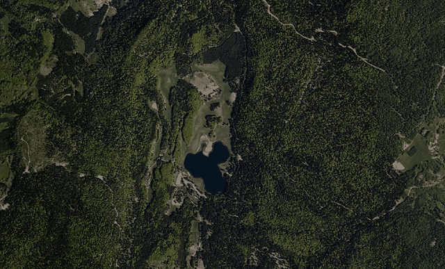
La dépression du Lac Genin dans le stnclinal de Charix (cliché IGN)
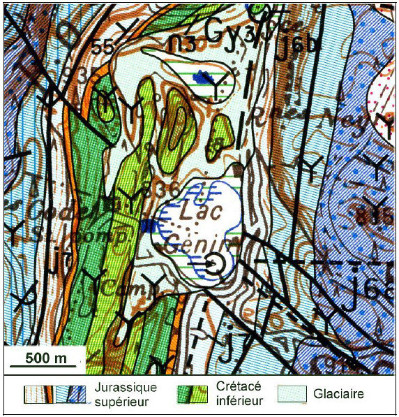
Extrait de la carte géologique à 1/50 000 Nantua (Mangold et al., 2004) :
le lac est situé dans une dépression synclinale (calcaires crétacés et dépôts glaciaires)
bordée de chaque coté par un anticlinal de Jurassique supérieur
La earthcache

Pour pouvoir valider cette earthcache, vous devrez répondre aux questions suivantes à partir des informations de cette page et de celles relevées sur le panneau aux coordonnées indiquées.
Merci d’envoyer vos réponses via mon profil ou via la messagerie geocaching.com, ne les donnez pas dans votre log.
Vous pouvez ensuite loguer la cache "found it", je vous contacterai en cas de problème.
1) Quelle est la double origine de la formation de la dépression où s'est formé le lac ?
2)A quelle altitude se situe le lac ? Quelle est sa surface ?
3) Quelle épaisseur de glace moyenne et maximum peut se former sur le lac l'hiver ?
4) D'après la coupe schématique, quel rôle important, d'un point de vue hydrologique, joue la faille séparant les 2 structures ?
5) Comment appelle-t-on l'endroit où le trop-plein s'écoule dans le réseau karstique ?
6) Quel type de roche et de quelle époque affleure par endroits sur la route d'Oyonnax ?
7) Vous pouvez également ajouter à votre log une photo de vous ou de votre gps devant le lac (facultatif mais grandement apprécié).
Introduction
The Genin lake is a medium-altitude lake in the Jura massif. It is in the middle of a typical Jura forest, composed of fir, spruce and hardwoods. The site is called "the little Canada of Upper Bugey" and is classified picturesque site since 1 March 1935.
Geology
This lake is located in a de pression of the synclinal of Charix oriented NNE-SSW and segmented by NW-SE fractures. It is fed by runoff water and came from groundwater. The overflow drains to the south by an underground network whose entrance is visible.
The origin of depression is likely karst with further deepening of the Jura and glacier deposit clay sediments. A drill hand auger went through a peat layer (at least 1 m) resting on a yellow porous limestone (travertine) shells of shellfish and remains of algae (oogonia of Characeae). Below are probably glacial deposits which seal of depression.
Depression of Genin lake in Charix syncline (IGN picture)
Extract of the geological map 1:50 000 Nantua (Mangold et al., 2004):
the lake is located in a synclinal depression (Cretaceous limestone and glacial deposits)
bordered on each side by a Jurassic anticline.
The earthcache
To be allowed to validate this earthcache, you will have to answer the following questions from the information ont the sign at the specified coordinates.
Thank you for sending your answers via my profile or the geocaching.com messaging, don't take it in your log.
You may then post your log "found it", I shall contact you in case of problem.
1) What is the double origin of the formation of depression that formed the lake?
2)How high is the lake? What is its surface?
3) How mean and maximum thickness of ice may form on the lake in the winter?
4) According to the schematic section, what role, a hydrological standpoint, plays the fault separating the two structures?
5) How do we call the place where the overflow flows into the karst system?
6) What type of rock and what time outcroppings in some areas on the road to Oyonnax?
7) You may also add to your log a photo of you or your GPS in front of the lake (optional but greatly appreciated).