Skip to content

Lumachelle du Burdigalien de l'étang de Berre EarthCache

Hidden : 3/6/2017
Difficulty:
2 out of 5
Terrain:
1.5 out of 5

Size: Size:   other (other)

Join now to view geocache location details. It's free!

Watch

How Geocaching Works

Please note Use of geocaching.com services is subject to the terms and conditions in our disclaimer.

Geocache Description:


DESCRIPTIF EN FRANCAIS (FR) : (SEE ENGLISH DESCRIPTION (EN) BELOW)

DESCRIPTION GEOLOGIQUE

Ce site singulier, situé au lieu-dit "Janone", entre Istres et Miramas, le long de la RD16, correspond à une zone protégée depuis 1985 référencée sous le nom de "coupe géologique de la rive occidentale de l'étang de Berre".

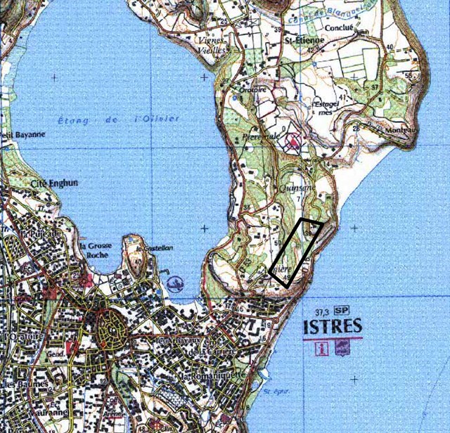
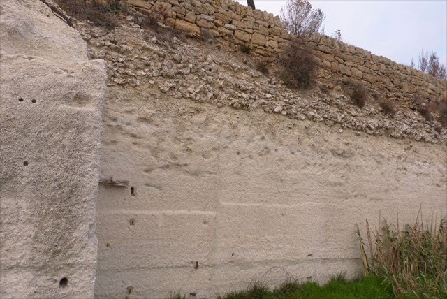
On y observe, sur 200 mètres de long, et face à une zone de baignade autorisée mais non surveillée de l'étang de Berre, une coupe géologique dont la particularité est une accumulation de grosses huîtres fossiles datant de 16 à 20 millions d'années, que l’on appelle "Lumachelle", située dans sa partie supérieure.

Depuis le parking (= coordonnées PZ), on observe la coupe caractéristique du Miocène (Burdigalien), qui montre des fossiles attestant de la présence d’une ancienne mer chaude, peu profonde, là où se trouve maintenant l’étang de Berre. Elle indique l’évolution progressive d’un milieu littoral périrécifal agité (base de la coupe) vers une période plus calme (sommet de la coupe).

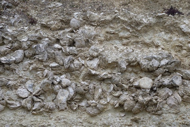
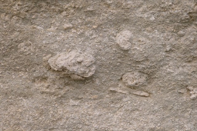
Au-dessous de la couche supérieure constituée par l'accumulation de ces grosses huîtres fossiles appelées "Ostrea squarossa", on observe une formation détritique plus fine constituée d'une multitude de débris bioclastiques (débris d'organismes fossiles), de couleur blanc-jaunâtre.
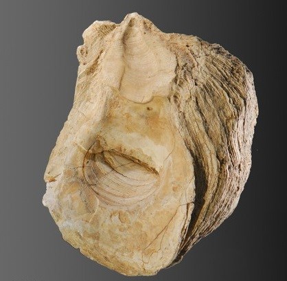

Ostrea squarossa

Si vous observez bien cette formation inférieure, vous pouvez y reconnaitre des fragments des organismes ci-dessous :

1/ Algues rouges ramifiées (Lithothamniées), qui forment des encroutements plus ou moins branchus et blancs :

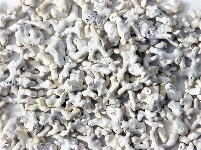
2/ Algues rouges calcaires en boules (Lithothamniées et Mélobésiées) :

3/ Dents de requins de type "Mégalodon". Ces requins pouvaient mesurer jusqu'à 10 mètres de long :

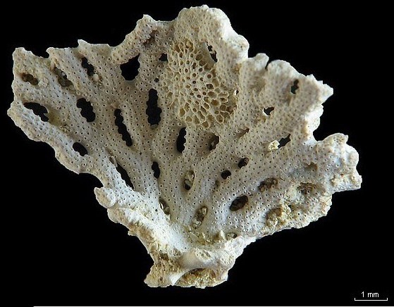
4/ Bryozoaires branchus, favorisant la construction des récifs coraliens :

5/ Lamellibranches bivalves de type "Gigantopecten ziziniae" :

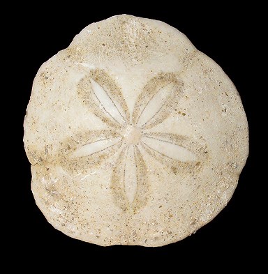
6/ Oursins plats de type "Scutella" :

Recommandations pour une gestion raisonnée du patrimoine naturel : conserver ces lieux intacts, en évitant les mouvements de terrain, les prélèvements de matériaux, les remblais et les déblais. Ne pas faire de publicité particulière autour de la présence de fossiles sur le site, ce qui suffit souvent à éviter tout acte de vandalisme mercantile.

POUR VALIDER CETTE EARTHCACHE

Rendez-vous sur le parking (= coordonnées PZ). De là, la coupe géologique est bien visible. Prenez le temps de faire d’intéressantes observations.

Pour se conformer aux directives éducatives des Earthcaches, vous devez répondre aux questions suivantes, qui peuvent nécessiter quelques recherches sur le terrain et dans le descriptif ci-dessus.

Loguez cette Earthcache "Found It" et envoyez-nous vos réponses soit par mail via notre profil, soit par la messagerie géocaching (message center), nous vous contacterons en cas de problème. Tout log sans réponses consécutives sera effacé.

QUESTIONS :

Q1- Aux coordonnées PZ (= N43°31.117 E05°00.379), estimez l'épaisseur de la couche supérieure constituée par la lumachelle à Ostrea ?

Q2- Quelle est la longueur moyenne de ces Ostrea ?

Q3- Juste au-dessous de la lumachelle à Ostrea, on devine un niveau moins épais, très blanc, constitué essentiellement par l'un des organismes fossiles décrits ci-dessus (1 à 6). De quel organisme s'agit-il, et décrivez ce que vous y voyez ?

Q4- Rendez-vous maintenant de l'autre côté de la route (attention aux voitures !!), en bordure de l'étang de Berre, aux coordonnées Q4 (= N43°31.139 E05°00.423).

Vous pouvez y observer un estran rocheux qui correspond au niveau inférieur de la coupe géologique décrite ci-dessus. Dans ce niveau, vous pouvez y voir de gros fossiles de l'un des organismes décrits ci-dessus (1 à 6). De quel organisme s'agit-il ?

Q5- Facultatif : Prenez une photo de vous ou de votre GPS avec la coupe géologique ou l'étang de Berre en arrière plan, ça nous fera plaisir, et ça validera votre passage sur le terrain.

***********************
***********************

ENGLISH DESCRIPTION (EN) :

GEOLOGICAL DESCRIPTION

This singular site, called "Janone", between Istres and Miramas, along the RD16, corresponds to a protected area since 1985 referenced as the "geological cut of the west bank of the Etang de Berre".

There is a geological section of 200 meters long, facing an authorized but unsupervised bathing area of the Etang de Berre, the peculiarity of which is the accumulation of large fossil oysters dating from 16 to 20 million years ago, called "Lumachelle", located in its upper part.

From the parking (= PZ coordinates), you can see the characteristic cut of the Miocene (Burdigalien), which shows fossils attesting to the presence of an old warm and shallow sea, where now is the pond of Berre. It indicates the progressive evolution of an agitated peri-reef coastal environment (base of the cut) towards a calmer period (top of the cut).

Below the upper layer of the accumulation of these large fossil oysters called "Ostrea squarossa", there is a finer detritic formation consisting of a multitude of bioclastic debris (fossil organisms) white-yellowish.


Ostrea squarossa

If you observe this lower formation, you can recognize fragments of the following organisms :

1/ Red branched algae (Lithothamnies), which form more or less branchus and white encroachments :

2/ Red limestone algae in balls (Lithothamnies and Mellobésies) :

3/ Teeth of sharks of the "Megalodon" type. These sharks could measure up to 10 meters long :

4/ Bryozoa branchus, favoring the construction of coral reefs :

5/ Bivalve Lamellibranchs of the "Gigantopecten ziziniae" type :

6/ Flat sea urchins of the "Scutella" type :

Recommendations for a rational management of the natural heritage : to preserve these intact spot, avoiding the movements of the ground, the taking of materials, the embankments and the cuttings. Do not advertise people around the presence of fossils on the site, which is often enough to avoid any act of mercantile vandalism.

TO VALIDATE THIS EARTHCACHE

Go to the parking (= PZ coordinates). From there, the geological section is clearly visible. Take time to make interesting observations.

To comply with the educational guidelines of Earthcaches, you should answer the following questions, which may require some research directly on the spot or in the geological description above.

Log this Earthcache "Found It" and send us your answers either by mail on our profile, or by geocaching message center, we will contact you in case of problems. All unanswered log will be deleted.

QUESTIONS :

Q1- At the coordinates PZ (= N43°31.117 E05°00.379), estimate the thickness of the upper layer constituted by the Ostrea accumulation ?

Q2- What is the average length of these Ostrea ?

Q3- Just below the Ostrea accumulation, we can see a thicker level, very white, consisting essentially of one of the fossil organisms described above (1 to 6). Which organism is it, and describe what you see there ?

Q4- Now go to the other side of the road (beware of the cars !!), on the edge of the pond of Berre, at the coordinates Q4 (= N43°31.139 E05°00.423).

You can see a rocky foreshore that corresponds to the lower level of the geological section described above. In this level, you can see large fossils of one of the organisms described above (1 to 6). Which organism is it ?

Q5- Optional : Take a picture of you or your GPS with the geological cut or Berre pond in the background, it will be a pleasure for us, and it will validate your presence on the spot.

Additional Hints (No hints available.)