Hveramel - Hot Spring Area
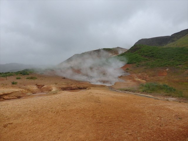
The Hveramel Hot Spring Area is located near Hveragerdi in Iceland. It is a high temperature area, showing hot springs, mud pools and solfatares. There are more than 30 hot springs located in this area, some of them are used to heat glass houses, baking bred in bakeries or even for cooking in a restaurant. The geological background of Hveramel area is that cold ground water seeps down to magma intrusions where it is heated and transformed into steam, afterwards it comes back to the surface. Along with the steam comes fumarole gas, it contains sulphur hydroxide which is responsible for the typical "hot spring smell" most people know. In Hveramel, like in other hot spring areas, sulphur deposits are formed when fumarole gas mixes with air. Besides the sulphur deposits a mixture of silica and gypsum form around the fumaroles. In mud pots, which can observed in the Hveramel area, fumarole gas rises through surface water, producing sulphuric acid which makes the water acid. Rock and soil dissolve in this acid water, producing the mud which is typical for the mud pots and their surroundings.
High Temperature Areas
High-temperature areas are located within the active volcanic zones or marginal to them. They are mostly on high ground. The rocks are geologically very young and permeable. As a result of the topography and high bedrock permeability, the groundwater table in the high-temperature areas is generally deep, and surface manifestations are largely steam vents. Hydrogen sulphide present in the steam tends to be oxidised at the surface by atmospheric oxygen, either into elemental sulphur, which is deposited around the vents, or into sulphuric acid, which leads to acid waters altering the soil and bedrock.
The internal structure of fossil high-temperature systems can be seen in Tertiary and Quaternary formations, where erosion has exposed rocks that were formerly at a depth of 1-3 kilometers. The system's heat source is generally shallow magma intrusions. In the case of high-temperature systems associated with central volcanic complexes the intrusions often create shallow magma chambers, but where no central volcanoes have developed only dyke swarms are found. Intrusive rocks appear to be most abundant in reservoirs associated with central complexes that have developed a caldera.
The boiling point of water depends on the hydrostatic pressure. As the pressure increases with depth the temperature needed for the water to boil rises along a curve that is called the boiling point curve.
Hot Springs
A hot spring is a spring produced by the emergence of geothermally heated groundwater that rises from the Earth's crust. There are geothermal hot springs in many locations all over the crust of the Earth. While some of these springs contain water with a safe temperature for bathing, others are so hot that immersion can result in injury or death.
Mud Pots
A mudpot or mudpool is a sort of acidic hot spring or fumarole with limited water. It usually takes the form of a pool of bubbling mud. The acid and microorganisms decompose surrounding rock into clay and mud.
The mud of a mudpot takes the form of a viscuos, often bubbling, slurry. As the boiling mud is often squirted over the brims of the mudpot, a sort of mini-volcano of mud starts to build up, sometimes reaching heights of 3–5 feet. The mud of a mudpot is generally of white to greyish color, but is sometimes stained with reddish or pink spots from iron compounds.
Solfatares
A solfatare or fumerole is an opening in Earth's crust, often in the neighborhood of volcanoes, which emits steam and gases such as carbon dioxide, sulfur dioxide, hydrogen chloride and hydrogen sulfide.The steam forms when superheated volcanoes water vaporizes as its pressure drops when it emerges from the ground. Solfatares are fumaroles that emit sulfurous gases.
Your task to log this Earthcache as found:
Walk along the line near the earthcache coordinates (without crossing it) and have a closer look to the area. According to the description below, what types of geothermal geomorphological features can be observed? Give me a short description in your own words - what do you think how this features have been formed? Give me a short description of the soil - which colours can be observed? What do you think where these different colours are coming from? Is the ground warm or cold - and why do you think it is like it is?
Optional you can add a picture of you or your GPS unit near the site!
Attention: There is no need to wait for log permission! You can log the cache as found after you sent me the answers - if there's something wrong, I'll contact you!
Caution - this is a hot spring area! In this area there are numerous dangerous mud springs. New springs are being formed continually without clear signs on the surface. Always keep on paths and respect dangerous zones! Don't walk close to or between the springs!
Have fun and enjoy the location!
Sources:
www.nea.is
www.wikipedia.org