Le hameau de Jacob-mesnil situé sur la commune de Bretteville-sur-Laize présente de nombreux affleurements, mais est également la localité où a été définie la discordance cadomienne par L. Bertrand en 1921.

Poudingue de base Cambrien:
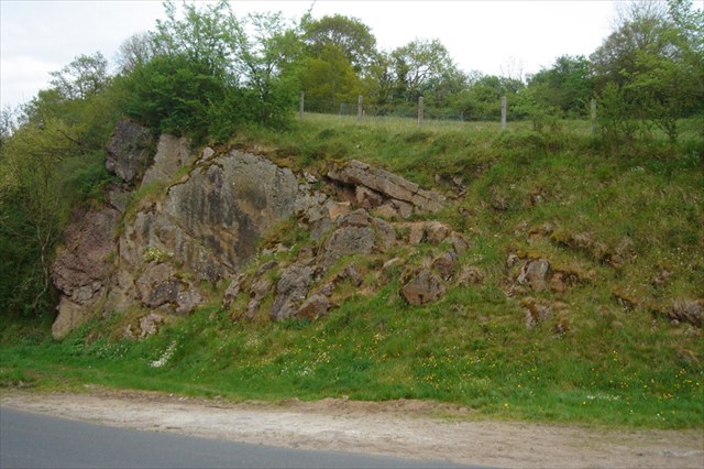
L’escarpement rocheux montre des conglomérats pourpres en bancs épais surmontés par des arkoses en bancs plus minces.
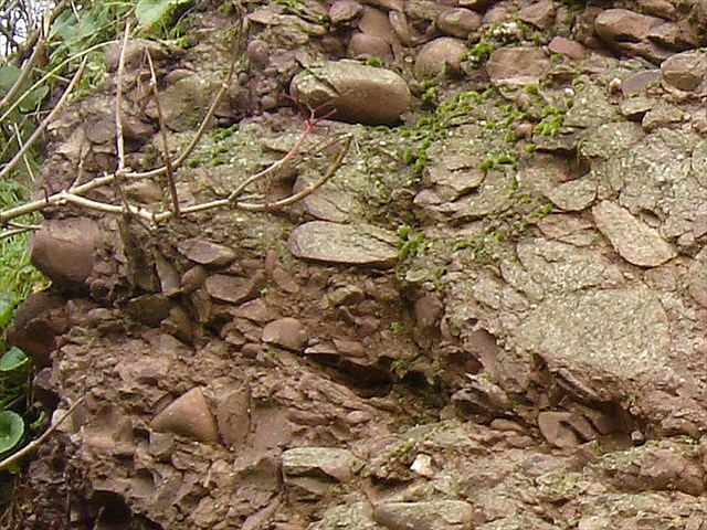
Il contient des galets de taille différentes composés de roches arrachées au flysch briovérien lors de l'érosion de la chaine cadomienne. Le fort degré d'usure et la grande taille de certains galets indiquent un transport par un courant de forte énergie et un dépôt proche des reliefs érodés.Les galets, presque jointifs, sont enrobés dans une matrice gréseuse pourprée. La couleur rouge, est due à la présence d’oxydes de fer, certains galets sont recouverts d’une mince couche de fer. Ces conglomérats sont désignés sous le nom de «Poudingue de base».
Calcaire du cambrien:
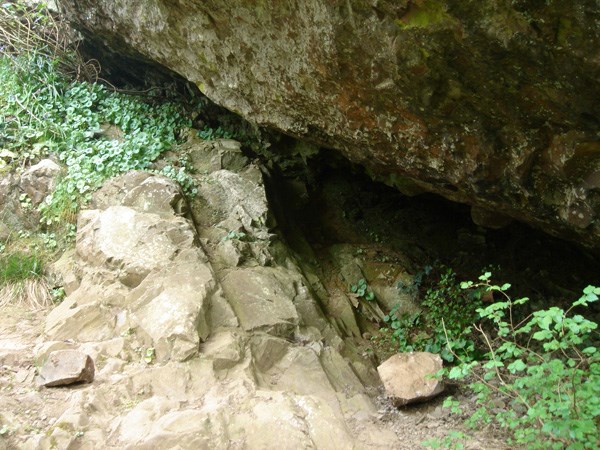
Les calcaires de laize sont des calcaires magnésiens bien empilés. Ils ont été plissés: ici les bancs pendent vers le sud. Ces calcaires appartiennent au flanc nord du synclinal d'urville formé lors de l'orogénése varisque.
Les Calcaires de Laize sont gris beige à rose quand ils sont pigmentés d’oxyde de fer. De multiples cristallisations de calcite appelées «bird-eyes» leur donne un aspect marbré. Ces calcaires sont aussi connus sous le nom de marbre de Vieux, localité où ils ont été exploités par les Romains.

La discordance cadomienne
Elle tire son nom de Caen (cadomus en latin). La discordance cadomienne matérialise une des grandes coupures du calendrier géologique, entre le précambrien et le paléozoïque.
Des questions simples dont les réponses sont soit dans le descriptif, soit dans le panneau d'informations.
1- Quel est approximativment la hauteur de l'escarpement ?
2- Que pouvez vous voir dans le poudingue de base ?
3- Quel type de roche se trouve au dessus de la surface d'érosion post-cadomienne ?
4- Quel type de roche se trouve en dessous de la surface d'érosion post-cadomienne ?
5- Quel est l'autre nom des calcaires de la Laize ?
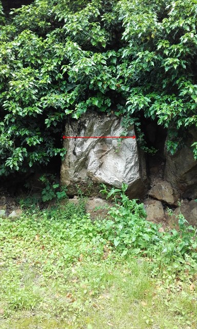
6- Quel est approximativement la largeur du bloc de calcaire ? (photo N°4)
7- Donnez moi le nombre inscrit derrière le panneau «STOP»
Enfin, mais optionnel, vous pouvez joindre une photo de vous devant l'escarpement.
Loguez cette cache "Found it" et envoyez-moi vos propositions de réponses soit via mon profil, soit via la messagerie geocaching.com (Message Center), et je vous contacterai en cas de problème.
The hamlet of Jacob- mesnil located in the town of Bretteville-sur-Laize presents many outcrops, but is also the type locality where the unconformity Cadomian was defined by L. Bertrand in 1921 .
Basic Poudingue Cambrian :
The rocky escarpment show a thick benches of purple conglomerates overcome by thinner benches of arkose.
It contains different sized pebbles consisting of rock torn from the flysch Brioverian during erosion of Cadomian chain. The high degree of wear and the large size of some pebbles indicate a transport by a high energy current and deposition near of eroded landforms. The pebbles, almost adjoining, are coated in a matrix of puprple sandstone. The red color is due to the presence of iron oxides, some pebbles are coated with a thin layer iron. These conglomerates are referred to as "basic Poudingue".
Limestone of the Cambrian
The limestone from Laize are magnesian limestone well stratified. They were folded : here the benches hang south. These limestone apparteinnent north flank of the syncline urville formed during the Variscan orogeny.
The limestones are gray beige to pink when they are pigmented with iron oxide. Multiple calcite crystallization called "birdseye" gives them a mottled appearance. These limestones are also known under the name of marble from Vieux locality where they were exploited by the Romans.
The unconformity Cadomian
It takes its name from Caen ( cadomus in Latin) .The Cadomian unconformity materializes a major cuts in geological calendar, between Precambrian and Paleozoic .
Simple questions whose answers are either in the descriptive or in the info panel.
1- What is the maximum height of the cliff?
2- What can you see in the basic pudding stone ?
3- What type of rock is located above the post-Cadomian erosion surface?
4- What type of rock is below the post-Cadomian erosion surface?
5- What is another name for the limestone from the Laize?
6- What is (approximately) the width of the limestone block? (photo N°4)
7- Give me the number written behind the steering panel "STOP"
Last but optional, you can attach a picture of you in front of the escarpment.
You can log this earthcache " Found it " and send me your proposals of answers either via my profile, or via the geocaching.com messaging (Center message), and I shall contact you in case of problem.