Ah ... le petit Mont-Blanc. EarthCache
Ah ... le petit Mont-Blanc.
-
Difficulty:
-

-
Terrain:
-

Size:  (other)
Please note Use of geocaching.com services is subject to the terms and conditions
in our disclaimer.
La montagne de sel...
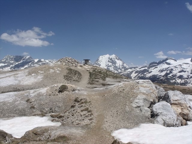 Le Petit Mont blanc se situe sur la commune de Pralognan la Vanoise et culmine à 2677 mètres d'altitude. Paysage lunaire et belvédère grandiose sur le "vrai" Mont-Blanc et la Grande Casse.
L’intérêt géologique :
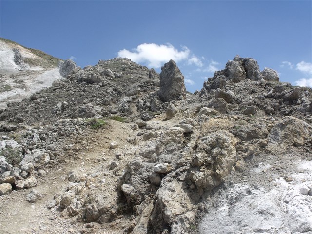
Près du sommet, le sentier de montée serpente entre des cônes de dissolution et des pics de cargneule aux formes étranges. Le sommet est tout blanc, le gypse a parfois l’aspect de gros sel car c’est une roche tendre.
Du col du Mône (avant l'ascension finale) se situe une ligne de faille qui sépare deux formations géologiques différentes :
Le roc du Mône, formation de calcaires et dolomies du Jurassique dont la série stratigraphique est inversée, et le Petit Mont-Blanc, formé de gypse, une roche très blanche qui présente quant à lui un paysage lunaire avec ses roches blanches et globulaires.
Le Petit mont Blanc ou « Montagne de sel » comme disaient les anciens, est en réalité du gypse exploité pour la fabrication du plâtre et utilisé pour étanchéifier les murs en pierres sèches. C'est aussi un sommet remarquable par sa forme très arrondie et par le relief de détail très particulier que ces roches déterminent, sculpté de ravines profondes et escarpées sur le versant oriental et criblé de dépressions qui lui donnent cet aspect "lunaire" aux abords du sommet.
Le Petit Mont-Blanc est un belvédère très fréquenté, car d'accès assez facile, qui se détache sur la crête de rive gauche du cours inférieur du Doron de Chavière entre le Rocher de Plassa et le Roc de la Pêche.
La montagne doit évidemment son nom à la couleur blanche des roches qui la constituent sur la majeure partie de sa hauteur et qui sont essentiellement des gypses d'âge triasique. Ces gypses représentent une dilatation locale de la bande de matériel sédimentaire qui est pincée le long de la cicatrice de Chavière et qui s'étrangle vers le sud (col de Chavière) comme vers le nord. Ce matériel s'intercale entre les unités de couverture "carbonatée" (Trias moyen à Éocène) de Chanrossa (Roc de la Pêche) et du Rocher de Plassa, d'une part, et les terrains siliceux permo-triasiques des basses pentes du versant, d'autre part.
 Les gypses triasiques y affleurent sur une dénivellation de plusieurs centaines de mètres ; cette masse anormalement épaisse a été accumulée là par le jeu de la tectonique : en effet on trouve, emballées au sein de ces gypses, des panneaux rocheux de plusieurs centaines de mètres de côté, qui sont formés de roches diverses et disposées de façon incohérente.
D'autre part les gypses reposent, en général par l'intermédiaire d'une semelle de cargneules sur des terrains très divers, en recoupant les strates selon une surface de forme capricieuse et sans rapport avec la disposition de ces dernières. Lorsqu'elle est dénudée par l'érosion cette surface se révèle lissée comme un poli glaciaire, ce qui confère à son substrat l'aspect de roches moutonnées.
RAPPEL: PAS DE BOITE A TROUVER SUR PLACE...
POUR VALIDER LE FOUND-IT: REPONDEZ AUX QUESTIONS SUIVANTES:
1) De quand datent les gypses triasiques (en MA) ?
2) Définition sommaire du gypse ?
3) Définition d'un cargneule ?
4) Au WP1: Prenez du gypse entre vos doigts et sentez le: quelle odeur dégage -t-il ?
5) Au WP2: Mesurez la hauteur de la colonne de cargneule comme sur la photo (à + ou - 20 cm) ?
6) T° de transformation du gypse en plâtre ?
7) Photo optionnelle au sommet...
Loguez cette cache "Found it" et envoyez-moi vos propositions de réponses soit via mon profil, soit via la messagerie geocaching.com (Message Center), et je vous contacterai en cas de problème.
AVEC CETTE EARTHCACHE, VOUS ALLEZ SUR LA "LUNE" .
Compter environ 3h de marche et 900 mètres de dénivelé pour atteindre le sommet.Partir du parking du Pont de la Peche (1764m)
BONNE RANDONNEE ET PRUDENCE AVEC LES ENFANTS.
 The Salt Mountain ...
 Le Petit Mont Blanc is located in the town of Pralognan Vanoise and culminates at 2677 meters altitude. moonscape and grand gazebo on the "real" Mont Blanc and the Grande Casse.
Near the top of the ascent path winds between dissolution cones and spikes cargneule with strange shapes. The top is white, gypsum sometimes has the appearance of coarse salt as it is a soft rock.
Le Petit Mont Blanc is located in the town of Pralognan Vanoise and culminates at 2677 meters altitude. moonscape and grand gazebo on the "real" Mont Blanc and the Grande Casse.
Near the top of the ascent path winds between dissolution cones and spikes cargneule with strange shapes. The top is white, gypsum sometimes has the appearance of coarse salt as it is a soft rock.
From cervical Mone (prior to ascension final) is a fault line between two different geological formations:the rock of Mone, limestone formation and dolomites of Jurassic whose stratigraphic series is reversed, and the Petit Mont Blanc, consisting of gypsum, a very white rock which for its part has a lunar landscape with white rocks and globular.
Le Petit Mont Blanc, or "Mountain of salt" as the ancients said, is actually the gypsum used to manufacture plaster and used to seal the stone walls. It is also a remarkable summit by its very rounded shape and by the very specific detail relief determine that these rocks, carved deep and steep gullies on the eastern slope and riddled with depressions that give this aspect "lunar" near the Mountain peak.
Le Petit Mont Blanc is a popular lookout because quite easy, which stands on the crest of the left bank lower Doron Chavière between the Rock of the Rock Plassa and Fisheries.
The mountain is obviously named after the white color of the rocks that constitute the bulk of its height and which are mainly gypsum of Triassic age. These gypsum represent a local expansion of the sedimentary material strip which is pinched along the scar Chavière and chokes south (Chavière neck) as north. This material is inserted between the coverage units "carbonated" (Middle Triassic to Eocene) of Chanrossa (Roc Fisheries) and the Rock of Plassa the one hand, and the Permo-Triassic siliceous low slopes of the catchment on the other hand.
 The Triassic gypsum outcrops are on a drop of several hundred meters; This abnormally thick mass was accumulated here by the play of tectonics: indeed there is, packed within these gypsum, rock panels of several hundred meters wide, which are formed of various rocks and arranged inconsistently.
On the other hand gypsum based, usually via a cargneules sole on a variety of grounds, in overlapping strata as a capricious form surface and unrelated to the provision of the latter. When exposed by erosion reveals that surface is smooth as a polished ice, giving her the appearance of substrate moutonnées rocks.
1) How old is the Triassic gypsum (in MA)?
2) Brief Definition gypsum?
3) Setting a cargneule
4) in WP1: Take gypsum between your fingers and the feel: what t smell it gives off
5) in WP2: Measure the height of the column of cargneule as the picture (at + or - 20 cm)
6) T ° for manufacturing gypsum plaster
7) optional photo at the top ...?
phones Sign the cache "Found it" and send me your answers proposals either via my profile or via email geocaching.com ( Message Center), and I will contact you in case of problems.
Earthcache WITH THIS, YOU GO ON "MOON".
Allow about 3 hours walk and 900 vertical meters to reach the sommet.Partir the parking of the Fishing Bridge (1764m)
GOOD CAUTION AND HIKING WITH CHILDREN.
POUR LA MESURE C'EST ICI/MEASUREMENT IS HERE 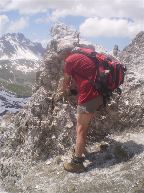 PENSEZ AU METRE A RUBAN ? /THINK METER BAND?
ET SURTOUT NE RATEZ PAS LA BELLE TRADI TOUTE PROCHE DE "ΠRO&LN"
PENSEZ AU METRE A RUBAN ? /THINK METER BAND?
ET SURTOUT NE RATEZ PAS LA BELLE TRADI TOUTE PROCHE DE "ΠRO&LN"
(Le petit Mont-Blanc: https://coord.info/GC5CJKB
******************************
AND ESPECIALLY DO NOT MISS THE ALL NEAR BELLE TRADI "ΠRO & LN"
(The small Mont Blanc: https://coord.info/GC5CJKB
BELLE BALADE JE VOUS ATTENDS/BEAUTIFUL WALKING YOU WAIT 
Additional Hints
(Decrypt)
Zntavsvdhr oryiéqèer nirp gnoyr q'bevragngvba.
*******************
Ornhgvshy tnmrob jvgu ivrjcbvag.