Le cap a été ravagé par le feu entre le 24 et le 25 juillet 2017
Merci d'avoir le coeur de prendre des photos pour témoigner du sinistre et de la reprise de la végétation
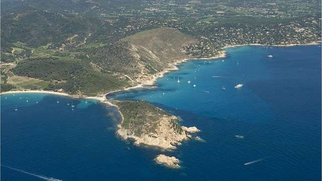
Un tombolo est un cordon littoral de sédiments reliant deux étendues terrestres. C'est un terme géomorphologique concernant un ccordon littoral entre une île ou un îlot et la côte (continent ou une autre île). Le dépôt sédimentaire (sableux ou graveleux) est généralement mis en place par la refraction du train de vagues due à l'île : celle-ci protège la zone située entre elle et l'autre étendue terrestre, provoquant le dépôt des sédiments où les vagues se rencontrent.
Durant des siècles, les éléments océaniques ont déposé au fil des marées et des tempêtes, du sable, des galets et des alluvions dans l’espace qui séparait l’îlot du continent.
Une flèche de sable, appelée tombolo, s’est ainsi façonnée.
Vous pouvez vous rendre de différentes façons au cap Taillat mais la plus courte est de vous garer à l'Escalet (payant jusqu'à 18h) et de prendre le chemin du littoral (1/2h de marche pas trop difficile)
Pour ceux qui veulent en savoir plus
sur le film le gendarme en ballade on apercoit le site, les voitures pouvaient y accéder !
Le tournage du gendarme
POUR VALIDER CETTE CACHE, REPONDEZ AUX QUESTIONS SUIVANTES:
1°) Pouvez vous expliquer la formation du tombolo du cap Taillat ?
2°) De qu'elle couleur sont les roches au WP3 ?
3°) Vous pouvez prendre une photo elle est facultative
Loguez cette cache "Found it" et envoyez-moi vos propositions de réponses soit via mon profil, soit via la messagerie geocaching.com (Message Center), et je vous contacterai en cas de problème.
BONNE BALADE ET BON BOL D'AIR...
Félicitation à Verturin pour son FTF

(web traduction)
The cap was ravaged by the fire between 24 and 25th on July 2017 Thank you for having the heart to take photos to testify of the disaster and the resumption of the vegetation
A tombolo is an offshore bar of sediments connecting two ground areasIt is is a géomorphologique term concerning a littoral ccordon between an island or an island and the coast (continent or another island). The sedimentary deposit sand or rocks is generally set up by the refraction of the train of waves due to the island: this one protects the zone situated between her and the other ground area, causing the deposit of sediments where waves meet.
For centuries, the oceanic elements deposited in the course of tides and storms, of sand, pebbles and alluviums in the space which separated the island of the continent.
An arrow of sand, called tombolo, so shaped.
You can go in various way on the cap Taillat but the shortest is to park you in Escalet (paying till 18h) and to take the way of the coast path(1 / 2h of not too difficult walking)
TO VALIDATE THIS HIDING PLACE, ANSWER the FOLLOWING QUESTIONS:
1 °)Give some explanation the formation of the tombolo of the capTaillat.
2 °) What is the color of the rocks in the WP3?
3 °) You can take a photo it is optional
Log it " Found it " and send me your proposals of answers either via my profile, or via the geocaching.com messaging (Center message), and I shall contact you in case of problem.
GOOD STROLL AND GOOD BREATH OF FRESH AIR...